
ファイル:Earth dry elevation.stl
この STL ファイルのこの PNG プレビューのサイズ: 800 × 600 ピクセル. その他の解像度: 320 × 240 ピクセル | 640 × 480 ピクセル | 1,024 × 768 ピクセル | 1,280 × 960 ピクセル | 2,560 × 1,920 ピクセル | 5,120 × 3,840 ピクセル。
元のファイル (5,120 × 2,880 ピクセル、ファイルサイズ: 27.66メガバイト、MIME タイプ: application/sla)
ウィキメディア・コモンズのファイルページにある説明を、以下に表示します。
|
View Earth dry elevation.stl on viewstl.com
概要
| 解説 |
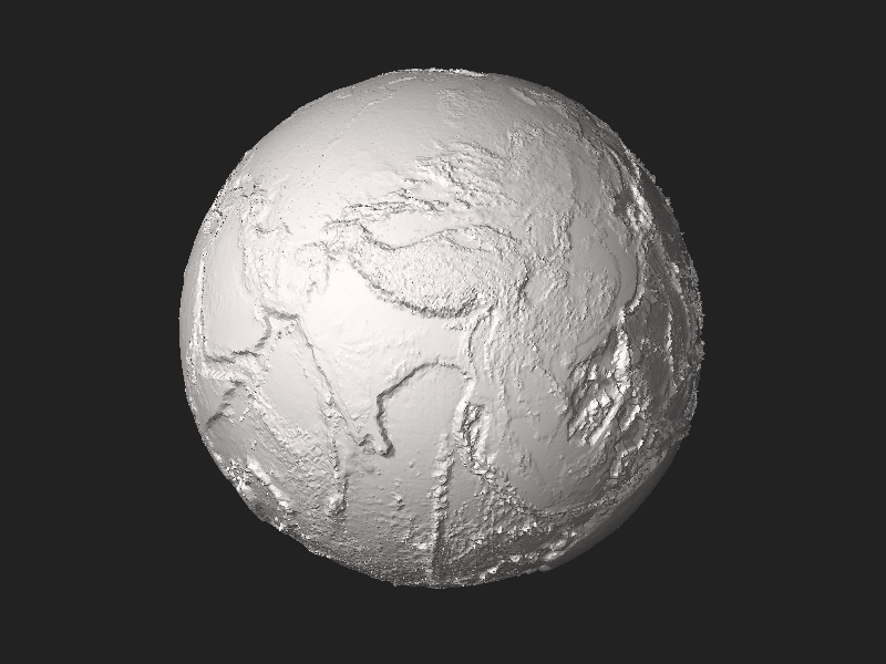
English: Earth without liquid water greatly exaggerated elevation model by CMG Lee using depthmap File:Earth_dry_elevation.png generated from NASA Visible Earth topography and bathymetry data. |
|||
| 日付 | ||||
| 原典 | 投稿者自身による著作物 | |||
| 作者 | Cmglee | |||
| その他のバージョン |
|


Python source
#!/usr/bin/env python

exaggeration   = 10
header         = ('Dry Earth %s-times-exaggerated elevation model by CMG Lee using NASA data.'
                  % (exaggeration))
path_png_alt   = 'earth_dry_elevation.png' ## 1-channel equirectangular PNG
luma_datum     = 141                       ## image intensity level (of 0-255) of datum
radius_datum   = 6378.137                  ## mean radius of zero level in km
f_wgs84        = 1 / 298.257223563         ## WGS84 flattening factor
km_per_luma    = (10.994 + 8.848) / 255 * exaggeration ## min and max elevations in km
scale          = 1e-2                      ## overall scale of model in km^-1
lat_offset     = 5.0 / 8                   ## rotation around planet axis in revolutions
n_division     = 200                       ## each cubic face divided into n_division^2 squares

class Png:
 def __init__(self, path):
  (self.width, self.height, self.pixels, self.metadatas) = png.Reader(path).read_flat()
 def __str__(self): return str((self.width, self.height, len(self.pixels), self.metadatas))

import time, re, math, struct, png
time.start = time.time()
def log(string): print('%6.3fs\t%s' % (time.time() - time.start, string))
def fmt(string): ## string.format(**vars()) using tags {expression!format} by CMG Lee
 def f(tag): i_sep = tag.rfind('!'); return (re.sub('\.0+$', '', str(eval(tag[1:-1])))
  if (i_sep < 0) else ('{:%s}' % tag[i_sep + 1:-1]).format(eval(tag[1:i_sep])))
 return (re.sub(r'(?<!{){[^{}]+}', lambda m:f(m.group()), string)
         .replace('{{', '{').replace('}}', '}'))
def append(obj, string): return obj.append(fmt(string))
def tabbify(cellss, separator='|'):
 cellpadss = [list(rows) + [''] * (len(max(cellss, key=len)) - len(rows)) for rows in cellss]
 fmts = ['%%%ds' % (max([len(str(cell)) for cell in cols])) for cols in zip(*cellpadss)]
 return '\n'.join([separator.join(fmts) % tuple(rows) for rows in cellpadss])
def hex_rgb(colour): ## convert [#]RGB to #RRGGBB and [#]RRGGBB to #RRGGBB
 return '#%s' % (colour if len(colour) > 4 else ''.join([c * 2 for c in colour])).lstrip('#')
def viscam_colour(colour):
 colour_hex      = hex_rgb(colour)
 colour_top5bits = [int(colour_hex[i:i+2], 16) >> 3 for i in range(1,7,2)]
 return (1 << 15) + (colour_top5bits[0] << 10) + (colour_top5bits[1] << 5) + colour_top5bits[2]
def roundm(x, multiple=1):
 if   (isinstance(x, tuple)): return tuple(roundm(list(x), multiple))
 elif (isinstance(x, list )): return [roundm(x_i, multiple) for x_i in x]
 else: return int(math.floor(float(x) / multiple + 0.5)) * multiple
def average(xs): return None if (len(xs) == 0) else float(sum(xs)) / len(xs)
def flatten(lss): return [l for ls in lss for l in ls]
def rotate(facetss, degs): ## around x then y then z axes
 (deg_x,deg_y,deg_z) = degs
 (sin_x,cos_x) = (math.sin(math.radians(deg_x)), math.cos(math.radians(deg_x)))
 (sin_y,cos_y) = (math.sin(math.radians(deg_y)), math.cos(math.radians(deg_y)))
 (sin_z,cos_z) = (math.sin(math.radians(deg_z)), math.cos(math.radians(deg_z)))
 facet_rotatess = []
 for facets in facetss:
  facet_rotates = []
  for i_point in range(4):
   (x,y,z) = [facets[3 * i_point + i_xyz] for i_xyz in range(3)]
   if (x is None or y is None or z is None): facet_rotates += [x,y,z]

   else:
    (y,z) = (y * cos_x - z * sin_x, y * sin_x + z * cos_x) ## rotate about x
    (x,z) = (x * cos_y + z * sin_y,-x * sin_y + z * cos_y) ## rotate about y
    (x,y) = (x * cos_z - y * sin_z, x * sin_z + y * cos_z) ## rotate about z
    facet_rotates += [round(value, 9) for value in [x,y,z]]
  facet_rotatess.append(facet_rotates)
 return facet_rotatess
def translate(facetss, ds): ## ds = (dx,dy,dz)
 return [facets[:3] + [facets[3 * i_point + i_xyz] + ds[i_xyz]
                       for i_point in range(1,4) for i_xyz in range(3)]  for facets in facetss]
def flip(facetss): return [facets[:3]+facets[6:9]+facets[3:6]+facets[9:] for facets in facetss]

def cube_xyz_to_sphere_xyz(cube_xyzs):
 (x,y,z)                         = [float(xyz) for xyz in cube_xyzs]
 (x_squared,y_squared,z_squared) = (x * x,y * y,z * z)
 return (x * (1 - (y_squared + z_squared) / 2 + y_squared * z_squared / 3) ** 0.5,
         y * (1 - (x_squared + z_squared) / 2 + x_squared * z_squared / 3) ** 0.5,
         z * (1 - (y_squared + x_squared) / 2 + y_squared * x_squared / 3) ** 0.5)
def xyz_to_lla(xyzs):
 (x,y,z) = xyzs
 alt     = (x * x + y * y + z * z) ** 0.5
 lon     = math.atan2(y, x)
 lat     = math.asin(z / alt)
 return (lat,lon,alt)
deg_90 = math.pi / 2
def find_alt(lat_lons, altss):
  (lat,lon) = lat_lons
  if   (lat ==  deg_90): alt = average(altss[ 0])
  elif (lat == -deg_90): alt = average(altss[-1])
  else:
   (width,height) = (len(altss[0]),len(altss))
   x              = (0.5 + lon / (deg_90 * 4) + lat_offset) * width
   y              = (0.5 - lat / (deg_90 * 2)             ) * height
   (x_int,y_int)  = (int(x)   , int(y)   )
   (x_dec,y_dec)  = (x - x_int, y - y_int)
   (x0,x1)        = (x_int % width , (x_int + 1) % width )
   (y0,y1)        = (y_int % height, (y_int + 1) % height)
   alt            = ((altss[y0][x0] * (1 - x_dec) + altss[y1][x0] * x_dec) * (1 - y_dec) +
                     (altss[y0][x1] * (1 - x_dec) + altss[y1][x1] * x_dec) *      y_dec)
  # print(map(math.degrees, lat_lons), y,x, alt)
  return alt
def radius_wgs84(lat):
 if (lat in radius_wgs84.cachess): return radius_wgs84.cachess[lat]
 (sin_lat, cos_lat)        = (math.sin(lat), math.cos(lat))
 ff                        = (1 - f_wgs84) ** 2
 c                         = 1 / (cos_lat ** 2 + ff * sin_lat ** 2) ** 0.5
 s                         = c * ff
 radius_c_s_s              = (radius_datum * c, radius_datum * s)
 radius_wgs84.cachess[lat] = radius_c_s_s
 return radius_c_s_s
radius_wgs84.cachess = {}
def lla_to_sphere_xyz(llas):
 (lat,lon,alt)        = llas
 (sin_lat,sin_lon)    = (math.sin(lat),math.sin(lon))
 (cos_lat,cos_lon)    = (math.cos(lat),math.cos(lon))
 (radius_c, radius_s) = [(c_s_radius + alt * km_per_luma) * scale
                         for c_s_radius in radius_wgs84(lat)]
 return (radius_c * cos_lat * cos_lon,radius_c * cos_lat * sin_lon,radius_s * sin_lat)
def xyz_alt_to_xyza(xyzs, altss):
 (lat,lon,alt) = xyz_to_lla(xyzs)
 alt           = find_alt((lat,lon), altss)
 lla_alts      = [list(lla_to_sphere_xyz((lat,lon,alt))), alt]
 return lla_alts

log("Read elevation data")
png_alt = Png(path_png_alt)
if (png_alt.metadatas['planes'] != 1): print("%s not 1-channel PNG" % (path_png_alt)); sys.exit(1)
log(png_alt)
altss = [[png_alt.pixels[png_alt.width * y + x] - luma_datum
          for x in range(png_alt.width)] for y in range(png_alt.height)] ## altss[y][x]

log("Find vertices")
k       = 2.0 / n_division
range_k = range(n_division + 1)
face_vertex_llassss = [ ## [0=top][i_y][i_x][xyz,alt]
 [[xyz_alt_to_xyza((x*k-1,y*k-1,    1), altss) for y in range_k] for x in range_k],
 [[xyz_alt_to_xyza((x*k-1,   -1,y*k-1), altss) for y in range_k] for x in range_k],
 [[xyz_alt_to_xyza((    1,x*k-1,y*k-1), altss) for y in range_k] for x in range_k],
 [[xyz_alt_to_xyza((y*k-1,x*k-1,   -1), altss) for y in range_k] for x in range_k],
 [[xyz_alt_to_xyza((y*k-1,    1,x*k-1), altss) for y in range_k] for x in range_k],
 [[xyz_alt_to_xyza((   -1,y*k-1,x*k-1), altss) for y in range_k] for x in range_k],
]

log("Add facets") ## cube xyz -> ll(a) -> image xy -> a -> sphere xyz
facetss = []
for (i_face,face_vertex_llasss) in enumerate(face_vertex_llassss):
 for  v in range(n_division):
  for u in range(n_division):
   (xyz00, alt00) = face_vertex_llasss[v    ][u    ]
   (xyz01, alt01) = face_vertex_llasss[v    ][u + 1]
   (xyz10, alt10) = face_vertex_llasss[v + 1][u    ]
   (xyz11, alt11) = face_vertex_llasss[v + 1][u + 1]
   (xyz_m, alt_m) = xyz_alt_to_xyza([average(xyzs) for xyzs in zip(*(xyz00,xyz01,xyz10,xyz11))],
                                    altss)
   if (alt_m > max(alt00,alt01,alt10,alt11) or alt_m < min(alt00,alt01,alt10,alt11)):
    facetss.append([None,0,0] + xyz_m + xyz00 + xyz10)
    facetss.append([None,0,0] + xyz_m + xyz10 + xyz11)
    facetss.append([None,0,0] + xyz_m + xyz11 + xyz01)
    facetss.append([None,0,0] + xyz_m + xyz01 + xyz00)
   else:
    if (abs(alt00 - alt11) < abs(alt01 - alt10)):
     facetss.append([None,0,0] + xyz00 + xyz10 + xyz11)
     facetss.append([None,0,0] + xyz11 + xyz01 + xyz00)
    else:
     facetss.append([None,0,0] + xyz10 + xyz11 + xyz01)
     facetss.append([None,0,0] + xyz01 + xyz00 + xyz10)

log("Calculate normals")
for facets in facetss:
 if (facets[0] is None or facets[1] is None or facets[2] is None):
  us      = [facets[i_xyz + 9] - facets[i_xyz + 6] for i_xyz in range(3)]
  vs      = [facets[i_xyz + 6] - facets[i_xyz + 3] for i_xyz in range(3)]
  normals = [us[1]*vs[2] - us[2]*vs[1], us[2]*vs[0] - us[0]*vs[2], us[0]*vs[1] - us[1]*vs[0]]
  normal_length = sum([component * component for component in normals]) ** 0.5
  facets[:3] = [-round(component / normal_length, 10) for component in normals]

# log(tabbify([['N%s'  % (xyz   )                   for xyz in list('xyz')] +
#              ['%s%d' % (xyz, n) for n in range(3) for xyz in list('XYZ')] + ['RGB']] + facetss))

log("Compile STL")
outss = ([[('STL\n\n%-73s\n\n' % (header[:73])).encode('utf-8'), struct.pack('<L',len(facetss))]] +
         [[struct.pack('<f',float(value)) for value in facets[:12]] +
          [struct.pack('<H',0 if (len(facets) <= 12) else
                            viscam_colour(facets[12]))] for facets in facetss])
out   = b''.join([bytes(out) for outs in outss for out in outs])
# out += ('\n\n## Python script to generate STL\n\n%s\n' % (open(__file__).read())).encode('utf-8')
log("Write STL")
with open(__file__[:__file__.rfind('.')] + '.stl', 'wb') as f_out: f_out.write(out)
log("#bytes:%d\t#facets:%d\ttitle:\"%-73s\"" % (len(out), len(facetss), header[:73]))
ライセンス
この作品の著作権者である私は、この作品を以下のライセンスで提供します。
このファイルはクリエイティブ・コモンズ 表示-継承 4.0 国際ライセンスのもとに利用を許諾されています。
- あなたは以下の条件に従う場合に限り、自由に
- 共有 – 本作品を複製、頒布、展示、実演できます。
- 再構成 – 二次的著作物を作成できます。
- あなたの従うべき条件は以下の通りです。
- 表示 – あなたは適切なクレジットを表示し、ライセンスへのリンクを提供し、変更があったらその旨を示さなければなりません。これらは合理的であればどのような方法で行っても構いませんが、許諾者があなたやあなたの利用行為を支持していると示唆するような方法は除きます。
- 継承 – もしあなたがこの作品をリミックスしたり、改変したり、加工した場合には、あなたはあなたの貢献部分を元の作品とこれと同一または互換性があるライセンスの下に頒布しなければなりません。
| このファイルをアップロードした人はウィキメディア財団 3D 特許権条項を承諾しています。 このファイルならびにファイル中に描写した対象物はいずれも私の作品です。 ファイル中に描写した対象物の使用者、製造者、配布者に対し、このファイルならびにファイル中に描写した対象物の製造、製造委託、使用、販売受託、販売、輸入ならびに配布に関して私はここに全世界で著作権料無料の後払いのない非独占で不変の永続するライセンスを、私が現在所有する特許もしくは今後の特許申請による一切の追加料金を請求することなく付与するものとし、それにより私が現在所有するもしくは今後の申請による特許権のいかなる主張に反することはありません。 万一このライセンスの英語版原文と翻訳の間で意味や解釈に相違がある場合、英語原文を優先するものとします。 |
ファイルの履歴
過去の版のファイルを表示するには、その版の日時をクリックしてください。
| 日付と時刻 | サムネイル | 寸法 | 利用者 | コメント | |
|---|---|---|---|---|---|
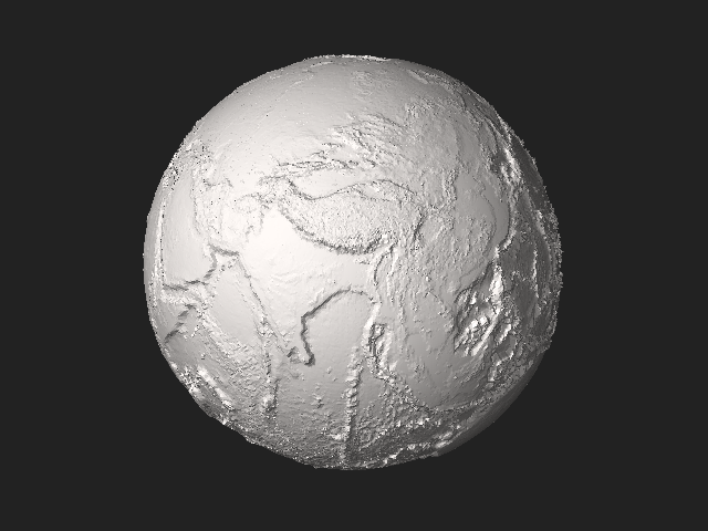
| 現在の版 | 2018年4月15日 (日) 13:21 | 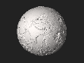 | 5,120 × 2,880 (27.66メガバイト) | Cmglee | Rotate to show the Himalayas and Mariana Trench in the thumbnail. |
| 2018年4月15日 (日) 12:43 |  | 5,120 × 2,880 (27.63メガバイト) | Cmglee | User created page with UploadWizard |
ファイルの使用状況
以下のページがこのファイルを使用しています:
グローバルなファイル使用状況
以下に挙げる他のウィキがこの画像を使っています:
- bn.wikipedia.org での使用状況
- crh.wikipedia.org での使用状況
- en.wikipedia.org での使用状況
- en.wikiversity.org での使用状況
- eu.wikipedia.org での使用状況
- gl.wikipedia.org での使用状況
- hy.wikipedia.org での使用状況
- kk.wikipedia.org での使用状況
- lbe.wikipedia.org での使用状況
- myv.wikipedia.org での使用状況
- my.wikipedia.org での使用状況
- ro.wikipedia.org での使用状況
- tk.wikipedia.org での使用状況
- tt.wikipedia.org での使用状況
- www.wikidata.org での使用状況
- zh.wikipedia.org での使用状況