
ファイル:Decision Support System for John Day Reservoir.jpg
高解像度版はありません。
Decision_Support_System_for_John_Day_Reservoir.jpg (477 × 364 ピクセル、ファイルサイズ: 178キロバイト、MIME タイプ: image/jpeg)
ウィキメディア・コモンズのファイルページにある説明を、以下に表示します。
|
概要
| 解説 |
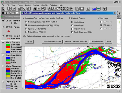
English: This set of tools, in conjunction with 2-dimensional hydraulic modeling, is being used to estimate the effects of reservoir level and water discharge fluctuations on aquatic and terrestrial habitats in John Day Reservoir. Different scenarios being studied now range from typical reservoir levels at high and low discharges to a simulation of what things might be like if the river were to return to natural conditions |
| 日付 | Retrieved June 17 2009. |
| 原典 | http://wfrc.usgs.gov/research/geospatial%20studies/STGeospat4.htm ...returns HTTP status 404. The most recent non-404 snapshot of this page from archive.org is: https://web.archive.org/web/20100527105316/http://wfrc.usgs.gov/research/geospatial%20studies/STGeospat4.htm |
| 作者 | USGS: Project contact Michael J. Parsley, U.S. Geological Survey |
ライセンス
この画像およびメディアは、アメリカ合衆国内務省の実務機関であるアメリカ地質調査所に属する者が職務上作成した著作物のみで構成されているため、アメリカ合衆国国内でパブリックドメインの状態にあります。詳細についてはUSGSの著作物に関する取扱い(英語)をご覧ください。
|
ファイルの履歴
過去の版のファイルを表示するには、その版の日時をクリックしてください。
| 日付と時刻 | サムネイル | 寸法 | 利用者 | コメント | |
|---|---|---|---|---|---|
| 現在の版 | 2009年6月17日 (水) 11:40 | | 477 × 364 (178キロバイト) | Mdd | {{Information |Description={{en|1=This set of tools, in conjunction with 2-dimensional hydraulic modeling, is being used to estimate the effects of reservoir level and water discharge fluctuations on aquatic and terrestrial habitats in John Day Reservoir. |
ファイルの使用状況
以下のページがこのファイルを使用しています:
グローバルなファイル使用状況
以下に挙げる他のウィキがこの画像を使っています:
- ar.wikipedia.org での使用状況
- el.wikipedia.org での使用状況
- en.wikipedia.org での使用状況
- es.wikipedia.org での使用状況
- fa.wikipedia.org での使用状況
- fr.wikipedia.org での使用状況
- ko.wikipedia.org での使用状況
- sr.wikipedia.org での使用状況
- tr.wikipedia.org での使用状況
- uk.wikipedia.org での使用状況
- www.wikidata.org での使用状況