
ファイル:Cold War border changes.png
高解像度版はありません。
Cold_War_border_changes.png (599 × 436 ピクセル、ファイルサイズ: 25キロバイト、MIME タイプ: image/png)
ウィキメディア・コモンズのファイルページにある説明を、以下に表示します。
|
概要
| 解説 |
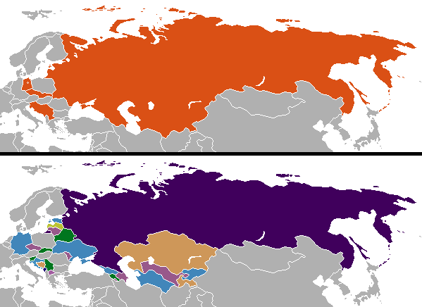
English: Changes in internationally recognized boundaries of countries after the end of the Cold War. Orange in the "before" map represents the territories as of 1991 which were affected. |
| 日付 | |
| 原典 | 投稿者自身による著作物 |
| 作者 | Aivazovsky (talk) (Uploads) |
ライセンス
| この著作物は、著作者である英語版ウィキペディアのAivazovskyさんによって権利が放棄され、パブリックドメインとされました。これは全世界で適用されます。 一部の国では、これが法的に可能ではない場合があります。その場合は、次のように宣言します。 Aivazovskyは、あらゆる人に対して、法により必要とされている条件を除き、如何なる条件も課すことなく、あらゆる目的のためにこの著作物を使用する権利を与えます。 |
Colored by User:Aivazovsky from public domain Wikimedia Commons source.
元のアップロードログ
元のファイルページはこちら。以下の利用者は全てen.wikipediaに属します。
| 日付と時刻 | 寸法 | 利用者 | コメント |
|---|---|---|---|
| 2009-12-11 10:57 | 599×436× (15723 bytes) | Ithanyx | Switched to most up-to-date template version. |
| 2008-07-19 07:01 | 599×436× (15610 bytes) | Hoshie | added the last change of the cold war: Kosovo |
| 2007-09-24 04:24 | 599×436× (20607 bytes) | Hoshie | fixed shading on two islands west of the Estonian SSR |
| 2007-02-27 02:21 | 599×436× (15749 bytes) | Aivazovsky | |
| 2006-10-10 06:35 | 599×436× (17502 bytes) | Hoshie | I have updated the map to include Montenegro, the last nation formed out of the cold war. |
| 2006-04-13 01:44 | 602×373× (14138 bytes) | Aivazovsky |
ファイルの履歴
過去の版のファイルを表示するには、その版の日時をクリックしてください。
| 日付と時刻 | サムネイル | 寸法 | 利用者 | コメント | |
|---|---|---|---|---|---|
| 現在の版 | 2023年11月26日 (日) 01:08 | | 599 × 436 (25キロバイト) | Ljutikecap2021 | Reverted to version as of 23:24, 21 June 2023 (UTC) |
| 2023年9月18日 (月) 20:52 |  | 599 × 436 (18キロバイト) | GPinkerton | Reverted to version as of 12:49, 19 March 2023 (UTC) Most of UN member states recognize Kosovo. Reverting pro-Serbian irredentist claims. | |
| 2023年6月21日 (水) 23:24 |  | 599 × 436 (25キロバイト) | Ljutikecap2021 | Reverted to version as of 21:56, 18 March 2023 (UTC) Most countries is nothing, if the UN doesn't recognize Kosovo as independent then it isn't. | |
| 2023年3月19日 (日) 12:49 |  | 599 × 436 (18キロバイト) | GPinkerton | Reverted to version as of 15:41, 11 January 2023 (UTC) Kosovo is recognized as independent by most countries | |
| 2023年3月18日 (土) 21:56 |  | 599 × 436 (25キロバイト) | Ljutikecap2021 | If we are going by international recognititon, then Kosovo is Serbia. | |
| 2023年1月11日 (水) 15:41 |  | 599 × 436 (18キロバイト) | GPinkerton | Reverted to version as of 20:15, 17 October 2022 (UTC) The map shows internationally recognized borders not Russian Lebensraum | |
| 2023年1月11日 (水) 14:52 |  | 599 × 436 (25キロバイト) | Ljutikecap2021 | If Kosovo is included, why shouldn't the disputed Russian territories in Eastern Ukraine, Transnistria and Artsakh be included? | |
| 2022年12月26日 (月) 02:59 |  | 599 × 436 (18キロバイト) | GPinkerton | Reverted to version as of 20:15, 17 October 2022 (UTC) Undiscussed and unhelpful pro-Russian changes | |
| 2022年12月11日 (日) 21:58 |  | 599 × 436 (25キロバイト) | Ljutikecap2021 | New Russian territories, Artsakh and Transnistria added. | |
| 2022年12月4日 (日) 21:08 |  | 599 × 436 (21キロバイト) | Savasampion | . |
ファイルの使用状況
以下のページがこのファイルを使用しています:
グローバルなファイル使用状況
以下に挙げる他のウィキがこの画像を使っています:
- af.wikipedia.org での使用状況
- arz.wikipedia.org での使用状況
- bn.wikipedia.org での使用状況
- ca.wikipedia.org での使用状況
- ckb.wikipedia.org での使用状況
- cs.wikipedia.org での使用状況
- cy.wikipedia.org での使用状況
- el.wikipedia.org での使用状況
- en.wikipedia.org での使用状況
- History of Europe
- Irredentism
- Mikhail Gorbachev
- Nation state
- Nationalism
- Self-determination
- Eastern Bloc
- Secession
- Balkanization
- Cold War
- Revanchism
- Territorial evolution of Russia
- List of irredentist claims or disputes
- Revolutions of 1989
- List of national border changes (1914–present)
- Post–Cold War era
- Dissolution of the Soviet Union
- User:Falcaorib
- en.wikibooks.org での使用状況
- es.wikipedia.org での使用状況
- hu.wikipedia.org での使用状況
- hy.wikipedia.org での使用状況
- id.wikipedia.org での使用状況
- kk.wikipedia.org での使用状況
- ko.wikipedia.org での使用状況
- mk.wikipedia.org での使用状況
- ml.wikipedia.org での使用状況
- pa.wikipedia.org での使用状況
- pnb.wikipedia.org での使用状況
- pt.wikipedia.org での使用状況
- rm.wikipedia.org での使用状況
- sl.wikipedia.org での使用状況
- sr.wikipedia.org での使用状況
- ta.wikipedia.org での使用状況
- ur.wikipedia.org での使用状況
このファイルのグローバル使用状況を表示する。