
ファイル:1855 Spruner Map of Australia and Polynesia with an overview of Discoveries and Colonization - Geographicus - AustraliaPolynesia-spruner-1855.jpg

このプレビューのサイズ: 739 × 599 ピクセル。 その他の解像度: 296 × 240 ピクセル | 592 × 480 ピクセル | 947 × 768 ピクセル | 1,263 × 1,024 ピクセル | 2,526 × 2,048 ピクセル | 3,500 × 2,838 ピクセル。
元のファイル (3,500 × 2,838 ピクセル、ファイルサイズ: 1.88メガバイト、MIME タイプ: image/jpeg)
ウィキメディア・コモンズのファイルページにある説明を、以下に表示します。
|
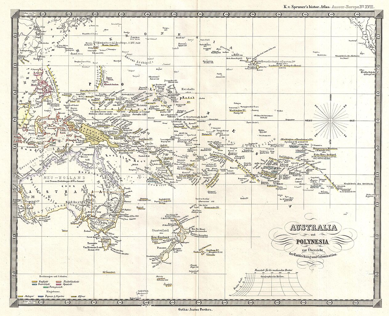
| Karl Spruner von Merz: Australia und Polynesia zur Ubersicht der Entdeckung und Colonisation
( |
||||||||||||||||||||
|---|---|---|---|---|---|---|---|---|---|---|---|---|---|---|---|---|---|---|---|---|
| 作者 |
|
|||||||||||||||||||
| タイトル |
Australia und Polynesia zur Ubersicht der Entdeckung und Colonisation |
|||||||||||||||||||
| 解説 |
English: This is Karl von Spruner’s 1855 historical map of Australia and Polynesia, with an overview of discoveries and colonization. Covers the area from Australia to California (in the upper right corner), and from China and Japan in the north to New Zealand, Auckland and Macquarie Islands in the south. Dates of discovery and discoverers names appear throughout, making this map is invaluable to anyone researching the history of discovery in Polynesia and Melanesia. Relief is shown by hachures, and the whole is rendered in finely engraved detail exhibiting throughout the fine craftsmanship for which the Perthes firm is best known. Justus Perthes published the map as plate number 18 in Dr. Karl von Spruner's 1855 Historisch-Geographischer Hand-Atlas zur Geschichte Asiens, Africa’s, America’s und Australiens , also known as Histor. Atlas. Ausser Europa . |
|||||||||||||||||||
| 日付 | 1855年 (undated) | |||||||||||||||||||
| 寸法 | 高さ: 12.2 in (31.1 cm);幅: 15 in (38.1 cm) | |||||||||||||||||||
| 台帳番号 |
Geographicus link: AustraliaPolynesia-spruner-1855 |
|||||||||||||||||||
| 情報源/撮影者 |
Spruner, Karl von, Historisch-Geographischer Hand-Atlas zur Geschichte Asiens, Africa's, America's und Australiens. (Gotha: Justus Perthes), 1855.
|
|||||||||||||||||||
| 許可 (ファイルの再利用) |
|
|||||||||||||||||||
| その他のバージョン | ||||||||||||||||||||

| 注釈 | この画像には注釈がついています: コモンズで注釈を見る |
ファイルの履歴
過去の版のファイルを表示するには、その版の日時をクリックしてください。
| 日付と時刻 | サムネイル | 寸法 | 利用者 | コメント | |
|---|---|---|---|---|---|
| 現在の版 | 2011年3月25日 (金) 07:42 | | 3,500 × 2,838 (1.88メガバイト) | BotMultichillT | {{subst:User:Multichill/Geographicus |link=http://www.geographicus.com/P/AntiqueMap/AustraliaPolynesia-spruner-1855 |product_name=1855 Spruner Map of Australia and Polynesia with an overview of Discoveries and Colonization |map_title=Australia und Polynes |
ファイルの使用状況
以下のページがこのファイルを使用しています:
グローバルなファイル使用状況
以下に挙げる他のウィキがこの画像を使っています:
- en.wikipedia.org での使用状況
- fr.wikipedia.org での使用状況