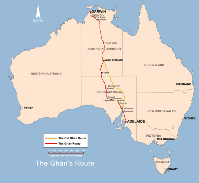
ファイル:The Ghan route map.png
表示

このプレビューのサイズ: 650 × 600 ピクセル。 その他の解像度: 260 × 240 ピクセル | 520 × 480 ピクセル | 832 × 768 ピクセル | 1,109 × 1,024 ピクセル | 1,300 × 1,200 ピクセル。
元のファイル (1,300 × 1,200 ピクセル、ファイルサイズ: 285キロバイト、MIME タイプ: image/png)
ファイルの履歴
過去の版のファイルを表示するには、その版の日時をクリックしてください。
| 日付と時刻 | サムネイル | 寸法 | 利用者 | コメント | |
|---|---|---|---|---|---|
| 現在の版 | 2008年12月2日 (火) 11:38 |  | 1,300 × 1,200 (285キロバイト) | Bidgee | Fix scale (Upload take 42) |
| 2008年12月2日 (火) 11:36 |  | 1,300 × 1,200 (288キロバイト) | Bidgee | Reverted to version as of 19:22, 13 June 2008 | |
| 2008年12月2日 (火) 10:57 | サムネイルなし | (285キロバイト) | Bidgee | Fix scale. | |
| 2008年6月13日 (金) 19:22 |  | 1,300 × 1,200 (288キロバイト) | Bidgee | Update {{ImageUpload|basic}} | |
| 2008年5月20日 (火) 09:39 |  | 1,200 × 1,121 (491キロバイト) | Bidgee | Correcting font sizes | |
| 2008年5月20日 (火) 09:06 |  | 1,200 × 1,121 (486キロバイト) | Bidgee | fix state and territory borders. | |
| 2008年5月20日 (火) 08:15 |  | 1,200 × 1,121 (415キロバイト) | Bidgee | Image fix | |
| 2008年5月20日 (火) 07:55 |  | 1,200 × 1,121 (415キロバイト) | Bidgee | {{Information |Description=The Ghan route map created by Bidgee based on other Ghan route maps on the internet which are low resolution and are not free to use. |Source=self-made |Date=20th May 2008 |Author= Bidgee |Permiss |
ファイルの使用状況
以下のページがこのファイルを使用しています:
グローバルなファイル使用状況
以下に挙げる他のウィキがこの画像を使っています:
- ca.wikipedia.org での使用状況
- en.wikipedia.org での使用状況
- en.wikivoyage.org での使用状況
- es.wikipedia.org での使用状況
- fi.wikipedia.org での使用状況
- fr.wikipedia.org での使用状況
- hi.wikipedia.org での使用状況
- hu.wikipedia.org での使用状況
- it.wikipedia.org での使用状況
- ko.wikipedia.org での使用状況
- ml.wikipedia.org での使用状況
- nl.wikipedia.org での使用状況
- pl.wikipedia.org での使用状況
- simple.wikipedia.org での使用状況
- sv.wikipedia.org での使用状況
- www.wikidata.org での使用状況
- zh.wikipedia.org での使用状況

