
ファイル:ZagrosMtns SaltDome ISS012-E-18774.jpg

元のファイル (1,000 × 673 ピクセル、ファイルサイズ: 277キロバイト、MIME タイプ: image/jpeg)
ウィキメディア・コモンズのファイルページにある説明を、以下に表示します。
|
概要
| 解説 |
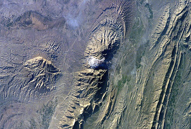
Astronaut photo of the southwestern edge of the Zagros Mountains featuring salt domes (the white section in the middle and the bump on the left). North is to the right. Text from NASA: The Zagros Mountains in southwestern Iran present an impressive landscape of long linear ridges and valleys. Formed by collision of the Eurasian and Arabian tectonic plates, the ridges and valleys extend hundreds of kilometers. Stresses induced in the Earth’s crust by the collision caused extensive folding of the preexisting layered sedimentary rocks. Subsequent erosion removed softer rocks, such as mudstone (rock formed by consolidated mud) and siltstone (a slightly coarser-grained mudstone) while leaving harder rocks, such as limestone (calcium-rich rock consisting of the remains of marine organisms) and dolomite (rocks similar to limestone containing calcium and magnesium). This differential erosion formed the linear ridges of the Zagros Mountains. The depositional environment and tectonic history of the rocks were conducive to the formation and trapping of petroleum, and the Zagros region is an important part of Persian Gulf production. This astronaut photograph of the southwestern edge of the Zagros mountain belt includes another common feature of the region—a salt dome (Kuh-e-Namak or “mountain of salt” in Farsi). Thick layers of minerals such as halite (common table salt) typically accumulate in closed basins during alternating wet and dry climatic conditions. Over geologic time, these layers of salt are buried under younger layers of rock. The pressure from overlying rock layers causes the lower-density salt to flow upwards, bending the overlying rock layers and creating a dome-like structure. Erosion has spectacularly revealed the uplifted tan and brown rock layers surrounding the white Kuh-e-Namak to the northwest and southeast (center of image). Radial drainage patterns indicate another salt dome is located to the southwest (image left center). If the rising plug of salt (called a salt diapir) breaches the surface, it can become a flowing salt glacier. Salt domes are an important target for oil exploration, as the impermeable salt frequently traps petroleum beneath other rock layers. |
| 日付 | |
| 原典 | http://earthobservatory.nasa.gov/Newsroom/NewImages/images.php3?img_id=17245 |
| 作者 | NASA |
| 許可 (ファイルの再利用) |
US government, public domain |
| 被写体の位置 | | 以下のサービスでこの位置を確認する: オープンストリートマップ |
|---|
ライセンス
This file is in the public domain in the United States because it was created by the Image Science & Analysis Laboratory, of the NASA Johnson Space Center. NASA copyright policy states that "NASA material is not protected by copyright unless noted". (NASA media use guidelines or Conditions of Use of Astronaut Photographs).
Photo source: ISS012-E-18774.
|
| 注釈 | この画像には注釈がついています: コモンズで注釈を見る |
ファイルの履歴
過去の版のファイルを表示するには、その版の日時をクリックしてください。
| 日付と時刻 | サムネイル | 寸法 | 利用者 | コメント | |
|---|---|---|---|---|---|
| 現在の版 | 2006年4月27日 (木) 16:31 | | 1,000 × 673 (277キロバイト) | Holly Cheng | {{Information | Description=Astronaut photo of the southwestern edge of the w:Zagros Mountains featuring w:salt domes (the white section in the middle and the bump on the left). | Source=http://earthobservatory.nasa.gov/Newsroom/NewImages/images.p |
ファイルの使用状況
以下のページがこのファイルを使用しています:
グローバルなファイル使用状況
以下に挙げる他のウィキがこの画像を使っています:
- ar.wikipedia.org での使用状況
- ceb.wikipedia.org での使用状況
- da.wikipedia.org での使用状況
- en.wikipedia.org での使用状況
- eo.wikipedia.org での使用状況
- es.wikipedia.org での使用状況
- fa.wikipedia.org での使用状況
- fr.wikipedia.org での使用状況
- hu.wikipedia.org での使用状況
- kk.wikipedia.org での使用状況
- lld.wikipedia.org での使用状況
- nl.wikipedia.org での使用状況
- pl.wikipedia.org での使用状況
- ro.wikipedia.org での使用状況
- ru.wikipedia.org での使用状況
- sh.wikipedia.org での使用状況
- sl.wikipedia.org での使用状況
- sr.wikipedia.org での使用状況
- uk.wikipedia.org での使用状況
- vi.wikipedia.org での使用状況
- www.wikidata.org での使用状況