
ファイル:WorldMapCosmasIndicopleustes.jpg
このプレビューのサイズ: 764 × 600 ピクセル。 その他の解像度: 306 × 240 ピクセル | 612 × 480 ピクセル | 979 × 768 ピクセル | 1,280 × 1,005 ピクセル | 1,539 × 1,208 ピクセル。
元のファイル (1,539 × 1,208 ピクセル、ファイルサイズ: 654キロバイト、MIME タイプ: image/jpeg)
ウィキメディア・コモンズのファイルページにある説明を、以下に表示します。
|
概要
| 解説 |
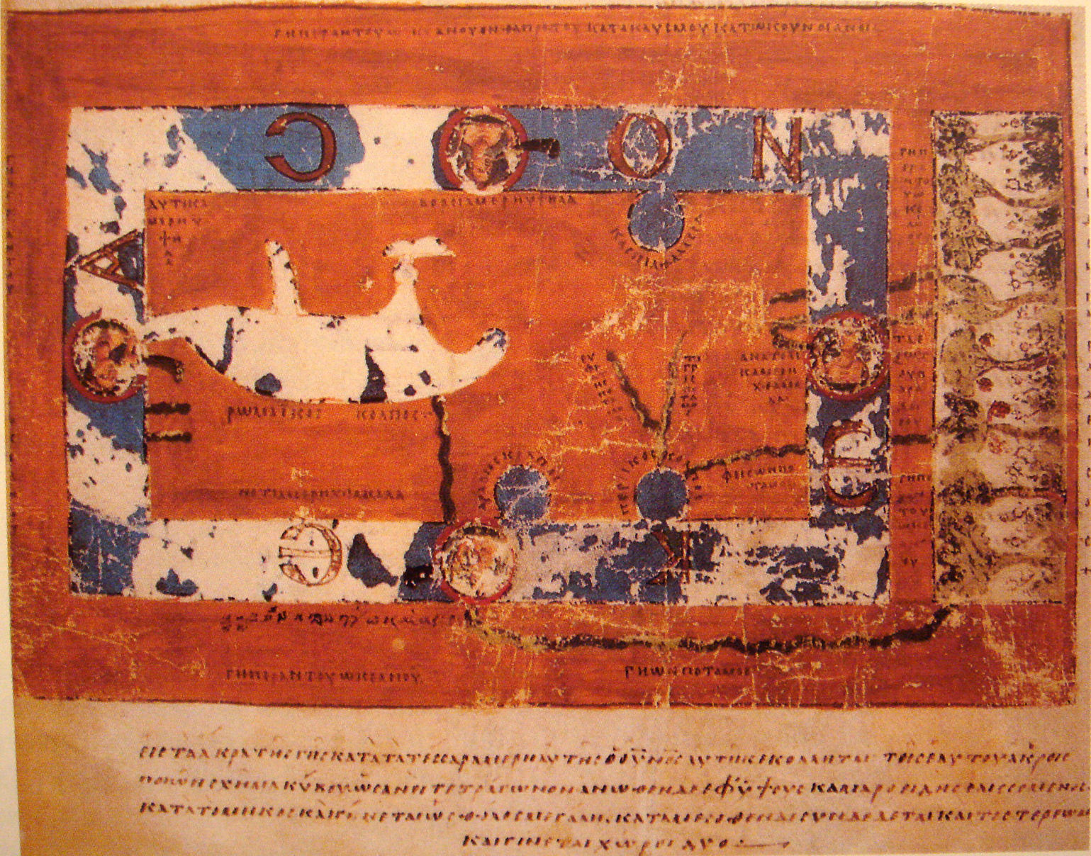
World Map by Cosmas Indicopleustes. The map is oriented with north to the top. It shows a rectangular landmass in the middle of the World Ocean ( ꙌΚΕΑΝΟϹ , Okeanos), reflecting what Cosmas thought was the "floor" of the tabernacle-shaped universe. The Roman Gulf (i.e., Mediterranean) is shown in the western half, with indentations for the unmarked Adriatic and Aegean/Black seas. Three further gulfs are shown: the Caspian to the northeast and the Arabian (i.e., Red Sea) and Persian gulfs to the south. Paradise is shown in the far east, beyond the Ocean. Four rivers run from it and cross under or through the Ocean to reach Asia and Africa. |
| 日付 | 6th century map. |
| 原典 | "Les Sciences au Moyen-Age", "Pour la Science" |
| 作者 | Cosmas Indicopleustes, 6th century |
| その他のバージョン |
|

ライセンス
|
このファイルは、パブリックドメインの状態にある平面的な美術の著作物を写真術によって忠実に複製したものです。このような複製はアメリカ合衆国においてパブリックドメインの状態にあります。その他の地域では再利用に制限がかかる場合があります。詳しくはReuse of PD-Art photographsをご覧ください。美術の著作物としての原図は、次の理由によりパブリックドメインの状態にあります。
{{PD-Art}} template without license parameter: please specify why the underlying work is public domain in both the source country and the United States
(Usage: {{PD-Art|1=|deathyear=''year of author's death''|country=''source country''}}, where parameter 1= can be PD-old-auto, PD-old-auto-expired, PD-old-auto-1996, PD-old-100 or similar. See Commons:Multi-license copyright tags for more information.) | ||||
| 注釈 | この画像には注釈がついています: コモンズで注釈を見る |
ファイルの履歴
過去の版のファイルを表示するには、その版の日時をクリックしてください。
| 日付と時刻 | サムネイル | 寸法 | 利用者 | コメント | |
|---|---|---|---|---|---|
| 現在の版 | 2007年11月16日 (金) 18:33 | | 1,539 × 1,208 (654キロバイト) | World Imaging | {{Information |Description=World Map by Cosmas Indicopleustes |Source="Les Sciences au Moyen-Age", "Pour la Science" |Date=6th century map. |Author=Cosmas Indicopleustes, 6th century |Permission= |other_versions= }} |
ファイルの使用状況
以下の 2 ページがこのファイルを使用しています:
グローバルなファイル使用状況
以下に挙げる他のウィキがこの画像を使っています:
- ar.wikipedia.org での使用状況
- ca.wikipedia.org での使用状況
- ceb.wikipedia.org での使用状況
- de.wikipedia.org での使用状況
- el.wikipedia.org での使用状況
- en.wikipedia.org での使用状況
- eo.wikipedia.org での使用状況
- es.wikipedia.org での使用状況
- fa.wikipedia.org での使用状況
- fa.wikibooks.org での使用状況
- fi.wikipedia.org での使用状況
- fr.wikipedia.org での使用状況
- gl.wikipedia.org での使用状況
- he.wikipedia.org での使用状況
- hr.wikipedia.org での使用状況
- id.wikipedia.org での使用状況
- it.wikipedia.org での使用状況
- it.wikiquote.org での使用状況
- ka.wikipedia.org での使用状況
- la.wikipedia.org での使用状況
- nl.wikipedia.org での使用状況
- pl.wikipedia.org での使用状況
- pt.wikipedia.org での使用状況
- ru.wikipedia.org での使用状況
このファイルのグローバル使用状況を表示する。