
ファイル:Western Empire-Europe870.JPG
高解像度版はありません。
Western_Empire-Europe870.JPG (428 × 317 ピクセル、ファイルサイズ: 83キロバイト、MIME タイプ: image/jpeg)
ウィキメディア・コモンズのファイルページにある説明を、以下に表示します。
|
概要
| 解説 |
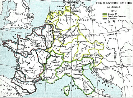
English: Frank king Charlemagne's kingdom survived the leader and covered much of Western Europe from 795 until 843 when a treaty split it amongst his grandsons: Central Franks ruled by w:Lothar I (green), East Franks ruled by w:Louis the German (yellow), and w:Charles the Bald led West Franks (purple). This particular map is from the Atlas to Freeman's Historical Geography, edited by J.B. Bury, Longmans Green and Co. Third Edition 1903. It is in the public domain and you may download it or print it for any use. |
| 日付 | |
| 原典 | Atlas To Freeman's Historical Geography |
| 作者 | J.B. Bury |
en.wikipedia からコモンズに Maksim によって移動されました。
元のファイルページはこちら。以下の利用者は全てen.wikipediaに属します。
元のアップロードログ ====
|
この著作物は、著作権の保護期間が著作者の死後70年以下である国・地域においてパブリックドメインの状態にあります。
| |
| このファイルは著作権法の既知の制約(隣接権や関連する権利を含む)から自由であると特定されています。 | |
ファイルの履歴
過去の版のファイルを表示するには、その版の日時をクリックしてください。
| 日付と時刻 | サムネイル | 寸法 | 利用者 | コメント | |
|---|---|---|---|---|---|
| 現在の版 | 2006年1月22日 (日) 14:21 | | 428 × 317 (83キロバイト) | Maksim | La bildo estas kopiita de wikipedia:en. La originala priskribo estas: Frank king Charlemagne's kingdom survived the leader and covered much of Western Europe from 795 until 843 when a treaty split it amongst his grandsons: Cen |
ファイルの使用状況
以下のページがこのファイルを使用しています:
グローバルなファイル使用状況
以下に挙げる他のウィキがこの画像を使っています:
- ar.wikipedia.org での使用状況
- ca.wikipedia.org での使用状況
- cs.wikipedia.org での使用状況
- da.wikipedia.org での使用状況
- de.wikipedia.org での使用状況
- en.wikipedia.org での使用状況
- eo.wikipedia.org での使用状況
- es.wikipedia.org での使用状況
- et.wikipedia.org での使用状況
- gl.wikipedia.org での使用状況
- it.wikipedia.org での使用状況
- la.wikipedia.org での使用状況
- no.wikipedia.org での使用状況
- pl.wikipedia.org での使用状況
- sh.wikipedia.org での使用状況
- simple.wikipedia.org での使用状況