
ファイル:US insular areas.png

元のファイル (1,482 × 624 ピクセル、ファイルサイズ: 39キロバイト、MIME タイプ: image/png)
ウィキメディア・コモンズのファイルページにある説明を、以下に表示します。
|

|
このファイルのベクター画像 (SVG) が利用できます。 使う目的に対し、元画像よりもSVGがより優れている場合、SVG画像を使用して下さい。
File:US insular areas.png → File:US insular areas.svg
|
 |
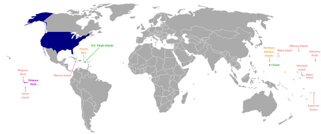
概要
This is a map of the US Insular areas. The first version of this map was based off Image:BlankMap-World-v6.png by User:Astrokey44 with the locations of a few islands added; the source for this are two CIA maps; the maps are a map of the Pacific region and a map of the United States Pacific Island Wildlife Refuges. Hawaii has also been added to the map. Names of the islands are from the CIA Factbook. The second version is based off Image:Dependent_territories_2007.png by User:Sesmith. This map is color-coded according to each island's status:
For an uncolor-coded map, see Image:US_insular_areas-B.png. For a version with the freely associated states, see Image:US_insular_areas FAS.png.
The previous map is under the GFDL; because of this, this map is also.
ライセンス

|
この文書は、フリーソフトウェア財団発行のGNUフリー文書利用許諾書 (GNU Free Documentation License) 1.2またはそれ以降のバージョンの規約に基づき、複製や再配布、改変が許可されます。不可変更部分、表紙、背表紙はありません。このライセンスの複製は、GNUフリー文書利用許諾書という章に含まれています。 |
| このファイルはクリエイティブ・コモンズ 表示-継承 3.0 非移植ライセンスのもとに利用を許諾されています。 | ||
| ||
| このライセンスのテンプレートは、GFDLのライセンス・アップデートによりこのファイルに追加されたものです。 |
ファイルの履歴
過去の版のファイルを表示するには、その版の日時をクリックしてください。
| 日付と時刻 | サムネイル | 寸法 | 利用者 | コメント | |
|---|---|---|---|---|---|
| 現在の版 | 2014年8月2日 (土) 06:35 | | 1,482 × 624 (39キロバイト) | KronosLine | Fix Ukraine, the Caucasus, and added South Sudan. |
| 2008年3月5日 (水) 04:52 |  | 1,482 × 624 (52キロバイト) | Hoshie | rebuilt using User:Sesmith's maps; more to come. | |
| 2007年3月17日 (土) 10:38 |  | 1,482 × 624 (32キロバイト) | Hoshie | This is a map of the US Insular areas. The base map is Image:BlankMap-World-v6.png by User:Astrokey44 with the locations of a few islands added; the source for this are two CIA maps; the maps are a [https://www.cia.gov/cia/publications/factbook/ |
ファイルの使用状況
このファイルを使用しているページはありません。
グローバルなファイル使用状況
以下に挙げる他のウィキがこの画像を使っています:
- ast.wikipedia.org での使用状況
- es.wikipedia.org での使用状況
- vi.wikipedia.org での使用状況
- www.wikidata.org での使用状況