
ファイル:US Overflight Fee Map.png
高解像度版はありません。
US_Overflight_Fee_Map.png (375 × 272 ピクセル、ファイルサイズ: 28キロバイト、MIME タイプ: image/png)
ウィキメディア・コモンズのファイルページにある説明を、以下に表示します。
|
概要
| 解説 |
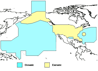
English: A map of the regions where the United States charges overflight fees. Yellow is where higher "enroute" fees are charged. Blue is where "oceanic" fees are charged. The colored regions of this map correspond to the regions where the US has delegated authority by the ICAO to control air traffic, including over international waters. |
| 日付 | 不明な日付 |
| 原典 | http://www.faa.gov/about/office_org/headquarters_offices/aba/overflight_fees/ |
| 作者 | Federal Aviation Administration |
ライセンス
This image or file is a work of a Federal Aviation Administration employee, taken or made as part of that person's official duties. As a work of the U.S. federal government, the image is in the public domain in the United States.
|
 |
ファイルの履歴
過去の版のファイルを表示するには、その版の日時をクリックしてください。
| 日付と時刻 | サムネイル | 寸法 | 利用者 | コメント | |
|---|---|---|---|---|---|
| 現在の版 | 2014年8月9日 (土) 02:52 | | 375 × 272 (28キロバイト) | AHeneen | User created page with UploadWizard |
ファイルの使用状況
以下のページがこのファイルを使用しています:
グローバルなファイル使用状況
以下に挙げる他のウィキがこの画像を使っています:
- af.wikipedia.org での使用状況
- en.wikipedia.org での使用状況
- fr.wikipedia.org での使用状況
- it.wikipedia.org での使用状況
- zh.wikipedia.org での使用状況