
ファイル:Tlingit-map.png
元のファイル (637 × 1,057 ピクセル、ファイルサイズ: 169キロバイト、MIME タイプ: image/png)
ウィキメディア・コモンズのファイルページにある説明を、以下に表示します。
|
info
(draft #1)
- created by en:User:ish ishwar in 2005
- released under CC-by-2.0
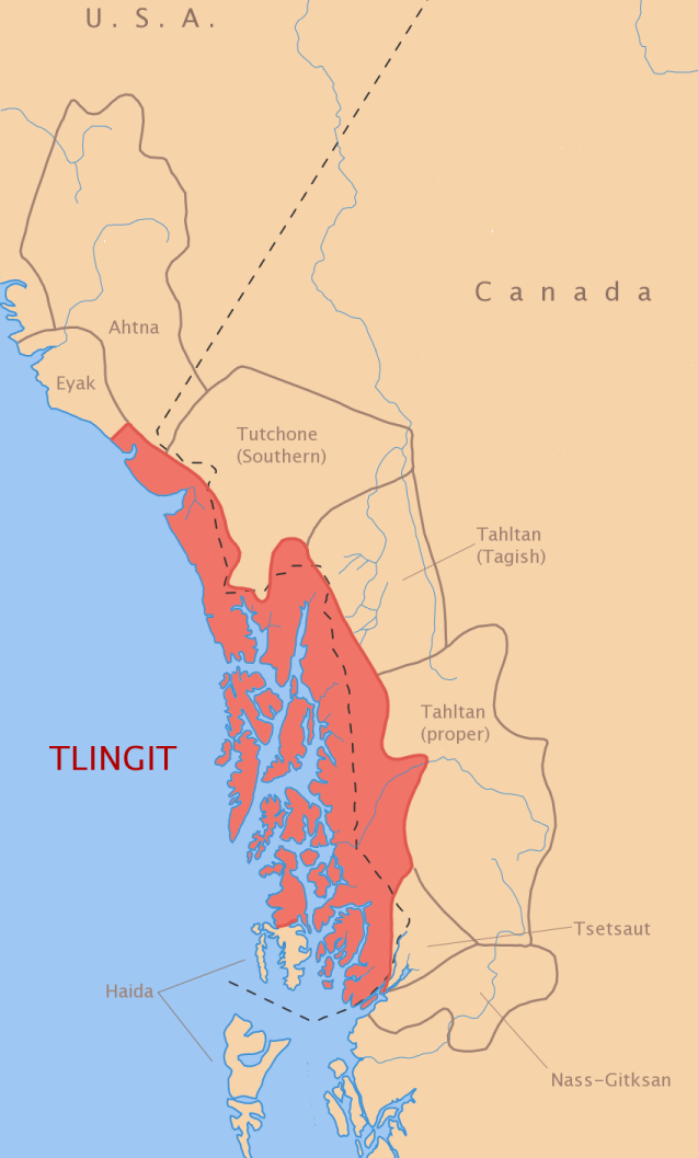
Map redrawn and modified from the map of North American Indian languages appearing in Goddard (1996) and as Goddard (1999).
- language areas are not as well-defined as this map would suggest: borders are often fuzzy and arbitrary and the entire language area may not be fully occupied by language speakers.
- many details, especially of rivers, lakes, & islands, have been omitted.
Goddard (1996, 1999) is a map of the entire North American continent and thus contains compromises concerning the full extent indigenous people's homelands. This is certainly the case with the Tlingit peoples (cf. also Chiricahua Apache). The majority of Tlingit-speaking peoples were coastal — this is shown in Goddard's maps. However, there were also Tlingit peoples further inland (called by such names as Inland Tlingit, Teslin, Atlin, Carcross). This inland area is not shown on Goddard's maps as the area overlaps with neighboring peoples (?). Since this map is currently based solely on Goddard (1996, 1999), it also does not display this area. This may be adjusted some time in future.
At this time the reader is recommended to compare this map with others listed in the bibliography below, esp.
- (Fig. 2) "Late 19th-early 20th Century territory with modern reserves" in McClellan (1981:471),
- overview map of the Subarctic culture area in Helm (1981:viii-xi).
- (Fig. 1) "Territories and former settlements of the Tlingit" in De Laguna (1990:204),
- overview map of the Northwest Coast culture area in Suttles (1990:viii-ix), and
- also concerning info about Inland Tlingit territory, see McClellan (1981:469-471).
note about neighbors:
The Tlingit peoples are surrounded by mostly Athabaskan speakers.
- Ahtna, Southern Tutchone, Tagish, Tahltan (proper), and Tsetsaut are Athabaskan (of the Na-Dene family).
- Eyak, a northern neighbor, is a Na-Dene language (although not Athabaskan).
- Nass-Gitksan is a Tsimshian language (which is not related to the Na-Dene family).
- Haida, who shares an island with Tlingit speakers, is a language isolate, unrelated to Na-Dene or Tsimshian families.
Tlingit itself is Na-Dene, related to Eyak and the Athabaskan languages.
to do
- show Inland Tlingit (see de Laguna 1991 and ANLC maps)
- show mixed Tlingit-Eyak area from Yakutat area to Cape Spencer (cf. ANLC map)
- label rivers and major lakes
- label major villages and towns
- Yakutat, Hoonah, Haines, Juneau, Sitka, Angoon, Wrangell, Kake, Klawock, Ketchikan
- possibly add borders of major Tlingit kwáan divisions?
- see Hope's Traditional Tlingit Country map
links
bibliography
- Campbell, Lyle. (1997). American Indian languages: The historical linguistics of Native America. New York: Oxford University Press. ISBN 0-19-509427-1.
- De Laguna, Frederica. (1990). Tlingit. In W. Suttles (Ed.), Northwest Coast (pp. 203-228). Handbook of North American Indians (Vol. 7). Washington, D.C.: Smithsonian Institution.
- Goddard, Ives (Ed.). (1996). Languages. Handbook of North American Indians (W. C. Sturtevant, General Ed.) (Vol. 17). Washington, D. C.: Smithsonian Institution. ISBN 0-1604-8774-9.
- Goddard, Ives. (1999). Native languages and language families of North America (rev. and enlarged ed. with additions and corrections). [Map]. Lincoln, NE: University of Nebraska Press (Smithsonian Institute). (Updated version of the map in Goddard 1996). ISBN 0-8032-9271-6.
- Helm, June (Ed.). (1981). Subartic. Handbook of Native American Indians (Vol. 6) (W. C. Sturtevant, General Ed.). Washington, D.C.: Smithsonian Institution.
- Krauss, Michael. (1982). Native peoples and languages of Alaska (rev. ed.). [Map]. Fairbanks, AK: Alaska Native Language Center. ISBN 0-933769-00-8.
- McClellan, Catharine. (1981). Inland Tlingit. In J. Helm (Ed.), Subarctic (pp. 469-480). Handbook of Native American Indians (Vol. 6). Washington, D.C.: Smithsonian Institution.
- Mithun, Marianne. (1999). The languages of Native North America. Cambridge: Cambridge University Press. ISBN 0-521-23228-7 (hbk); ISBN 0-521-29875-X.
- Sturtevant, William C. (Ed.). (1978-present). Handbook of North American Indians (Vol. 1-20). Washington, D. C.: Smithsonian Institution. (Vols. 1-3, 16, 18-20 not yet published).
- Suttles, Wayne (Ed.). (1990). Northwest Coast. Handbook of North American Indians (Vol. 7) (W. C. Sturtevant, General Ed.). Washington, D.C.: Smithsonian Institution.
- あなたは以下の条件に従う場合に限り、自由に
- 共有 – 本作品を複製、頒布、展示、実演できます。
- 再構成 – 二次的著作物を作成できます。
- あなたの従うべき条件は以下の通りです。
- 表示 – あなたは適切なクレジットを表示し、ライセンスへのリンクを提供し、変更があったらその旨を示さなければなりません。これらは合理的であればどのような方法で行っても構いませんが、許諾者があなたやあなたの利用行為を支持していると示唆するような方法は除きます。
ファイルの履歴
過去の版のファイルを表示するには、その版の日時をクリックしてください。
| 日付と時刻 | サムネイル | 寸法 | 利用者 | コメント | |
|---|---|---|---|---|---|
| 現在の版 | 2010年7月20日 (火) 05:01 | | 637 × 1,057 (169キロバイト) | Nvvchar | Cropped to reduce size |
| 2006年1月19日 (木) 04:41 |  | 768 × 1,590 (238キロバイト) | Ish ishwar | rv | |
| 2005年11月26日 (土) 22:24 |  | 180 × 373 (38キロバイト) | Walden69 | Mapa vikipedia english | |
| 2005年6月2日 (木) 02:49 |  | 768 × 1,590 (238キロバイト) | Ish ishwar | map of Tlingit and surrounding peoples |
ファイルの使用状況
以下の 2 ページがこのファイルを使用しています:
グローバルなファイル使用状況
以下に挙げる他のウィキがこの画像を使っています:
- av.wikipedia.org での使用状況
- be.wikipedia.org での使用状況
- ca.wikipedia.org での使用状況
- da.wikipedia.org での使用状況
- de.wikipedia.org での使用状況
- en.wikipedia.org での使用状況
- eo.wikipedia.org での使用状況
- es.wikipedia.org での使用状況
- et.wikipedia.org での使用状況
- eu.wikipedia.org での使用状況
- fa.wikipedia.org での使用状況
- fr.wikipedia.org での使用状況
- hr.wikipedia.org での使用状況
- hu.wikipedia.org での使用状況
- id.wikipedia.org での使用状況
- incubator.wikimedia.org での使用状況
- it.wikipedia.org での使用状況
- ko.wikipedia.org での使用状況
- lv.wikipedia.org での使用状況
- mrj.wikipedia.org での使用状況
- nl.wikipedia.org での使用状況
- no.wikipedia.org での使用状況
- pl.wikipedia.org での使用状況
このファイルのグローバル使用状況を表示する。