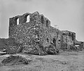
ファイル:The National Archives UK - CO 1069-34-50 1 001.jpg

ページのコンテンツが他言語でサポートされていません。

元のファイル(839 × 706 ピクセル、ファイルサイズ: 154キロバイト、MIME タイプ: image/jpeg)

概要

解説

This image is a copy of detail from File:The National Archives UK - CO 1069-34-50.jpg Description: Ruins of Fort Austenborg (Danish) at Jassy. (= The Ruins of Fort Augustaborg at Teshie in the contemporary Ghana.)

Location: Jassy (= Teshie)

Date:

Our Catalogue Reference: Part of CO 1069/34

This image is part of the Colonial Office photographic collection held at The National Archives, uploaded as part of the Africa Through a Lens project. Feel free to share it within the spirit of the Commons.

Our records about many of these images are limited. If you have more information about the people, places or events shown in an image, please use the comments section below. We have attempted to provide place information for the images automatically but our software may not have found the correct location.

Alternatively you could use the <a href='https://suggestify.appspot.com/'>Suggestify</a> tool to suggest the location of a picture.

For high quality reproductions of any item from our collection please contact our <a href='http://www.nationalarchives.gov.uk/imagelibrary' rel='nofollow'>image library</a>
日付 1890年代
date QS:P,+1890-00-00T00:00:00Z/8
(?)
原典

Africa Through a Lens

This file is from the collections of The National Archives (United Kingdom), catalogued under document record CO1069. For high quality reproductions of any item from The National Archives collection please contact the image library.

このタグは、添付された著作物の著作権状況を示すものではありません。通常の著作権タグも必要です。Commons:ライセンシングもご覧ください。


العربيَّة | English | français | italiano | македонски | +/−

作者 The National Archives UK - Flickr account
被写体の位置5° 35′ 00″ 北, 0° 06′ 00″ 西 Kartographer map based on OpenStreetMap.以下のサービスでこの位置を確認する: オープンストリートマップinfo

ライセンス

Royal Coat of Arms of the United Kingdom
このファイルは公開政府ライセンス1.0版OGL v1.0)の下に利用を許諾されています。
あなたは以下の条件に従う場合に限り、自由に
  • 情報を複製、公開、頒布、送信できます。
  • 情報を適応させることができます。
  • 情報を他の情報と組み合わせたり、独自の製品やアプリケーションに含めるなど、商業的に利用できます。
あなたの従うべき条件は以下の通りです。
  • 情報提供者が指定する帰属表示を含めることで、情報の出所を確認し、可能であれば、このライセンスへのリンクを提供しなければなりません。
  • 公的な地位を示唆するような方法で情報を使用したり、情報提供者があなたやあなたによる情報の使用を承認しているような方法で情報を使用してはなりません。
  • 他人を誤解させたり、情報やその出典を偽ったりしないようにしなければなりません。
  • あなたによる情報の使用が、1998年データ保護法又はプライバシー及び電子通信(EC命令)規則2003年に違反しないようにしなければなりません。

詳しくは、メタウィキの公開政府ライセンスのページをご覧ください。


Attribution information, such as the author's name, e-mail, website, or signature, that was once visible in the image itself has been moved into the image metadata and/or image description page. This makes the image easier to reuse and more language-neutral, and makes the text easier to process and search for. Commons discourages placing visible author information in images.

Indonesia | العربيَّة | Boarisch | беларуская (тарашкевіца)‎ | বাংলা | català | čeština | Deutsch | Ελληνικά | English | español | eesti | فارسی | suomi | français | עברית | magyar | italiano | 한국어 | македонски | മലയാളം | Plattdüütsch | Nederlands | polski | português | português do Brasil | русский | sicilianu | slovenščina | Türkçe | 中文 | +/−

キャプション

このファイルの内容を1行で記述してください

このファイルに描写されている項目

題材

5°34'59.999"N, 0°6'0.000"W

ファイルの履歴

過去の版のファイルを表示するには、その版の日時をクリックしてください。

日付と時刻サムネイル寸法利用者コメント
現在の版2015年8月25日 (火) 16:532015年8月25日 (火) 16:53時点における版のサムネイル839 × 706 (154キロバイト)Edithsmewatermark removed
2012年4月12日 (木) 17:232012年4月12日 (木) 17:23時点における版のサムネイル859 × 774 (165キロバイト)Katharinaivfirst trial of an improvement
2012年4月12日 (木) 17:192012年4月12日 (木) 17:19時点における版のサムネイル859 × 774 (107キロバイト)Katharinaiv{{Information |Description= This image is a copy of detail from File:The National Archives UK - CO 1069-34-50.jpg <b>Description:</b> Ruins of Fort Austenborg (Danish) at Jassy. ''(= The Ruins of Fort Augustaborg at Teshie in the contemporary Ghan...

以下のページがこのファイルを使用しています:

グローバルなファイル使用状況

以下に挙げる他のウィキがこの画像を使っています: