
ファイル:San Francisco earthquake.jpg
このプレビューのサイズ: 800 × 155 ピクセル。 その他の解像度: 320 × 62 ピクセル | 2,071 × 400 ピクセル。
元のファイル (2,071 × 400 ピクセル、ファイルサイズ: 315キロバイト、MIME タイプ: image/jpeg)
ウィキメディア・コモンズのファイルページにある説明を、以下に表示します。
|
概要
| 解説 |
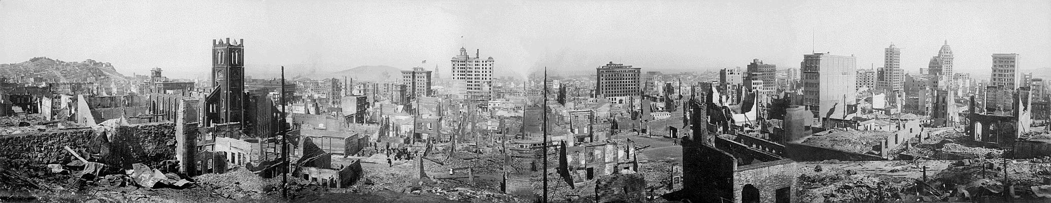
English: San Francisco earthquake 1906 - panoramic view
View of the destruction brought about by the San Francisco Earthquake, 1906 Records of the Office of the Chief Signal Officer (Army) (111-AGF-1-A-D) This is a composite panorama, meaning that it is pieced together from four separate images to give a panoramic effect. The photographer is unknown, though it may have been taken by the Army Signal Corps. It is printed on silver gelatin paper. The photo was taken from the site of the Stanford Mansion, later the Stanford Court hotel, on Powell Street, between California St. and Pine St. The square bell tower in the left frame is that of: Old Saint Mary's Church, 660 California, San Francisco, CA 94108 |
| 日付 | |
| 原典 |
National Archives and Records Administration Uploaded from : www.archives.gov |
| 作者 | 不明 |
| カメラの位置 | | 以下のサービスでこの位置を確認する: オープンストリートマップ |
|---|
このファイルは、アメリカ合衆国の連邦政府と雇用関係にある公務員がその職務上作成したアメリカ合衆国政府の著作物であり、アメリカ合衆国の著作権法上パブリックドメインに属します (17 U.S.C. §105)。
注意:このライセンスは、アメリカ合衆国政府の著作物についてのみ効力を有します。アメリカ合衆国の各州、郡、その他の地方自治体が作成した著作物に対しては適用できません。
|
 | |
| このファイルは著作権法の既知の制約(隣接権や関連する権利を含む)から自由であると特定されています。 | ||
ファイルの履歴
過去の版のファイルを表示するには、その版の日時をクリックしてください。
| 日付と時刻 | サムネイル | 寸法 | 利用者 | コメント | |
|---|---|---|---|---|---|
| 現在の版 | 2005年6月22日 (水) 14:50 | 2,071 × 400 (315キロバイト) | JoJan | San Francisco earthquake 1906 - panoramic view {{USGov-PD}} Uploaded from : [http://www.archives.gov/exhibit_hall/panoramic_photography/images/san_fran_earthquake.html] Credits : National Archives and Records Administration |
ファイルの使用状況
以下のページがこのファイルを使用しています:
グローバルなファイル使用状況
以下に挙げる他のウィキがこの画像を使っています:
- cs.wikipedia.org での使用状況
- da.wikipedia.org での使用状況
- de.wikipedia.org での使用状況
- en.wikipedia.org での使用状況
- et.wikipedia.org での使用状況
- frr.wikipedia.org での使用状況
- fr.wikipedia.org での使用状況
- ga.wikipedia.org での使用状況
- gd.wikipedia.org での使用状況
- hu.wikipedia.org での使用状況
- hy.wikipedia.org での使用状況
- hy.wiktionary.org での使用状況
- hyw.wikipedia.org での使用状況
- la.wikipedia.org での使用状況
- lb.wikipedia.org での使用状況
- lt.wikipedia.org での使用状況
- nds.wikipedia.org での使用状況
- nl.wikipedia.org での使用状況
- nrm.wikipedia.org での使用状況
- pl.wikipedia.org での使用状況
- pt.wikipedia.org での使用状況
- ro.wikipedia.org での使用状況
- sc.wikipedia.org での使用状況