
ファイル:SBIRS-GEO.jpg
高解像度版はありません。
SBIRS-GEO.jpg (265 × 190 ピクセル、ファイルサイズ: 25キロバイト、MIME タイプ: image/jpeg)
ウィキメディア・コモンズのファイルページにある説明を、以下に表示します。
|
| 解説 |
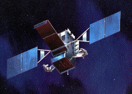
English: SPACE BASED INFRARED SYSTEMS (SBIRS)
SBIRS High features a mix of four geosynchronous earth orbit (GEO) satellites, two highly elliptical earth orbit (HEO) payloads, and associated ground hardware and software. SBIRS High will have both improved sensor flexibility and sensitivity. Sensors will cover short-wave infrared like its predecessor, expanded mid-wave infrared and see-to-the-ground bands allowing it to perform a broader set of missions as compared to DSP. Currently in the engineering, manufacturing, and development phase, the first SBIRS High HEO payload is scheduled for delivery in 2003 and the first GEO satellite is expected to launch in 2006 |
| 原典 | http://www.losangeles.af.mil/library/factsheets/factsheet_media.asp?fsID=5330 |
| 作者 | US Air Force |
|
|
 |
ファイルの履歴
過去の版のファイルを表示するには、その版の日時をクリックしてください。
| 日付と時刻 | サムネイル | 寸法 | 利用者 | コメント | |
|---|---|---|---|---|---|
| 現在の版 | 2008年6月22日 (日) 10:21 | | 265 × 190 (25キロバイト) | GDK | {{Information |Description={{en|1=SPACE BASED INFRARED SYSTEMS (SBIRS) SBIRS High features a mix of four geosynchronous earth orbit (GEO) satellites, two highly elliptical earth orbit (HEO) payloads, and associated ground hardware and software. SBIRS High |
ファイルの使用状況
以下のページがこのファイルを使用しています:
グローバルなファイル使用状況
以下に挙げる他のウィキがこの画像を使っています:
- de.wikipedia.org での使用状況
- en.wikipedia.org での使用状況
- et.wikipedia.org での使用状況
- it.wikipedia.org での使用状況
- ko.wikipedia.org での使用状況
- pt.wikipedia.org での使用状況
- ru.wikipedia.org での使用状況
- tr.wikipedia.org での使用状況
- uk.wikipedia.org での使用状況