
ファイル:Orbits around earth scale diagram.svg

この SVG ファイルのこの PNG プレビューのサイズ: 600 × 600 ピクセル. その他の解像度: 240 × 240 ピクセル | 480 × 480 ピクセル | 768 × 768 ピクセル | 1,024 × 1,024 ピクセル | 2,048 × 2,048 ピクセル | 4,300 × 4,300 ピクセル。
元のファイル (SVG ファイル、4,300 × 4,300 ピクセル、ファイルサイズ: 5キロバイト)
ウィキメディア・コモンズのファイルページにある説明を、以下に表示します。
|
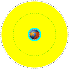
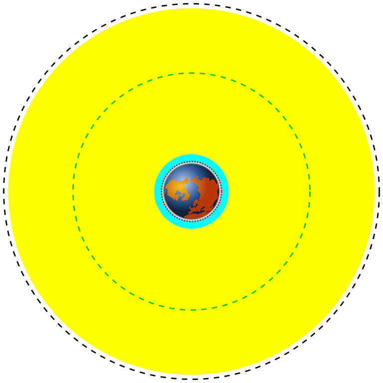
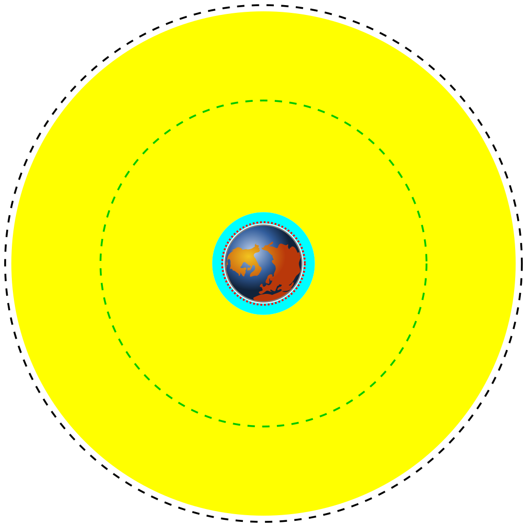
| English | Deutsch | Français | తెలుగు | Marker | Distance above earth (km) | Distance from center of earth (km) |
|---|---|---|---|---|---|---|
| Earth | Erde | Terre | భూమి | Blue/brown image | 0 | 6370 |
| Low Earth Orbit (LEO) | Low Earth Orbit | Orbite terrestre basse | భూ నిమ్న కక్ష్య | Cyan area | 160 to 2,000 | 6,530 to 8,370 |
| Medium Earth Orbit (MEO) | Medium Earth Orbit | Orbite moyenne de la terre | భూ మధ్యస్థ కక్ష్య | Yellow area | 2,000 to 34,780 | 8,370 to 41,150 |
| International Space Station (ISS) | Internationale Raumstation | Station spatiale internationale | అంతర్జాతీయ అంతరిక్ష కేంద్రం | Red dotted line | 370 | 6,741 |
| Global Positioning System (GPS) satellites | Globales Positionsbestimmungssystem | Système de positionnement mondial | గ్లోబల్ పొజిషనింగ్ వ్యవస్థ | Green dash-dot line | 20,230 | 26,600 |
| Geostationary Orbit (GEO) | Geostationäre Umlaufbahn | Orbite géostationnaire | భూ స్థిర కక్ష్య | Black dashed line | 35,794 | 42,164 |
| 解説 |
English: A scale diagram showing earth and various orbits above it.
Deutsch: Skalendiagramm der Erde und verschiedener Umlaufbahnen.
Français : Diagramme échelle montrant la terre et des orbites.
తెలుగు: భూమిని, భూ కక్ష్యలను చూపే ప్రామాణిక చిత్రం. |
||
| 日付 | |||
| 原典 | Created by Commons user Mike1024, Earth based on File:Worldmap northern.svg | ||
| 作者 | Image of earth: Gringer. Scale orbits: Mike1024 | ||
| 許可 (ファイルの再利用) |
This image is based on a public domain image (File:Worldmap northern.svg) and is released into the public domain.
|
12121
ファイルの履歴
過去の版のファイルを表示するには、その版の日時をクリックしてください。
| 日付と時刻 | サムネイル | 寸法 | 利用者 | コメント | |
|---|---|---|---|---|---|
| 現在の版 | 2014年3月30日 (日) 19:06 | | 4,300 × 4,300 (5キロバイト) | XZise | fixed rotation of Earth (is now looking from above) |
| 2014年3月30日 (日) 15:27 |  | 4,300 × 4,300 (3キロバイト) | XZise | manually rewritten from scratch thus dramatically reduced file size | |
| 2008年1月16日 (水) 23:19 |  | 3,009 × 3,009 (19キロバイト) | Mike1024 | {| class="wikitable" style="text-align:center" |- ! English !! Deutsch !! Français !! Marker !! Distance above earth (km) |!!Distance from center of earth (km) |- ! Earth !! Erde !! Terre | Blue/brown image || 0 | |
ファイルの使用状況
グローバルなファイル使用状況
以下に挙げる他のウィキがこの画像を使っています:
- ar.wikipedia.org での使用状況
- ast.wikipedia.org での使用状況
- bn.wikipedia.org での使用状況
- ca.wikipedia.org での使用状況
- cs.wikipedia.org での使用状況
- da.wikipedia.org での使用状況
- de.wikipedia.org での使用状況
- el.wikipedia.org での使用状況
- en.wikipedia.org での使用状況
- en.wikiversity.org での使用状況
- eo.wikipedia.org での使用状況
- es.wikipedia.org での使用状況
- et.wikipedia.org での使用状況
- eu.wikipedia.org での使用状況
- fa.wikipedia.org での使用状況
- fi.wikipedia.org での使用状況
- fr.wikipedia.org での使用状況
- gu.wikipedia.org での使用状況
- he.wikipedia.org での使用状況
- hi.wikipedia.org での使用状況
- hr.wikipedia.org での使用状況
このファイルのグローバル使用状況を表示する。