
ファイル:ORD Airport Diagram.svg

この SVG ファイルのこの PNG プレビューのサイズ: 390 × 599 ピクセル. その他の解像度: 156 × 240 ピクセル | 313 × 480 ピクセル | 500 × 768 ピクセル | 667 × 1,024 ピクセル | 1,334 × 2,048 ピクセル | 484 × 743 ピクセル。
元のファイル (SVG ファイル、484 × 743 ピクセル、ファイルサイズ: 3.46メガバイト)
ウィキメディア・コモンズのファイルページにある説明を、以下に表示します。
|
概要
| 解説 |
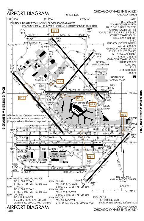
English: FAA Airport Diagram of O'Hare International Airport. |
| 日付 | |
| 原典 |
FAA Airport Diagrams; note that these change every 28 days. Taken from PDF on FAA site and converted to SVG using en:Wikipedia:How to draw SVG circuits using Xcircuit. |
| 作者 | Produced by the National Aeronautical Charting Office (NACO), a department of the United States en:Federal Aviation Administration. |
| カメラの位置 | | 以下のサービスでこの位置を確認する: オープンストリートマップ |
|---|
W3C-validity not checked.
ライセンス
This image or file is a work of a Federal Aviation Administration employee, taken or made as part of that person's official duties. As a work of the U.S. federal government, the image is in the public domain in the United States.
|
 |
ファイルの履歴
過去の版のファイルを表示するには、その版の日時をクリックしてください。
| 日付と時刻 | サムネイル | 寸法 | 利用者 | コメント | |
|---|---|---|---|---|---|
| 現在の版 | 2015年10月15日 (木) 21:27 | | 484 × 743 (3.46メガバイト) | BorgHunter | New diagram with 10R/28L |
| 2014年11月8日 (土) 14:36 |  | 484 × 743 (1.63メガバイト) | BorgHunter | Updated diagram includes runway 28C | |
| 2013年5月2日 (木) 14:02 |  | 378 × 547 (1.62メガバイト) | Grendelkhan | SVG version of FAA's PDF diagram. |
ファイルの使用状況
以下のページがこのファイルを使用しています:
グローバルなファイル使用状況
以下に挙げる他のウィキがこの画像を使っています:
- ar.wikipedia.org での使用状況
- de.wikipedia.org での使用状況
- en.wikipedia.org での使用状況
- eo.wikipedia.org での使用状況
- fr.wikipedia.org での使用状況
- hi.wikipedia.org での使用状況
- it.wikipedia.org での使用状況
- ko.wikipedia.org での使用状況
- pl.wikipedia.org での使用状況
- ru.wikipedia.org での使用状況
- sk.wikipedia.org での使用状況
- sl.wikipedia.org での使用状況
- th.wikipedia.org での使用状況
- www.wikidata.org での使用状況