
ファイル:New-Map-Francophone World.PNG

このプレビューのサイズ: 800 × 441 ピクセル。 その他の解像度: 320 × 176 ピクセル | 640 × 353 ピクセル | 1,024 × 564 ピクセル | 1,280 × 705 ピクセル | 2,664 × 1,468 ピクセル。
元のファイル (2,664 × 1,468 ピクセル、ファイルサイズ: 93キロバイト、MIME タイプ: image/png)
ウィキメディア・コモンズのファイルページにある説明を、以下に表示します。
|
概要
| 解説 |
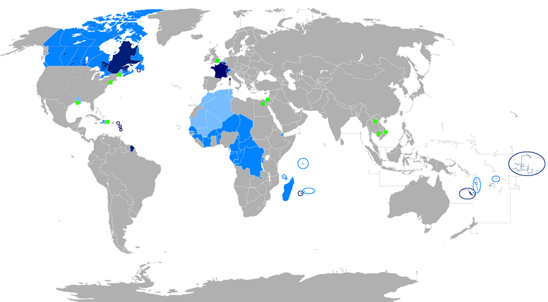
English: The French language and French creoles in the world
Regions where French or a French creole is the main language
Regions where it is an official language
Regions where it is a second language
Regions where it is a minority language
The following things have been changed from the old "Map-Francophone World.PNG":
To be modified :
Français : La langue française dans le monde
Langue maternelle
Langue officielle
Deuxième langue
Minorités francophones
Les choses suivantes ont été modifiées de l'ancien "Map-Frncophone World.PNG":
Proposition de modification : L'usage de la langue française est divers dans les pays d'Afrique subsaharienne. Par exemple, le français n'est pas la langue utilisée par défaut dans les rues sénégalaises. Tout au contraire, prétendre que le français n'est pas la langue maternelle des Gabonais reviendrait à dire que le français n'était rien de plus qu'une langue officielle dans la Bretagne des années cinquante. Ne connaissant pas la situation des autres pays, je laisse le soin à toute personne motivée de corriger cette erreur.
Català: La llengua francesa al món
Llengua materna
Llengua oficial
Segona Llengua
Minories francòfones |
| 日付 | |
| 原典 | 投稿者自身による著作物 |
| 作者 | aaker |

|
このファイルのベクター画像 (SVG) が利用できます。 使う目的に対し、元画像よりもSVGがより優れている場合、SVG画像を使用して下さい。
File:New-Map-Francophone World.PNG → File:New-Map-Francophone World.svg
|
 |
ライセンス
| この著作物の著作権者である私は、この著作物における権利を放棄しパブリックドメインとします。これは全世界で適用されます。 一部の国では、これが法的に可能ではない場合があります。その場合は、次のように宣言します。 私は、あらゆる人に対して、法により必要とされている条件を除き、如何なる条件も課すことなく、あらゆる目的のためにこの著作物を使用する権利を与えます。 |
ファイルの履歴
過去の版のファイルを表示するには、その版の日時をクリックしてください。
| 日付と時刻 | サムネイル | 寸法 | 利用者 | コメント | |
|---|---|---|---|---|---|
| 現在の版 | 2023年7月30日 (日) 00:15 | | 2,664 × 1,468 (93キロバイト) | Riad Salih | Western Sahara is an old Spanish colony, and French is not commonly used there. |
| 2023年7月30日 (日) 00:10 |  | 2,664 × 1,468 (93キロバイト) | Riad Salih | Since July 2023, French is no longer an official language in Mali, but a language of work. | |
| 2023年4月30日 (日) 06:49 |  | 2,664 × 1,468 (205キロバイト) | Moalli | Remove green square in middle of Mediterranean, no country located there | |
| 2023年3月15日 (水) 22:50 |  | 2,664 × 1,468 (105キロバイト) | Kwamikagami | update some per WP-en article, though this map not used much anymore | |
| 2019年8月9日 (金) 10:21 |  | 2,664 × 1,468 (120キロバイト) | Benderban01 | Reverted to version as of 15:28, 17 July 2018 (UTC) | |
| 2019年8月6日 (火) 09:07 |  | 2,664 × 1,468 (119キロバイト) | Benderban01 | Removed the small thing on ontario. | |
| 2019年8月6日 (火) 09:01 |  | 2,664 × 1,468 (119キロバイト) | Benderban01 | Removed 8 provinces where french is not the official language, there 3 territorries which will spoke minority. | |
| 2018年7月17日 (火) 15:28 |  | 2,664 × 1,468 (120キロバイト) | Maphobbyist | Reverted to version as of 18:46, 4 January 2018 (UTC) | |
| 2018年6月27日 (水) 09:53 |  | 2,664 × 1,468 (100キロバイト) | Motiss | ||
| 2018年6月27日 (水) 09:50 |  | 2,664 × 1,468 (120キロバイト) | Motiss | Reverted to version as of 18:46, 4 January 2018 (UTC) |
ファイルの使用状況
このファイルを使用しているページはありません。
グローバルなファイル使用状況
以下に挙げる他のウィキがこの画像を使っています:
- de.wikipedia.org での使用状況
- en.wikipedia.org での使用状況
- Category:Wikipedians in Luxembourg
- Category:Wikipedians in Switzerland
- Category:WikiProject Luxembourg participants
- Category:WikiProject Switzerland participants
- Category:Swiss Wikipedians
- Talk:English language/Archive 18
- Talk:French language/Archive 3
- Category:Wikipedians interested in Luxembourg
- Category:Wikipedians interested in Switzerland
- Category:Luxembourg Wikipedians
- Template:Portal/doc/all
- Wikipedia:Reference desk/Archives/Humanities/2013 October 5
- User:Matt Fitzpatrick/portal images
- Wikipedia:Userboxes/Location/Luxembourg
- Wikipedia:Userboxes/Location/Switzerland
- Template:User Luxembourg/cat
- Template:User Switzerland/cat
- Template:User Luxembourg/boxes
- Template:User Switzerland/boxes
- es.wikipedia.org での使用状況
- fi.wikipedia.org での使用状況
- fr.wikipedia.org での使用状況
- Discussion:Francophonie
- Discussion utilisateur:Le sotré
- Liste des pays ayant le français pour langue officielle
- Wikipédia:Le Bistro/24 février 2008
- Utilisateur:Brochon99/Bac à sable 5/Documentation
- Wikipédia:Le Bistro/18 décembre 2009
- Utilisateur:Kimdime/stats
- Utilisateur:Ygdrasil/http://Liste langue par nbr locuteur
- Utilisateur:Televido/Récolte
- Wikipédia:Le Bistro/25 juillet 2017
- Wikipédia:Le Bistro/30 juillet 2017
- fr.wikinews.org での使用状況
- fr.wiktionary.org での使用状況
- jv.wikipedia.org での使用状況
- km.wikipedia.org での使用状況
- nl.wikipedia.org での使用状況
- so.wikipedia.org での使用状況
- tum.wikipedia.org での使用状況