
ファイル:NUTS 3 regions of Northern Ireland map.svg

この SVG ファイルのこの PNG プレビューのサイズ: 705 × 599 ピクセル. その他の解像度: 282 × 240 ピクセル | 565 × 480 ピクセル | 903 × 768 ピクセル | 1,205 × 1,024 ピクセル | 2,409 × 2,048 ピクセル | 1,208 × 1,027 ピクセル。
元のファイル (SVG ファイル、1,208 × 1,027 ピクセル、ファイルサイズ: 163キロバイト)
ウィキメディア・コモンズのファイルページにある説明を、以下に表示します。
|
概要
| 解説 |
Deutsch: Karte von Nordirland: NUTS-Raumeinheiten auf den Ebenen NUTS3.
Quadratische Plattkarte, N-S-Streckung 170 %. Geographische Begrenzung der Karte:
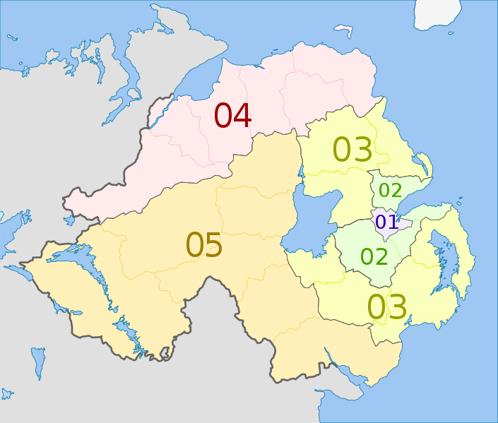
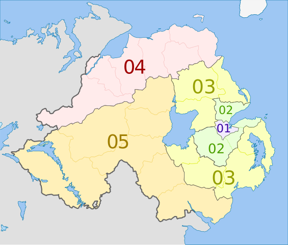
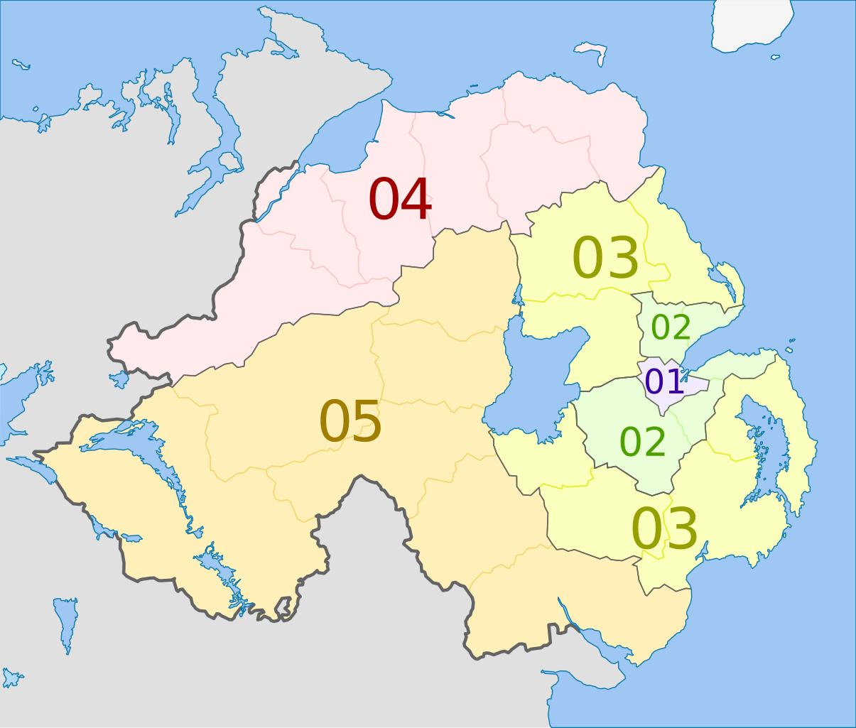
English: Map of the NUTS 3 regions of Northern Ireland.
Equirectangular projection, N/S stretching 170 %. Geographic limits of the map:
|
| 日付 | (UTC) |
| 原典 |
このファイルの派生元: Northern Ireland location map.svg: |
| 作者 |
|
| NUTS 1 | Code | NUTS 2 | Code | NUTS 3 | Code |
|---|---|---|---|---|---|
| Northern Ireland | UKN | Northern Ireland | UKN0 | Belfast | UKN01 |
| Outer Belfast (Carrickfergus, Castlereagh, Lisburn, Newtownabbey, North Down) | UKN02 | ||||
| East of Northern Ireland (Antrim, Ards, Ballymena, Banbridge, Craigavon, Down, Larne) | UKN03 | ||||
| North of Northern Ireland (Ballymoney, Coleraine, Derry, Limavady, Moyle, Strabane) | UKN04 | ||||
| West and South of Northern Ireland (Armagh, Cookstown, Dungannon, Fermanagh, Magherafelt, Newry and Mourne, Omagh) | UKN05 |
ライセンス
この作品の著作権者である私は、この作品を以下のライセンスで提供します。
このファイルはクリエイティブ・コモンズ 表示-継承 3.0 非移植ライセンスのもとに利用を許諾されています。
帰属: Dr Greg and NordNordWest
- あなたは以下の条件に従う場合に限り、自由に
- 共有 – 本作品を複製、頒布、展示、実演できます。
- 再構成 – 二次的著作物を作成できます。
- あなたの従うべき条件は以下の通りです。
- 表示 – あなたは適切なクレジットを表示し、ライセンスへのリンクを提供し、変更があったらその旨を示さなければなりません。これらは合理的であればどのような方法で行っても構いませんが、許諾者があなたやあなたの利用行為を支持していると示唆するような方法は除きます。
- 継承 – もしあなたがこの作品をリミックスしたり、改変したり、加工した場合には、あなたはあなたの貢献部分を元の作品とこれと同一または互換性があるライセンスの下に頒布しなければなりません。
元のアップロードログ
This image is a derivative work of the following images:
- File:Northern_Ireland_location_map.svg licensed with Cc-by-sa-3.0
- 2009-09-22T18:02:38Z NordNordWest 1208x1027 (166284 Bytes)
- 2009-07-04T20:14:31Z NordNordWest 1208x1027 (167876 Bytes)
- 2009-07-04T20:10:20Z NordNordWest 1208x1027 (167239 Bytes) {{Information |Description= {{de|Positionskarte von [[:de:Nordirland|Nordirland]]}} Quadratische Plattkarte, N-S-Streckung 170 %. Geographische Begrenzung der Karte: * N: 55.4° N * S: 53.9° N * W: 8.3° W * O: 5.3° W {{en|
Uploaded with derivativeFX
ファイルの履歴
過去の版のファイルを表示するには、その版の日時をクリックしてください。
| 日付と時刻 | サムネイル | 寸法 | 利用者 | コメント | |
|---|---|---|---|---|---|
| 現在の版 | 2012年6月5日 (火) 00:20 | | 1,208 × 1,027 (163キロバイト) | Dr Greg | == {{int:filedesc}} == {{Information |Description={{de|Karte von Nordirland: de:NUTS-Raumeinheiten auf den Ebenen NUTS3. Quadratische Plattkarte, N-S-Streckung 170 %. Geographische Begrenzung der Karte: * N: 55.4° N * S: ... |
ファイルの使用状況
以下のページがこのファイルを使用しています:
グローバルなファイル使用状況
以下に挙げる他のウィキがこの画像を使っています:
- ar.wikipedia.org での使用状況
- de.wikipedia.org での使用状況
- en.wikipedia.org での使用状況
- fi.wikipedia.org での使用状況
- it.wikipedia.org での使用状況
- lt.wikipedia.org での使用状況
- ru.wikipedia.org での使用状況
- uk.wikipedia.org での使用状況
- zh.wikipedia.org での使用状況