
ファイル:NC Punt.jpg
高解像度版はありません。
NC_Punt.jpg (400 × 400 ピクセル、ファイルサイズ: 77キロバイト、MIME タイプ: image/jpeg)
ウィキメディア・コモンズのファイルページにある説明を、以下に表示します。
|
概要
| 解説 |
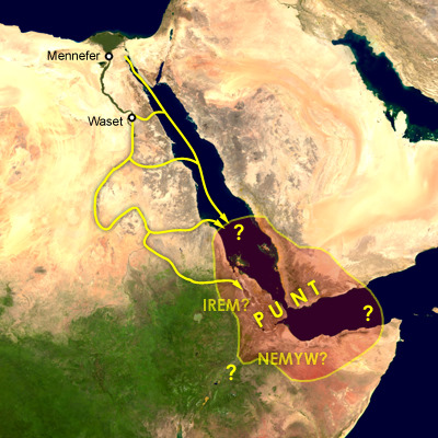
English: Map of the supposed location of Punt and trade routes from Egypt to Punt via rivers, wadis, and by sea. Mennefer is Memphis, Waset is Thebes, Irem and Nemyw are lands that supposedly border on Punt |
| 日付 | 2009年11月30日 (当初のアップロード日) |
| 原典 | en.wikipedia からコモンズに移動されました。 |
| 作者 | 英語版ウィキペディアのCushさん |
ライセンス
| この著作物は、著作者である英語版ウィキペディアのCushさんによって権利が放棄され、パブリックドメインとされました。これは全世界で適用されます。 一部の国では、これが法的に可能ではない場合があります。その場合は、次のように宣言します。 Cushは、あらゆる人に対して、法により必要とされている条件を除き、如何なる条件も課すことなく、あらゆる目的のためにこの著作物を使用する権利を与えます。 |
This compound image uses free material land_shallow_topo_east.tif from NASA Visible Earth (formerly "Blue Marble") and world.200407.3x21600x21600.C1.png from JULY, BLUE MARBLE NEXT GENERATION
元のアップロードログ
元のファイルページはこちら。以下の利用者は全てen.wikipediaに属します。
- 2009-11-30 00:57 Cush 400×400× (79081 bytes) Map of the supposed location of Punt
ファイルの履歴
過去の版のファイルを表示するには、その版の日時をクリックしてください。
| 日付と時刻 | サムネイル | 寸法 | 利用者 | コメント | |
|---|---|---|---|---|---|
| 現在の版 | 2023年10月22日 (日) 03:33 | | 400 × 400 (77キロバイト) | Cush | Reverted to version as of 13:38, 28 February 2011 (UTC) Punt is considered to be on either side of the Bab-el-Mandeb |
| 2023年9月29日 (金) 15:37 |  | 400 × 400 (68キロバイト) | Bidiieyahaneko | Due weight, majority of scholarly sources place Punt in Africa | |
| 2011年2月28日 (月) 13:38 |  | 400 × 400 (77キロバイト) | Freetrashbox | {{Information |Description={{en|Map of the supposed location of Punt}} |Source=Transferred from [http://en.wikipedia.org en.wikipedia] |Date={{Date|2009|11|30}} (original upload date) |Author=Original uploader was Cush at [http://en.wiki |
ファイルの使用状況
以下のページがこのファイルを使用しています:
グローバルなファイル使用状況
以下に挙げる他のウィキがこの画像を使っています:
- am.wikipedia.org での使用状況
- ar.wikipedia.org での使用状況
- bn.wikipedia.org での使用状況
- ca.wikipedia.org での使用状況
- en.wikipedia.org での使用状況
- en.wiktionary.org での使用状況
- es.wikipedia.org での使用状況
- fr.wikipedia.org での使用状況
- hu.wikipedia.org での使用状況
- lv.wikipedia.org での使用状況
- ru.wikipedia.org での使用状況
- ru.wiktionary.org での使用状況
- simple.wikipedia.org での使用状況
- sr.wikipedia.org での使用状況