
ファイル:Map of USA DE.svg

この SVG ファイルのこの PNG プレビューのサイズ: 286 × 186 ピクセル. その他の解像度: 320 × 208 ピクセル | 640 × 416 ピクセル | 1,024 × 666 ピクセル | 1,280 × 832 ピクセル | 2,560 × 1,665 ピクセル。
元のファイル (SVG ファイル、286 × 186 ピクセル、ファイルサイズ: 167キロバイト)
ウィキメディア・コモンズのファイルページにある説明を、以下に表示します。
|
Clickable version
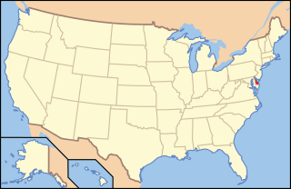
| 解説 | Map of USA with Delaware highlighted |
| 原典 |
Modified version of United States (Outline Map) 1998 from Perry-Castañeda Library Map Collection: United States Maps |
| 作者 | Huebi |
| その他のバージョン | image:Map of USA with state names.svg |
| このファイルはクリエイティブ・コモンズ 表示-継承 3.0 非移植ライセンスのもとに利用を許諾されています。 著作権に示した解釈の下ライセンスされるものとします。 | ||
| ||
| このライセンスのテンプレートは、GFDLのライセンス・アップデートによりこのファイルに追加されたものです。 |

|
この文書は、フリーソフトウェア財団発行のGNUフリー文書利用許諾書 (GNU Free Documentation License) 1.2またはそれ以降のバージョンの規約に基づき、複製や再配布、改変が許可されます。不可変更部分、表紙、背表紙はありません。このライセンスの複製は、GNUフリー文書利用許諾書という章に含まれています。 著作権に示した解釈の下ライセンスされるものとします。 |
このファイルはクリエイティブ・コモンズ 表示 2.0 一般ライセンスのもとに利用を許諾されています。
- あなたは以下の条件に従う場合に限り、自由に
- 共有 – 本作品を複製、頒布、展示、実演できます。
- 再構成 – 二次的著作物を作成できます。
- あなたの従うべき条件は以下の通りです。
- 表示 – あなたは適切なクレジットを表示し、ライセンスへのリンクを提供し、変更があったらその旨を示さなければなりません。これらは合理的であればどのような方法で行っても構いませんが、許諾者があなたやあなたの利用行為を支持していると示唆するような方法は除きます。
このファイルはクリエイティブ・コモンズ 表示-継承 1.0 一般ライセンスのもとに利用を許諾されています。
- あなたは以下の条件に従う場合に限り、自由に
- 共有 – 本作品を複製、頒布、展示、実演できます。
- 再構成 – 二次的著作物を作成できます。
- あなたの従うべき条件は以下の通りです。
- 表示 – あなたは適切なクレジットを表示し、ライセンスへのリンクを提供し、変更があったらその旨を示さなければなりません。これらは合理的であればどのような方法で行っても構いませんが、許諾者があなたやあなたの利用行為を支持していると示唆するような方法は除きます。
- 継承 – If you alter, transform, or build upon this work, you must distribute the resulting work under the same license as the original.
このファイルはクリエイティブ・コモンズ 表示-継承 2.0 一般ライセンスのもとに利用を許諾されています。
- あなたは以下の条件に従う場合に限り、自由に
- 共有 – 本作品を複製、頒布、展示、実演できます。
- 再構成 – 二次的著作物を作成できます。
- あなたの従うべき条件は以下の通りです。
- 表示 – あなたは適切なクレジットを表示し、ライセンスへのリンクを提供し、変更があったらその旨を示さなければなりません。これらは合理的であればどのような方法で行っても構いませんが、許諾者があなたやあなたの利用行為を支持していると示唆するような方法は除きます。
- 継承 – もしあなたがこの作品をリミックスしたり、改変したり、加工した場合には、あなたはあなたの貢献部分を元の作品とこれと同一または互換性があるライセンスの下に頒布しなければなりません。
ファイルの履歴
過去の版のファイルを表示するには、その版の日時をクリックしてください。
| 日付と時刻 | サムネイル | 寸法 | 利用者 | コメント | |
|---|---|---|---|---|---|
| 現在の版 | 2008年4月26日 (土) 09:06 | | 286 × 186 (167キロバイト) | Rub1615~commonswiki | Reverted to version as of 14:34, 27 May 2006 |
| 2008年4月23日 (水) 15:12 |  | 286 × 186 (177キロバイト) | Rfc1394 | Add an inset to the map enlarging the focus area to make it easier to see the designated state. | |
| 2006年5月27日 (土) 14:34 |  | 286 × 186 (167キロバイト) | Huebi~commonswiki | {{Information| |Description=Map of USA with Delaware highlighted |other_versions=image:Map of USA with state names.svg }} Category:Maps of the United States Category:Maps of Delaware Category:SVG maps {{GFDL-en}}{{cc-by-2.0}}{{cc-by-sa- |
ファイルの使用状況
以下の 4 ページがこのファイルを使用しています:
グローバルなファイル使用状況
以下に挙げる他のウィキがこの画像を使っています:
- af.wikipedia.org での使用状況
- ang.wikipedia.org での使用状況
- an.wikipedia.org での使用状況
- arc.wikipedia.org での使用状況
- ar.wikipedia.org での使用状況
- arz.wikipedia.org での使用状況
- ay.wikipedia.org での使用状況
- az.wiktionary.org での使用状況
- ban.wikipedia.org での使用状況
- ba.wikipedia.org での使用状況
- bcl.wikipedia.org での使用状況
- be-tarask.wikipedia.org での使用状況
- bg.wikipedia.org での使用状況
- bi.wikipedia.org での使用状況
- bo.wikipedia.org での使用状況
- bpy.wikipedia.org での使用状況
- bxr.wikipedia.org での使用状況
- ca.wikipedia.org での使用状況
- ce.wikipedia.org での使用状況
- chr.wikipedia.org での使用状況
- cs.wikipedia.org での使用状況
- cv.wikipedia.org での使用状況
- da.wikipedia.org での使用状況
- de.wikipedia.org での使用状況
- Kategorie:Delaware
- Benutzer:Wolfgang1018/Wikipedia-Quiz
- Vorwahlergebnisse der Präsidentschaftswahl in den Vereinigten Staaten 2008
- Weinbau in Delaware
- Flaggen und Siegel der US-Bundesstaaten
- Vorwahlergebnisse der Präsidentschaftswahl in den Vereinigten Staaten 2016
- Vorwahlergebnisse der Präsidentschaftswahl in den Vereinigten Staaten 2020
- Vorwahlergebnisse der Präsidentschaftswahl in den Vereinigten Staaten 2024
- de.wiktionary.org での使用状況
- el.wikipedia.org での使用状況
このファイルのグローバル使用状況を表示する。