
ファイル:Map of Colchis, Iberia, Albania, and the neighbouring countries ca 1770.jpg

このプレビューのサイズ: 800 × 598 ピクセル。 その他の解像度: 320 × 239 ピクセル | 640 × 479 ピクセル | 1,016 × 760 ピクセル。
元のファイル (1,016 × 760 ピクセル、ファイルサイズ: 194キロバイト、MIME タイプ: image/jpeg)
ウィキメディア・コモンズのファイルページにある説明を、以下に表示します。
|
概要
| 解説 |
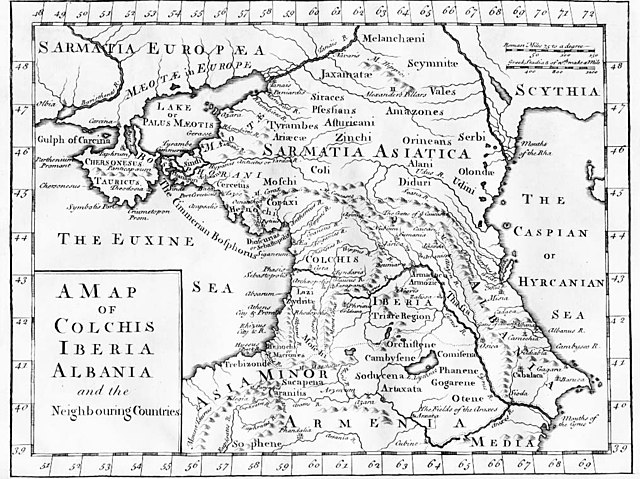
English: "A Map of Colchis, Iberia, Albania, and the neighbouring countries". A map of the Caucasus / Crimea (Chersonesus Tauricus)/ southern Russia region during classical antiquity (the ancient period). Note that the "Albania" referred to was on the Caspian Sea (not the modern Albania in the Balkans). Copper-engraved map, no publisher or date, London, ca 1770 (or 1729?).
Deutsch: Kaukasus mit Siedlungsgebieten von Sarmaten und Amazonen in der Antike, Kupferstich von ca. 1770
Français : La Colchide, l’Ibérie (orientale), l’Albanie (orientale) et les régions voisines
ქართული: ანტიკური ხანის კოლხეთი, ბერძნულ წყაროებზე დაყრდნობით, დაბეჭდილია ლონდონში, 1770.
Nederlands: Kaart van de Kaukasus, ca. 1770
Русский: «Европейская Сарматия». Карта основана на греческих литературных источниках, напечатана в Лондоне в 1770 |
| 日付 | 1770年頃 |
| 原典 |
|
| 作者 | last upload en:User:AnonMoos |
ライセンス
|
このファイルは、パブリックドメインの状態にある平面的な美術の著作物を写真術によって忠実に複製したものです。このような複製はアメリカ合衆国においてパブリックドメインの状態にあります。その他の地域では再利用に制限がかかる場合があります。詳しくはReuse of PD-Art photographsをご覧ください。美術の著作物としての原図は、次の理由によりパブリックドメインの状態にあります。
| ||||
元のアップロードログ
File upload history on en:
- 20:53, 27 October 2005 . . AnonMoos (Talk) . . 1016x760 (198173 bytes) (Version of image losslessly cropped to region of interest with Jpegcrop program. )
- 20:32, 3 July 2005 . . PANONIAN (Talk) . . 1254x760 (224060 bytes) (historic map )
| date/time | username | resolution | size | edit summary | |
|---|---|---|---|---|---|
| 14:53, 29 December 2005 | User:Ustas | <a href="http://upload.wikimedia.org/wikipedia/commons/d/df/1729.jpg"><img alt="Thumbnail for version as of 14:53, 29 December 2005" src="http://upload.wikimedia.org/wikipedia/commons/thumb/d/df/1729.jpg/120px-1729.jpg" width="120" height="90" border="0" /></a> | 1,016×760 | 194 KB | {{Information |Description = Copper-engraved map, no publisher or date, London, ca 1770. |Source = <a href="http://en.wikipedia.org/wiki/Image:1729.jpg" class="extiw" title="en:Image:1729.jpg">en:Image:1729.jpg</a>, [http://www.village-atlas.com/ancient/ancient.html] |Date = |Author = last upload <a href="http://en.wikipedia.org/wiki/User:AnonMoos" class="extiw" title="en:User:AnonMoos">en:User:AnonMoos</a> |Permission = PD |other_ver |
ファイルの履歴
過去の版のファイルを表示するには、その版の日時をクリックしてください。
| 日付と時刻 | サムネイル | 寸法 | 利用者 | コメント | |
|---|---|---|---|---|---|
| 現在の版 | 2008年10月22日 (水) 16:02 | | 1,016 × 760 (194キロバイト) | BetacommandBot | move approved by: User:Deadstar This image was moved from Image:1729.jpg {{Information |Description = "A Map of Colchis, Iberia, Albania, and the neighbouring countries". A map of the Caucasus / Crimea / southern Russia region during classical |
ファイルの使用状況
以下のページがこのファイルを使用しています:
グローバルなファイル使用状況
以下に挙げる他のウィキがこの画像を使っています:
- als.wikipedia.org での使用状況
- an.wikipedia.org での使用状況
- ar.wikipedia.org での使用状況
- az.wikipedia.org での使用状況
- ba.wikipedia.org での使用状況
- bn.wikipedia.org での使用状況
- ca.wikipedia.org での使用状況
- co.wikipedia.org での使用状況
- cy.wikipedia.org での使用状況
- da.wikipedia.org での使用状況
- de.wikipedia.org での使用状況
- el.wikipedia.org での使用状況
- en.wikipedia.org での使用状況
- es.wikipedia.org での使用状況
- eu.wikipedia.org での使用状況
- fa.wikipedia.org での使用状況
- fi.wikipedia.org での使用状況
- fr.wikipedia.org での使用状況
- fy.wikipedia.org での使用状況
- gl.wikipedia.org での使用状況
- he.wikipedia.org での使用状況
- hr.wikipedia.org での使用状況
- hu.wikipedia.org での使用状況
- hyw.wikipedia.org での使用状況
- it.wikipedia.org での使用状況
このファイルのグローバル使用状況を表示する。