
ファイル:Map indicating Baffin Bay.png
高解像度版はありません。
Map_indicating_Baffin_Bay.png (425 × 365 ピクセル、ファイルサイズ: 68キロバイト、MIME タイプ: image/png)
ウィキメディア・コモンズのファイルページにある説明を、以下に表示します。
|
概要
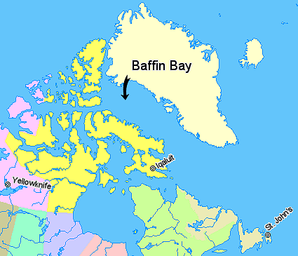
Map indicating Baffin Bay, lying between Greenland and Nunavut, Canada.
Nunavut
Quebec
Newfoundland and Labrador
Northwest Territories
Regions outside Canada (Greenland, Iceland)
© Her Majesty the Queen in Right of Canada, Department of Natural Resources. All rights reserved.
Licence Agreement
ライセンス

|
このファイルの著作者は、著作者の帰属を適切に表示することを条件に、あらゆる目的でこのファイルを使用することを許可しています。再頒布、二次的著作物の制作、商用利用、その他あらゆる利用が許可されています。 |
|
|
ファイルの履歴
過去の版のファイルを表示するには、その版の日時をクリックしてください。
| 日付と時刻 | サムネイル | 寸法 | 利用者 | コメント | |
|---|---|---|---|---|---|
| 現在の版 | 2006年3月21日 (火) 03:40 | | 425 × 365 (68キロバイト) | David Kernow~commonswiki | Map indicating Baffin Bay, lying between Greenland and Nunavut, Canada. {{legend|#ffff66|Nunavut}} {{legend|#d5fe94|Quebec}} {{legend|#ecebb6|Newfoundland and Labrador {{legend|#ffccff|Northwest Territories}} {{legend|#ffffcc|Regions out |
ファイルの使用状況
以下の 2 ページがこのファイルを使用しています:
グローバルなファイル使用状況
以下に挙げる他のウィキがこの画像を使っています:
- ar.wikipedia.org での使用状況
- az.wikipedia.org での使用状況
- ban.wikipedia.org での使用状況
- ba.wikipedia.org での使用状況
- bg.wikipedia.org での使用状況
- ce.wikipedia.org での使用状況
- cs.wikipedia.org での使用状況
- cv.wikipedia.org での使用状況
- da.wikipedia.org での使用状況
- de.wiktionary.org での使用状況
- fi.wikipedia.org での使用状況
- fr.wikipedia.org での使用状況
- gl.wikipedia.org での使用状況
- he.wikipedia.org での使用状況
- id.wikipedia.org での使用状況
- it.wikipedia.org での使用状況
- ku.wikipedia.org での使用状況
- lt.wikipedia.org での使用状況
- mn.wikipedia.org での使用状況
- no.wikipedia.org での使用状況
- sh.wikipedia.org での使用状況
- sk.wikipedia.org での使用状況
- vi.wikipedia.org での使用状況
- xmf.wikipedia.org での使用状況