
ファイル:Location greek ancient.png
高解像度版はありません。
Location_greek_ancient.png (248 × 113 ピクセル、ファイルサイズ: 4キロバイト、MIME タイプ: image/png)
ウィキメディア・コモンズのファイルページにある説明を、以下に表示します。
|
概要
| 解説 |
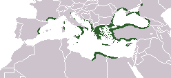
English: Locator map depicting the ancient Greek world, c. 550 BC |
|||
| 日付 | ||||
| 原典 | Self-created, after http://www.wwnorton.com/nrl/english/nawol/maps/MAP7GRCO.JPG | |||
| 作者 | User:ChrisO | |||
| 許可 (ファイルの再利用) |
|
|||
| その他のバージョン |
|


ファイルの履歴
過去の版のファイルを表示するには、その版の日時をクリックしてください。
| 日付と時刻 | サムネイル | 寸法 | 利用者 | コメント | |
|---|---|---|---|---|---|
| 現在の版 | 2021年9月27日 (月) 16:20 | | 248 × 113 (4キロバイト) | Deji Olajide1999 | Added the missing regions of Orestis, Elimiotis, Eordaia and Tymphaea + cleared up the Greek colonies in Thrace. |
| 2018年1月23日 (火) 09:22 |  | 248 × 113 (4キロバイト) | Maphobbyist | Added Colchis. | |
| 2014年6月26日 (木) 16:15 |  | 248 × 113 (6キロバイト) | SilentResident | Added missing kingdom of Epirus | |
| 2012年12月29日 (土) 10:55 |  | 248 × 113 (5キロバイト) | Gepgepgep | Aggiunta l'area di colonizzazione greca dell'Adriatico, che mancava completamente | |
| 2011年9月5日 (月) 17:22 |  | 248 × 113 (5キロバイト) | Spesh531 | Showing borders that are recognized. Still showing unrecognized countries for a reference of where Ancient Greek was. It was also about the shape of the lands, as Greek Islands where either not shown correctly or not there at all | |
| 2011年9月5日 (月) 13:00 |  | 248 × 113 (4キロバイト) | Maphobbyist | Pfrevious user Saguamundi is right. International borders, and NOT disputed borders must be shown. Nor is this about the present but about historical Greek settlements. There is no place for current politics for a historical map. | |
| 2011年9月4日 (日) 22:28 |  | 248 × 113 (5キロバイト) | Spesh531 | Reverted to version as of 01:56, 11 May 2011 The border were fine, your showing territories where some are unrecognizable | |
| 2011年9月4日 (日) 22:21 |  | 248 × 113 (5キロバイト) | Spesh531 | Reverted to version as of 01:56, 11 May 2011 The border were fine, your showing territories where some are unrecognizable | |
| 2011年9月4日 (日) 21:26 |  | 248 × 113 (4キロバイト) | Saguamundi | Same map but with internationally recognized borders. | |
| 2011年5月11日 (水) 01:56 |  | 248 × 113 (5キロバイト) | Spesh531 | update more to source, the current Greece was not under territory. |
ファイルの使用状況
このファイルを使用しているページはありません。
グローバルなファイル使用状況
以下に挙げる他のウィキがこの画像を使っています:
- en.wikipedia.org での使用状況
- pl.wikibooks.org での使用状況