
ファイル:Kamianets-Podilskyi map 1691.jpg

元のファイル (2,296 × 1,680 ピクセル、ファイルサイズ: 1.58メガバイト、MIME タイプ: image/jpeg)
ウィキメディア・コモンズのファイルページにある説明を、以下に表示します。
|
概要
| 記述 |
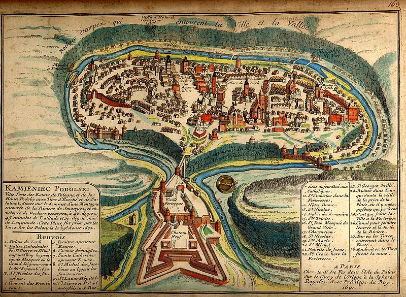
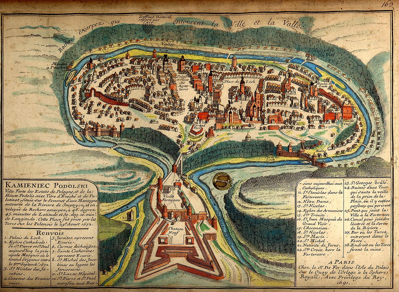
Українська: Давня французька мапа Кам'янця-Подільського 1691 після його захоплення турками
Русский: Старинная карта Каменца-Подольского 1691 года. |
|||||||||||||||||||||||
| Map legend |
Français : KAMIENIEC PODOLSKI Ville forte des Estats de Pologne, et de la Haute Podolie avec Titre d'Evéché et de Palatinat, située sur le Sommet d’une Montagne entourée de la Riviere de Smotrycz, et envelopée de Rochers escarpez, à 48. degrez 45. minutes de Latitude et 50. deg. 10. min. de Longitude. Cette Place fut prise par les Turcs sur Polonais le 29e Aoust 1672. Renvois
A PARIS |
|||||||||||||||||||||||
| 日付 | ||||||||||||||||||||||||
| 原典 | brooks-planck.org | |||||||||||||||||||||||
| 作者 |
|
|||||||||||||||||||||||
| Georeferencing | If inappropriate please set warp_status = skip to hide. | |||||||||||||||||||||||

Fortified city of the Polish State and of Upper Podolia, with the title of bishopric and palatinate [voivodeship], situated on top of a mountain surrounded by the Smotrycz River and enclosed by steep rocks, at 48°45’ latitude and 50°10’ longitude. This place was taken by the Turks from the Poles on 29 August 1672.
References
- Lech’s Palace
- Cathedral church of St Peter and St Paul, today the main mosque where the Grand Vizier entered on 3 September 1672
- St Nicholas’ [church] of the Dominicans
- Franciscan monastery
- Jesuits’ [church], now a stable
- Discalced Carmelites’ [church]
- St Catherine’s [church], now a stable
- Jesuits’ [church] of St Michael where the janissaries are quartered
- St Lazarus Hospital
- St Peter’s and St Paul’s [church], previously Ruthenian [Orthodox], today Catholic
- St Stanislaus’ [church] in the fortress
- Our Lady’s [church]
- St Nicholas’ [church]
- Armenian [Orthodox] church
- Holy Trinity [church]
- St John’s [church, now] Grand Vizier’s mosque
- Ascension [church]
- St Nicholas’ [church]
- St Mary’s [church]
- St Michael’s [church]
- Nativity [church]
- Holy Cross [church] outside the fortress
- St George’s [church], burnt
- Ruins of a tower which collapsed on the eve of the city’s capture, where 600 people perished
- Bridge linking the city with the fortress
- Canal linking the inlet and the outlet of the river
- [Place] where the Turks entered the moat
- Place where the Turks planted a mine
[Made] in Paris
At Mr. [Nicolas] De Fer’s [workshop] on the Palace Island on the Clock Quay at the Royal Sphere. With royal privilege, 1691.
Full text of the legend
| 注釈 | この画像には注釈がついています: コモンズで注釈を見る |
ライセンス
|
この著作物は、著作権の保護期間が著作者の死後100年以下である国・地域においてパブリックドメインの状態にあります。 | |
| このファイルは著作権法の既知の制約(隣接権や関連する権利を含む)から自由であると特定されています。 | |
評価
|

ファイルの履歴
過去の版のファイルを表示するには、その版の日時をクリックしてください。
| 日付と時刻 | サムネイル | 寸法 | 利用者 | コメント | |
|---|---|---|---|---|---|
| 現在の版 | 2007年10月18日 (木) 23:29 | | 2,296 × 1,680 (1.58メガバイト) | DDima | {{Information |Description={{en|An 1691 map of the Ukrainian City of Kamianets-Podilskyi.}} {{ru|Старинная карта Каменца-Подольского 1691 года}} |Source=[[:ru:Изображени |
ファイルの使用状況
以下の 5 ページがこのファイルを使用しています:
グローバルなファイル使用状況
以下に挙げる他のウィキがこの画像を使っています:
- ast.wikipedia.org での使用状況
- az.wikipedia.org での使用状況
- be.wikipedia.org での使用状況
- bg.wikipedia.org での使用状況
- ca.wikipedia.org での使用状況
- de.wikipedia.org での使用状況
- dsb.wikipedia.org での使用状況
- el.wikipedia.org での使用状況
- en.wikipedia.org での使用状況
- Wikipedia:WikiProject Former countries
- Podolian Voivodeship
- Kamianets-Podilskyi
- Portal:Ukraine
- Portal:Ukraine/Featured picture
- Portal talk:Ukraine/Featured picture
- Wikipedia:WikiProject Poland
- User:Sashazlv/Try
- Portal:History/Featured picture
- Wikipedia:WikiProject Urban studies and planning
- Portal:Maps/Selected picture
- Wikipedia:Featured pictures thumbs/08
- Wikipedia:WikiProject Ukraine
- User talk:DDima/Archive 3
- Wikipedia:Featured picture candidates/Kamianets-Podilskyi map
- Wikipedia:Wikipedia Signpost/2007-11-05/Features and admins
- Wikipedia:Featured picture candidates/November-2007
- Portal:Maps/Selected picture/30
- Wikipedia:Picture of the day/March 2008
- Kamianets-Podilskyi Castle
- Template:POTD/2008-03-09
- Wikipedia:Featured pictures/Diagrams, drawings, and maps/Maps
- Portal:Russia/Selected picture/11
- Wikipedia:Wikipedia Signpost/2007-11-05/SPV
- Podolia Eyalet
- Royal city in Polish–Lithuanian Commonwealth
- Portal:Poland/Recognized content
- Portal:Ukraine/Recognized content
- Wikipedia:WikiProject Former countries/Recognized content
- Wikipedia:Wikipedia Signpost/Single/2007-11-05
- en.wikivoyage.org での使用状況
- es.wikipedia.org での使用状況
- fr.wikipedia.org での使用状況
このファイルのグローバル使用状況を表示する。