
ファイル:Jacarepaguá.svg

この SVG ファイルのこの PNG プレビューのサイズ: 800 × 424 ピクセル. その他の解像度: 320 × 170 ピクセル | 640 × 340 ピクセル | 1,024 × 543 ピクセル | 1,280 × 679 ピクセル | 2,560 × 1,358 ピクセル | 1,376 × 730 ピクセル。
元のファイル (SVG ファイル、1,376 × 730 ピクセル、ファイルサイズ: 41キロバイト)
ウィキメディア・コモンズのファイルページにある説明を、以下に表示します。
|
概要
| 解説 |
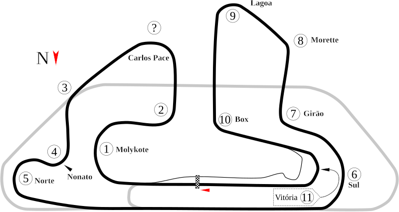
English: Jacarepaguá AKA Autódromo Internacional Nelson Piquet. Note: The old image below shouldn't be deleted as it appears to show a different version of the course. This image shows what was visible in Google Earth as of the creation date. Also, the question mark denotes a turn that wasn't in the old image. Because there was no website for the track (the Wikipedia article lists it as be torn out), the only numbered turns are those in the old image. |
| 日付 | |
| 原典 | 投稿者自身による著作物 |
| 作者 | Will Pittenger |
| その他のバージョン |
|

| カメラの位置 | | 以下のサービスでこの位置を確認する: オープンストリートマップ |
|---|
ライセンス
| この著作物の著作権者である私は、この著作物における権利を放棄しパブリックドメインとします。これは全世界で適用されます。 一部の国では、これが法的に可能ではない場合があります。その場合は、次のように宣言します。 私は、あらゆる人に対して、法により必要とされている条件を除き、如何なる条件も課すことなく、あらゆる目的のためにこの著作物を使用する権利を与えます。 |
ファイルの履歴
過去の版のファイルを表示するには、その版の日時をクリックしてください。
| 日付と時刻 | サムネイル | 寸法 | 利用者 | コメント | |
|---|---|---|---|---|---|
| 現在の版 | 2008年7月17日 (木) 23:05 | | 1,376 × 730 (41キロバイト) | Will Pittenger | New version adds north indicator that I forgot to add. |
| 2008年7月17日 (木) 06:22 |  | 1,376 × 730 (40キロバイト) | Will Pittenger | {{Information |Description={{en|1=[[]]w:Autódromo Internacional Nelson Piquet.}} |Source=Own work by uploader |Author=Will Pittenger |Date=7-17-2008 |Permission= |other_versions=<gallery>Image:Circuit Jacarepagua.png|Old PNG |
ファイルの使用状況
以下の 5 ページがこのファイルを使用しています:
グローバルなファイル使用状況
以下に挙げる他のウィキがこの画像を使っています:
- af.wikipedia.org での使用状況
- ar.wikipedia.org での使用状況
- حلبة نيلسون بيكيه الدولية
- جائزة ريو دي جانيرو الكبرى للدراجات النارية 1995
- جائزة ريو دي جانيرو الكبرى للدراجات النارية 1996
- جائزة ريو دي جانيرو الكبرى للدراجات النارية 1997
- جائزة ريو دي جانيرو الكبرى للدراجات النارية 1999
- جائزة ريو دي جانيرو الكبرى للدراجات النارية 2000
- جائزة ريو دي جانيرو الكبرى للدراجات النارية 2001
- جائزة ريو دي جانيرو الكبرى للدراجات النارية 2002
- جائزة ريو دي جانيرو الكبرى للدراجات النارية 2003
- جائزة ريو دي جانيرو الكبرى للدراجات النارية 2004
- ast.wikipedia.org での使用状況
- bg.wikipedia.org での使用状況
- bn.wikipedia.org での使用状況
- bs.wikipedia.org での使用状況
- ca.wikipedia.org での使用状況
- de.wikipedia.org での使用状況
- en.wikipedia.org での使用状況
- Autódromo Internacional Nelson Piquet
- Rio de Janeiro motorcycle Grand Prix
- User talk:Chubbennaitor/archive2
- User talk:Barkjon/Archive 2
- 2002 Rio de Janeiro motorcycle Grand Prix
- 2003 Rio de Janeiro motorcycle Grand Prix
- 2004 Rio de Janeiro motorcycle Grand Prix
- 1995 Rio de Janeiro motorcycle Grand Prix
- 1996 Rio de Janeiro motorcycle Grand Prix
- Wikipedia:WikiProject Formula One/Newsletter/200808
- User talk:Hellboy2hell/archive2
- User talk:NapHit/Archive 1
- User talk:4u1e/archive5
- List of Grand Prix motorcycle circuits
- User talk:Typ932/Archive 3
- User talk:Midgrid/Archive 6
- 1997 Rio de Janeiro motorcycle Grand Prix
- 1999 Rio de Janeiro motorcycle Grand Prix
- 2000 Rio de Janeiro motorcycle Grand Prix
- User talk:Thelb4/Archive 5
- User talk:Chubbennaitor/Archive7
- User talk:Readro/Archive 3
- User talk:Donnie Park/Archive 1
- User talk:The359/Archive 4
- 2001 Rio de Janeiro motorcycle Grand Prix
- User talk:Cs-wolves/Archive 3
- User talk:Bam123456789/Archive 1
- User talk:Sage Callahan/Archive 1
- User talk:Cdhaptomos/Archive 1
- User talk:Spenalzo/Archive/2008
このファイルのグローバル使用状況を表示する。