
ファイル:India Bangladesh border US Army Map Service.jpg

このプレビューのサイズ: 517 × 599 ピクセル。 その他の解像度: 207 × 240 ピクセル | 414 × 480 ピクセル | 680 × 788 ピクセル。
元のファイル (680 × 788 ピクセル、ファイルサイズ: 288キロバイト、MIME タイプ: image/jpeg)
ウィキメディア・コモンズのファイルページにある説明を、以下に表示します。
|
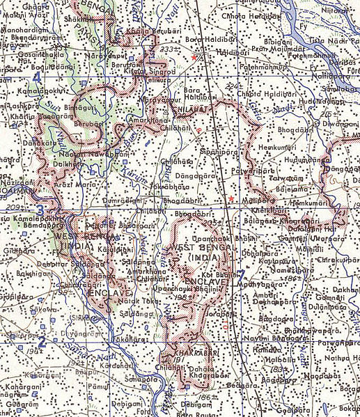
Map of part of the India-north Bangladesh border, US army map service, 1960s. Shows a couple of the larger exclaves of India, but is simplified due to the tiny size of many of them. Located in area near 26°15′43″N 88°45′6″E / 26.26194°N 88.75167°E There were at least 129 smaller enclaves and second-level enclaves on both sides of this border, see external link for a more detailed map. Note: Bangladesh is shown as 'East Pakistan'.
このファイルは、アメリカ合衆国の連邦政府と雇用関係にある公務員がその職務上作成したアメリカ合衆国政府の著作物であり、アメリカ合衆国の著作権法上パブリックドメインに属します (17 U.S.C. §105)。
注意:このライセンスは、アメリカ合衆国政府の著作物についてのみ効力を有します。アメリカ合衆国の各州、郡、その他の地方自治体が作成した著作物に対しては適用できません。
|
 | |
| このファイルは著作権法の既知の制約(隣接権や関連する権利を含む)から自由であると特定されています。 | ||
[üCategory:International borders of India]]
ファイルの履歴
過去の版のファイルを表示するには、その版の日時をクリックしてください。
| 日付と時刻 | サムネイル | 寸法 | 利用者 | コメント | |
|---|---|---|---|---|---|
| 現在の版 | 2007年5月14日 (月) 10:31 | | 680 × 788 (288キロバイト) | Roke~commonswiki | Map of the India-Bangladesh border, US army map service, 1960s. Shows some of the enclaves on the border, but is simplified. {{PD-PCL|txu-oclc-6614190-ng45-8.jpg|/ams/india/}} Category:Maps of India Category:Maps of Bangladesh |
ファイルの使用状況
以下のページがこのファイルを使用しています:
グローバルなファイル使用状況
以下に挙げる他のウィキがこの画像を使っています:
- bn.wikipedia.org での使用状況
- de.wikipedia.org での使用状況
- en.wikipedia.org での使用状況
- es.wikipedia.org での使用状況
- fr.wikipedia.org での使用状況
- mt.wikipedia.org での使用状況
- nl.wikipedia.org での使用状況
- pt.wikipedia.org での使用状況