
ファイル:Historical Map of Sikkim in northeastern India.jpg

このプレビューのサイズ: 691 × 600 ピクセル。 その他の解像度: 276 × 240 ピクセル | 553 × 480 ピクセル | 885 × 768 ピクセル | 1,179 × 1,024 ピクセル | 2,359 × 2,048 ピクセル | 4,510 × 3,916 ピクセル。
元のファイル (4,510 × 3,916 ピクセル、ファイルサイズ: 14.76メガバイト、MIME タイプ: image/jpeg)
ウィキメディア・コモンズのファイルページにある説明を、以下に表示します。
|
概要
ライセンス
このファイルはアメリカ合衆国においてパブリックドメインの状態にあります。これは多くの場合、最初の公表が1929年1月1日以前であるために著作権が消滅したアメリカ合衆国の著作物に適用されます。より詳細な説明については、このページをご覧ください。
|
 | |
 |
このファイルはアメリカ合衆国以外ではパブリックドメインの状態にはない可能性があり、この点は、特に、カナダ、中華人民共和国(香港・マカオを除く)、ドイツ、メキシコ及びスイスのようにアメリカ合衆国の著作物の著作権の保護期間について相互主義を採用していない国・地域で当てはまります。作者や公表年は必要な情報であり、条件とされるべきものです。詳細についてはWikipedia:Public domain及びWikipedia:Copyrightsをご覧ください。
|
|
このファイルは、パブリックドメインの状態にある平面的な美術の著作物を写真術によって忠実に複製したものです。このような複製はアメリカ合衆国においてパブリックドメインの状態にあります。その他の地域では再利用に制限がかかる場合があります。詳しくはReuse of PD-Art photographsをご覧ください。美術の著作物としての原図は、次の理由によりパブリックドメインの状態にあります。
| ||||
元のアップロードログ
元のファイルページはこちら。以下の利用者は全てen.wikipediaに属します。
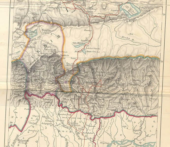
- 2009-10-14 10:25 Hindutashravi 4510×3916× (15480075 bytes) Historical Map of Sikkim in northeastern India extracted from map prepared by Trelawney Saunders, 1876 titled The routes of Bogle, Turner and Manning between Bengal and Tibet, and published in the book Titled, Narratives of the Mission of George Bogle
ファイルの履歴
過去の版のファイルを表示するには、その版の日時をクリックしてください。
| 日付と時刻 | サムネイル | 寸法 | 利用者 | コメント | |
|---|---|---|---|---|---|
| 現在の版 | 2010年6月25日 (金) 07:38 | | 4,510 × 3,916 (14.76メガバイト) | File Upload Bot (Magnus Manske) | {{BotMoveToCommons|en.wikipedia|year={{subst:CURRENTYEAR}}|month={{subst:CURRENTMONTHNAME}}|day={{subst:CURRENTDAY}}}} {{Information |Description={{en|Historical Map of Sikkim in northeastern India extracted from map prepared by Trelawney Saunders, 1876 |
ファイルの使用状況
以下のページがこのファイルを使用しています:
グローバルなファイル使用状況
以下に挙げる他のウィキがこの画像を使っています:
- as.wikipedia.org での使用状況
- bn.wikipedia.org での使用状況
- en.wikipedia.org での使用状況
- gu.wikipedia.org での使用状況
- he.wikipedia.org での使用状況
- hi.wikipedia.org での使用状況
- id.wikipedia.org での使用状況
- kn.wikipedia.org での使用状況
- my.wikipedia.org での使用状況
- nl.wikipedia.org での使用状況
- pt.wikipedia.org での使用状況
- sa.wikipedia.org での使用状況
- si.wikipedia.org での使用状況
- ta.wikipedia.org での使用状況
- th.wikipedia.org での使用状況
- vi.wikipedia.org での使用状況