
ファイル:Greater austria.png

このプレビューのサイズ: 703 × 600 ピクセル。 その他の解像度: 281 × 240 ピクセル | 563 × 480 ピクセル | 900 × 768 ピクセル | 1,200 × 1,024 ピクセル | 1,500 × 1,280 ピクセル。
元のファイル (1,500 × 1,280 ピクセル、ファイルサイズ: 45キロバイト、MIME タイプ: image/png)
ウィキメディア・コモンズのファイルページにある説明を、以下に表示します。
|
概要
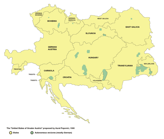
- English: map of the proposed United States of Greater Austria in 1906
- Serbian: мапа предложених Сједињених Држава Велике Аустрије (1906. године)
Source and licence

|
This map has been uploaded by Electionworld from en.wikipedia.org to enable the |
| この著作物は、著作者であるPANONIANによって権利が放棄され、パブリックドメインとされました。これは全世界で適用されます。 一部の国では、これが法的に可能ではない場合があります。その場合は、次のように宣言します。 |
self made map by user:PANONIAN
see de:Bild:Vereinigte Staaten von Groß-Österreich.png for german version. --Rdb 12:12, 2 April 2007 (UTC)
ファイルの履歴
過去の版のファイルを表示するには、その版の日時をクリックしてください。
| 日付と時刻 | サムネイル | 寸法 | 利用者 | コメント | |
|---|---|---|---|---|---|
| 現在の版 | 2006年12月23日 (土) 22:47 | | 1,500 × 1,280 (45キロバイト) | Electionworld | {{ew|en|PANONIAN}} {{PD-user|PANONIAN}} map of the {{link|United States of Greater Austria}} (self made) |
ファイルの使用状況
以下のページがこのファイルを使用しています:
グローバルなファイル使用状況
以下に挙げる他のウィキがこの画像を使っています:
- be.wikipedia.org での使用状況
- cy.wikipedia.org での使用状況
- el.wikipedia.org での使用状況
- en.wikipedia.org での使用状況
- eu.wikipedia.org での使用状況
- fi.wikipedia.org での使用状況
- fr.wikipedia.org での使用状況
- hu.wikipedia.org での使用状況
- id.wikipedia.org での使用状況
- it.wikipedia.org での使用状況
- ko.wikipedia.org での使用状況
- lmo.wikipedia.org での使用状況
- pt.wikipedia.org での使用状況
- ro.wikipedia.org での使用状況
- ru.wikipedia.org での使用状況
- sk.wikipedia.org での使用状況
- uk.wikipedia.org での使用状況
- vi.wikipedia.org での使用状況
- zh.wikipedia.org での使用状況