
ファイル:FuehrerBunkerBerlinLocation.jpg
元のファイル (700 × 830 ピクセル、ファイルサイズ: 532キロバイト、MIME タイプ: image/jpeg)
ウィキメディア・コモンズのファイルページにある説明を、以下に表示します。
|
| 解説 |
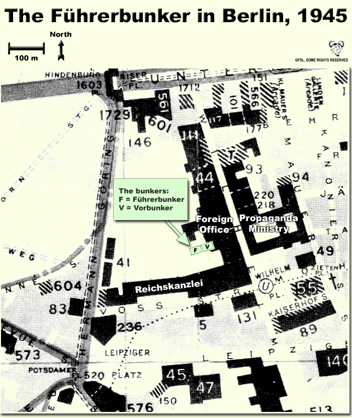
Map showing the locations of the Fuehrerbunker and Vorbunker in Berlin, 1945. |
| 日付 | |
| 原典 | 投稿者自身による著作物 |
| 作者 | User:Dna-Dennis |
| 許可 (ファイルの再利用) |
CC, see below. The map is completely unrestricted for any Wikipedia/Wikimedia project. |
ライセンス
- あなたは以下の条件に従う場合に限り、自由に
- 共有 – 本作品を複製、頒布、展示、実演できます。
- 再構成 – 二次的著作物を作成できます。
- あなたの従うべき条件は以下の通りです。
- 表示 – あなたは適切なクレジットを表示し、ライセンスへのリンクを提供し、変更があったらその旨を示さなければなりません。これらは合理的であればどのような方法で行っても構いませんが、許諾者があなたやあなたの利用行為を支持していると示唆するような方法は除きます。
概要
This is a map showing the locations of the Fuehrerbunker and Vorbunker in Berlin, 1945. These locations are not necessarily perfectly exact, but they are very probable. There were two bunkers which were connected - the Fuehrerbunker and the Vorbunker, and here are the links to my maps of these bunkers:
Information about the details of the bunkers is rather scarce, which is not strange, since the bunkers were secret. This map is based on the excellent research of Tom Posch (see below), who visited and photographed the remains from inside in 1988. He concluded that the map of the bunker in Cornelius Ryan's The Last Battle was incorrect, and a new, hand-drawn map of the Vorbunker was produced by Tom Posch.
Notes on the location of the bunkers
The Fuehrerbunker, built in 1943/44, was located 8-17 meters beneath the Reichskanzlei garden, approx. 120 meters north of the new Reichskanzlei building, which had the address Vossstrasse 6. The Führerbunker was located somewhat lower than the Vorbunker and west (or rather west-west-south) of it. The two bunkers were connected via sets of stairs set at right angles (not spiral).
Construction data (approximates)
- Material: Concrete
- Protective Wall Width: 220 cm
- Protective Roof Height: 280 cm
- Wall Width (interior): 15-20 cm
- Door Heights: 180-200 cm
- Door Widths: 120 cm
- Room Heights: 2-3 m
- Room Sizes: Varying; 3-5 m
References
The map is based on the following sources:
- Ramsey, Winston G. (editor) & Posch, Tom (researcher), The Berlin Führerbunker: The Thirteenth Hole, After the Battle アーカイブされたコピー at the Wayback Machine, No.61, Special Edition, Battle of Britain International Ltd, 1988, London
- Allied Intelligence Map of Key Buildings in Berlin (3rd edition, 1945)
- Ryan, Cornelius, The Last Battle (1966)
Regards,
Dennis Nilsson, Sweden.
If you wish to contact me, please leave a message on my talk page.
ファイルの履歴
過去の版のファイルを表示するには、その版の日時をクリックしてください。
| 日付と時刻 | サムネイル | 寸法 | 利用者 | コメント | |
|---|---|---|---|---|---|
| 現在の版 | 2007年10月12日 (金) 02:37 | | 700 × 830 (532キロバイト) | Dna-webmaster~commonswiki | minor fix |
| 2007年10月12日 (金) 02:06 |  | 700 × 830 (530キロバイト) | Dna-webmaster~commonswiki | Uploaded new version | |
| 2005年12月14日 (水) 00:19 |  | 720 × 946 (442キロバイト) | Dna-webmaster~commonswiki | ||
| 2005年11月14日 (月) 08:30 |  | 720 × 946 (453キロバイト) | Dna-webmaster~commonswiki |
ファイルの使用状況
以下のページがこのファイルを使用しています:
グローバルなファイル使用状況
以下に挙げる他のウィキがこの画像を使っています:
- ar.wikipedia.org での使用状況
- ast.wikipedia.org での使用状況
- br.wikipedia.org での使用状況
- el.wikipedia.org での使用状況
- en.wikipedia.org での使用状況
- es.wikipedia.org での使用状況
- fi.wikipedia.org での使用状況
- fr.wikipedia.org での使用状況
- hu.wikipedia.org での使用状況
- ru.wikipedia.org での使用状況