
ファイル:Florida-Pensacola-map-legend-X-6-1756-FAA.gif
高解像度版はありません。
Florida-Pensacola-map-legend-X-6-1756-FAA.gif (475 × 400 ピクセル、ファイルサイズ: 16キロバイト、MIME タイプ: image/gif)
ウィキメディア・コモンズのファイルページにある説明を、以下に表示します。
|
概要
| 解説 |
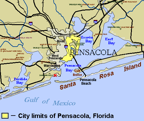
English: City map of Pensacola, with city limits marked by legend (see References maps). The site of the first settlement near Pensacola (Ochuse) is marked by the red "X" near the site of Fort Barrancas. Small crosses designate airfields in the region. Areas have been labeled for the communities of Brent, West Pensacola, Warrington, Gulf Breeze, and Pensacola Beach. (Several other towns have not been labeled.) |
| 原典 |
(Original text: Source URL (U.S. Government FAA): http://tfr.faa.gov/save_maps/map_6_1756.gif (Airfield map trimmed/edited to set Pensacola city limits, label "Santa Rosa Island" (below site marked "X") plus Interstate-10/110 icons, "Pensacola Bay" and other bays). The file is in GIF format, which can be edited in detail without loss of colors. References
|
| 作者 |
ライセンス
This image or file is a work of a Federal Aviation Administration employee, taken or made as part of that person's official duties. As a work of the U.S. federal government, the image is in the public domain in the United States.
|
 |
元のアップロードログ
元のファイルページはこちら。以下の利用者は全てen.wikipediaに属します。
| 日付と時刻 | 寸法 | 利用者 | コメント |
|---|---|---|---|
| 2007-07-31 16:42 | 475×400× (16590 bytes) | Wikid77 | Map width cropped 21% to enlarge labels 21%. Added "Pensacola Beach" & enlarged "Warrington" with I-10 icons. |
| 2007-07-29 13:41 | 600×455× (19615 bytes) | Wikid77 | Reduced Pensacola city limits (see reference maps), icons I-10/110, labeled [[Brent, FL|Brent]], [[Warrington, FL|Warrington]], "[[West Pensacola, FL|West Pensacola]]" & Gulf Breeze. |
| 2007-01-12 04:25 | 600×455× (18935 bytes) | Wikid77 | City map of [[Pensacola, Florida]], with city limits marked by legend. The site of the [[History of Pensacola, Florida|first settlement]] of Pensacola (''Ochuse'') is marked by the red "X" at the site of [[Fort Barrancas]]. Small crosses designate airfie |
| 2007-01-11 20:23 | 600×470× (18863 bytes) | Wikid77 | City map of [[Pensacola, Florida]], with city limits marked by legend. The site of the [[History of Pensacola, Florida|first settlement]] of Pensacola (''Ochuse'') is marked by the red "X" at the site of [[Fort Barrancas]]. Small crosses designate airfie |
ファイルの履歴
過去の版のファイルを表示するには、その版の日時をクリックしてください。
| 日付と時刻 | サムネイル | 寸法 | 利用者 | コメント | |
|---|---|---|---|---|---|
| 現在の版 | 2014年10月6日 (月) 08:48 | | 475 × 400 (16キロバイト) | Urdangaray | Transferred from en.wikipedia |
ファイルの使用状況
以下のページがこのファイルを使用しています:
グローバルなファイル使用状況
以下に挙げる他のウィキがこの画像を使っています:
- en.wikipedia.org での使用状況
- es.wikipedia.org での使用状況