
ファイル:Europe, 1714.png
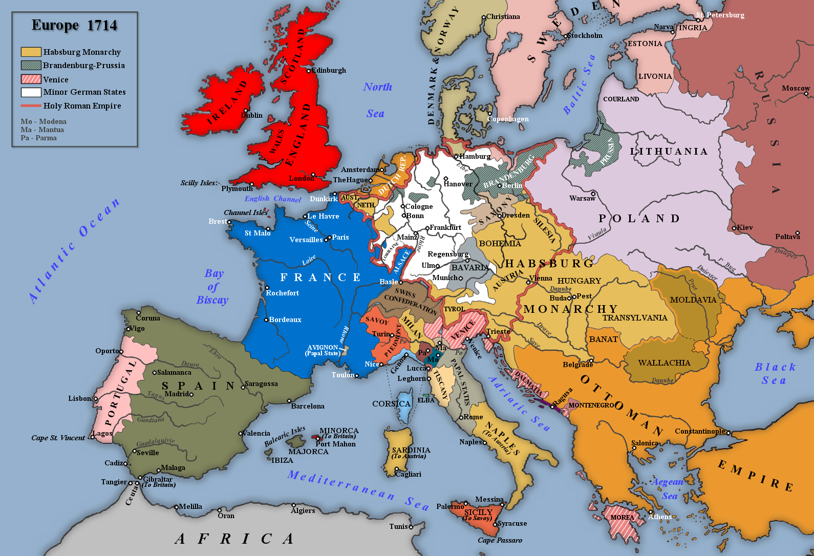
このプレビューのサイズ: 800 × 546 ピクセル。 その他の解像度: 320 × 219 ピクセル | 640 × 437 ピクセル | 1,024 × 699 ピクセル | 1,280 × 874 ピクセル | 1,590 × 1,086 ピクセル。
元のファイル (1,590 × 1,086 ピクセル、ファイルサイズ: 986キロバイト、MIME タイプ: image/png)
ウィキメディア・コモンズのファイルページにある説明を、以下に表示します。
|

|
このmap of europe画像は、ベクターイメージである SVG ファイルとして再作成されるべきです。これにはいくつかの利点があります。詳しくはCommons:Media for cleanupを参照してください。この画像の SVG 形式がすでに利用可能である場合は、アップロードしてください。アップロード後、この画像にあるこのテンプレートを{{Vector version available|新しい画像ファイル名.svg}}テンプレートで置き換えてください。
|
_en.png)
.png)
.jpg)
概要
| 解説 |
English: Map of Europe in 1714 |
| 日付 | |
| 原典 | 投稿者自身による著作物 |
| 作者 | Rebel Redcoat |
ライセンス
| この著作物の著作権者である私は、この著作物における権利を放棄しパブリックドメインとします。これは全世界で適用されます。 一部の国では、これが法的に可能ではない場合があります。その場合は、次のように宣言します。 私は、あらゆる人に対して、法により必要とされている条件を除き、如何なる条件も課すことなく、あらゆる目的のためにこの著作物を使用する権利を与えます。 |
ファイルの履歴
過去の版のファイルを表示するには、その版の日時をクリックしてください。
| 日付と時刻 | サムネイル | 寸法 | 利用者 | コメント | |
|---|---|---|---|---|---|
| 現在の版 | 2014年5月2日 (金) 17:42 | | 1,590 × 1,086 (986キロバイト) | Spiridon Ion Cepleanu | According with H.E.Stier (dir.) Grosser Atlas zur Weltgeschichte, Westermann 1984, p.119, ISBN 3141009198, & all sources, the Danubian principalities were not turkish provinces but christian states (ruled by Greek hospodars), vassal of the Ottoman sult... |
| 2014年1月7日 (火) 19:21 |  | 1,590 × 1,086 (1.07メガバイト) | Rebel Redcoat~commonswiki | Some minor improvements/accuracy | |
| 2013年1月17日 (木) 11:59 |  | 1,590 × 1,086 (1.06メガバイト) | Rebel Redcoat~commonswiki | Added St. Petersburg | |
| 2012年5月26日 (土) 15:00 |  | 1,590 × 1,086 (1.06メガバイト) | Rebel Redcoat~commonswiki | Correction: Sicily | |
| 2012年5月6日 (日) 18:48 |  | 1,590 × 1,086 (1.06メガバイト) | Rebel Redcoat~commonswiki | Better quality | |
| 2010年6月17日 (木) 23:30 |  | 1,594 × 1,090 (222キロバイト) | Rebel Redcoat~commonswiki | {{Information |Description={{en|1=Map of Europe in 1714}} |Source={{own}} |Author=Rebel Redcoat |Date=18 June 2010 |Permission= |other_versions= }} Category:Maps |
ファイルの使用状況
以下のページがこのファイルを使用しています:
グローバルなファイル使用状況
以下に挙げる他のウィキがこの画像を使っています:
- ar.wikipedia.org での使用状況
- bg.wikipedia.org での使用状況
- ca.wikipedia.org での使用状況
- en.wikipedia.org での使用状況
- fa.wikipedia.org での使用状況
- fr.wikipedia.org での使用状況
- gcr.wikipedia.org での使用状況
- id.wikipedia.org での使用状況
- mk.wikipedia.org での使用状況
- nl.wikipedia.org での使用状況
- nn.wikipedia.org での使用状況
- ru.wikipedia.org での使用状況
- sh.wikipedia.org での使用状況
- tr.wikipedia.org での使用状況
- uk.wikipedia.org での使用状況
- www.wikidata.org での使用状況