
ファイル:English non-metropolitan districts 2009.svg

この SVG ファイルのこの PNG プレビューのサイズ: 494 × 600 ピクセル. その他の解像度: 198 × 240 ピクセル | 395 × 480 ピクセル | 633 × 768 ピクセル | 843 × 1,024 ピクセル | 1,687 × 2,048 ピクセル | 1,108 × 1,345 ピクセル。
元のファイル (SVG ファイル、1,108 × 1,345 ピクセル、ファイルサイズ: 658キロバイト)
ウィキメディア・コモンズのファイルページにある説明を、以下に表示します。
|
概要
| 解説 |
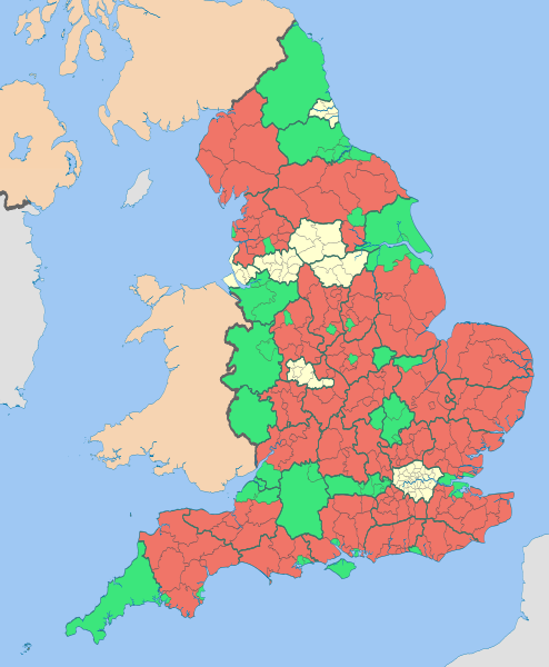
English: Map highlighting the non-metropolitan districts of England in 2009.
The thicker black lines are the ceremonial county boundaries. Equirectangular map projection on WGS 84 datum, with N/S stretched 170% Geographic limits:
|
| 日付 | (UTC) |
| 原典 |
このファイルの派生元: |
| 作者 |
|
| その他のバージョン |


この画像には画像編集が施されています。原本に対して次のデジタル的な変更が行われました。
|
ライセンス
このファイルはクリエイティブ・コモンズ 表示-継承 3.0 非移植ライセンスのもとに利用を許諾されています。
帰属: Nilfanion and Dr Greg
- あなたは以下の条件に従う場合に限り、自由に
- 共有 – 本作品を複製、頒布、展示、実演できます。
- 再構成 – 二次的著作物を作成できます。
- あなたの従うべき条件は以下の通りです。
- 表示 – あなたは適切なクレジットを表示し、ライセンスへのリンクを提供し、変更があったらその旨を示さなければなりません。これらは合理的であればどのような方法で行っても構いませんが、許諾者があなたやあなたの利用行為を支持していると示唆するような方法は除きます。
- 継承 – もしあなたがこの作品をリミックスしたり、改変したり、加工した場合には、あなたはあなたの貢献部分を元の作品とこれと同一または互換性があるライセンスの下に頒布しなければなりません。
元のアップロードログ
This image is a derivative work of the following images:
- File:English_districts_2010.svg licensed with Cc-by-sa-3.0, GFDL
- 2011-05-01T18:46:59Z Nilfanion 1108x1345 (512884 Bytes) == Summary == {{Information |Description=Map showing the all of the [[:w:Districts of England|Districts of England]] in 2010 Equirectangular map projection on WGS 84 datum, with N/S stretched 170% Geographic limits: *West:
- File:English_ceremonial_counties_2010.svg licensed with Cc-by-sa-3.0, GFDL
- 2010-11-23T16:39:55Z Nilfanion 1108x1345 (308868 Bytes) thicker lines
- 2010-11-23T16:20:19Z Nilfanion 1108x1345 (301520 Bytes) tweaks
- 2010-10-26T20:34:20Z Nilfanion 817x990 (1391832 Bytes) {{Information |Description=Map showing the [[w:ceremonial counties of England]] including the City of London, in 2010. Equirectangular map projection on WGS 84 datum, with N/S stretched 170% Geographic limits: *West: 6.75W
Uploaded with derivativeFX
ファイルの履歴
過去の版のファイルを表示するには、その版の日時をクリックしてください。
| 日付と時刻 | サムネイル | 寸法 | 利用者 | コメント | |
|---|---|---|---|---|---|
| 現在の版 | 2012年5月6日 (日) 12:18 | | 1,108 × 1,345 (658キロバイト) | Dr Greg | paler boundary lines |
| 2012年4月1日 (日) 21:11 |  | 1,108 × 1,345 (652キロバイト) | Dr Greg | {{Information |Description ={{en|1=see below}} |Source =see below |Author =see below |Date = |Permission = |other_versions = }} == {{int:filedesc}} == {{Information |Description={{en|Map highlighting the [[:w:non-metrop... |
ファイルの使用状況
このファイルを使用しているページはありません。