ファイル:Cleomenes War detail 1.svg

ページのコンテンツが他言語でサポートされていません。

元のファイル(SVG ファイル、343 × 360 ピクセル、ファイルサイズ: 931キロバイト)

概要

解説
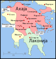
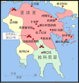
English: The Peleponnese (southernmost Greece) showing the larger powers and leagues at the time of the Cleomenean War (ca. 227 BC). The area in red shows the Achaean League.
日付
原典 投稿者自身による著作物
作者 MapMaster
その他のバージョン

[編集]

References

The map itself was built using a section of File:Greece map blank.svg. Towns were placed using geographic coordinates. There is some question where the ancient city of Messene was located. Maps (see "Greece under Theban Headship") place it well inland while the modern day Messene is close to the coast.

The borders of the various political entities were taken from several sources:

  • Chamoux, François (2002) Hellenistic civilization, Wiley-Blackwell, ISBN 9780631222422, p. 206, for the Achaean League.
  • Shepherd, William (1911) "Greece under Theban Headship", Historical Atlas, Henry Holt and Company. p. 17, was used as the primary reference for the Spartan borders. When there was a conflict with the Chamoux map, I used the Chamoux map.

Any additional information on borders and areas under control would be very welcome.

Similar maps

A larger overview map

ライセンス

この作品の著作権者である私は、この作品を以下のライセンスで提供します。
w:ja:クリエイティブ・コモンズ
表示 継承
このファイルはクリエイティブ・コモンズ 表示-継承 3.0 非移植ライセンスのもとに利用を許諾されています。
あなたは以下の条件に従う場合に限り、自由に
  • 共有 – 本作品を複製、頒布、展示、実演できます。
  • 再構成 – 二次的著作物を作成できます。
あなたの従うべき条件は以下の通りです。
  • 表示 – あなたは適切なクレジットを表示し、ライセンスへのリンクを提供し、変更があったらその旨を示さなければなりません。これらは合理的であればどのような方法で行っても構いませんが、許諾者があなたやあなたの利用行為を支持していると示唆するような方法は除きます。
  • 継承 – もしあなたがこの作品をリミックスしたり、改変したり、加工した場合には、あなたはあなたの貢献部分を元の作品とこれと同一または互換性があるライセンスの下に頒布しなければなりません。

キャプション

このファイルの内容を1行で記述してください

このファイルに描写されている項目

題材

10 1 2010

07e0781a946aad3cc9c4a76f1dc9a534f9dd30f3

953,648 バイト

360 ピクセル

343 ピクセル

ファイルの履歴

過去の版のファイルを表示するには、その版の日時をクリックしてください。

日付と時刻サムネイル寸法利用者コメント
現在の版2010年1月12日 (火) 04:352010年1月12日 (火) 04:35時点における版のサムネイル343 × 360 (931キロバイト)MapMasterAdded a few more cities and some clean-up
2010年1月11日 (月) 05:462010年1月11日 (月) 05:46時点における版のサムネイル343 × 360 (911キロバイト)MapMasterChanged town names to paths to properly render them
2010年1月11日 (月) 05:382010年1月11日 (月) 05:38時点における版のサムネイル343 × 360 (825キロバイト)MapMaster{{Information |Description={{en|1=The Peleponnese (southernmost Greece) showing the larger powers and leagues at the time of the Cleomenean War (ca. 227 BC). The area in red shows the Achaean League.}} |Source={{own}} |Author=MapMaster

以下のページがこのファイルを使用しています:

グローバルなファイル使用状況

以下に挙げる他のウィキがこの画像を使っています: