
ファイル:Brong Ahafo districts.png

このプレビューのサイズ: 776 × 600 ピクセル。 その他の解像度: 311 × 240 ピクセル | 621 × 480 ピクセル | 994 × 768 ピクセル | 1,056 × 816 ピクセル。
元のファイル (1,056 × 816 ピクセル、ファイルサイズ: 49キロバイト、MIME タイプ: image/png)
ウィキメディア・コモンズのファイルページにある説明を、以下に表示します。
|
概要
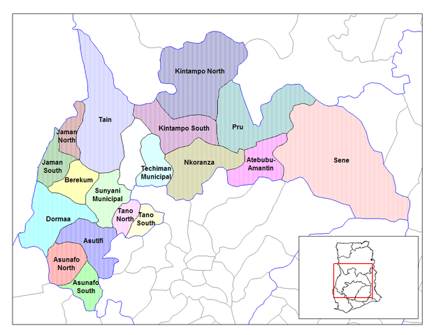
| 解説 | Map of the districts of the Brong Ahafo region of Ghana. Created by Rarelibra for public domain use. Created using MapInfo Professional v7.5 and various mapping resources. |
| 日付 | 2006年6月28日 (当初のアップロード日) |
| 原典 | コンピュータが読み取れる情報は提供されていませんが、投稿者自身による著作物だと推定されます(著作権の主張に基づく) |
| 作者 | コンピュータが読み取れる情報は提供されていませんが、Ahantaだと推定されます(著作権の主張に基づく) |
ライセンス
| この著作物の著作権者である私は、この著作物における権利を放棄しパブリックドメインとします。これは全世界で適用されます。 一部の国では、これが法的に可能ではない場合があります。その場合は、次のように宣言します。 私は、あらゆる人に対して、法により必要とされている条件を除き、如何なる条件も課すことなく、あらゆる目的のためにこの著作物を使用する権利を与えます。 |
ファイルの履歴
過去の版のファイルを表示するには、その版の日時をクリックしてください。
| 日付と時刻 | サムネイル | 寸法 | 利用者 | コメント | |
|---|---|---|---|---|---|
| 現在の版 | 2006年6月28日 (水) 10:27 | | 1,056 × 816 (49キロバイト) | Ahanta | Map of the districts of the Brong Ahafo region of Ghana. Created by Rarelibra for public domain use. Created using MapInfo Professional v7.5 and various mapping resources. [edit] I, the creator of this work, hereby release it into the public domain. This |
ファイルの使用状況
このファイルを使用しているページはありません。
グローバルなファイル使用状況
以下に挙げる他のウィキがこの画像を使っています:
- ca.wikipedia.org での使用状況
- ceb.wikipedia.org での使用状況
- dag.wikipedia.org での使用状況
- da.wikipedia.org での使用状況
- de.wikipedia.org での使用状況
- dga.wikipedia.org での使用状況
- en.wikipedia.org での使用状況
- Dormaa District
- Asutifi District
- Nkoranza District
- Sene District
- Atebubu District
- Pru District
- Jaman District
- Berekum-Jaman District
- Kintampo District
- Asunafo District
- User talk:Rarelibra/Maps2
- List of hospitals in Ghana
- List of Ghana Parliament constituencies
- Nsoatre
- User:GerardM/Districts of Ghana
- Tano District, Ghana
- es.wikipedia.org での使用状況
- fa.wikipedia.org での使用状況
- frr.wikipedia.org での使用状況
- fr.wikipedia.org での使用状況
このファイルのグローバル使用状況を表示する。