
ファイル:Bread street ward and Cordwainer ward 1720 john stow with streets highlighted.jpg
このプレビューのサイズ: 800 × 462 ピクセル。 その他の解像度: 320 × 185 ピクセル | 640 × 370 ピクセル | 1,059 × 612 ピクセル。
元のファイル (1,059 × 612 ピクセル、ファイルサイズ: 249キロバイト、MIME タイプ: image/jpeg)
ウィキメディア・コモンズのファイルページにある説明を、以下に表示します。
|
| 解説 |
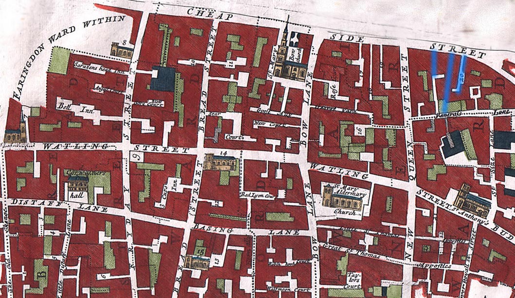
English: The Wards of Breadstreet and Cordwainer
The overlaid streets are from Holt, Richard; Baker, Nigel (2001), Lynne Bevan, ed., Indecent Exposure - sexuality, society and the archaeological record - Prostitution in English Medieval Towns, Glasgow: Cruithne Press, ISBN 1-873448-19-8Including Bow Lane, Friday Street, New Queen St., Watling St, Distaff Lane and Budge Row. Grope Countelane in the middle (blue) is bordered by Bordhawlane on the right, and Puppekirtylane on the left. Although these streets are mostly gone, the map does demonstrate the number of narrow streets in the area. The 1720 map is from John Stow (John Strype, editor), Survey of the Cities of London and Westminster London, 1720, 2 volumes |
| 日付 | |
| 原典 | http://www.oldlondonmaps.com/stowpages/broad.html |
| 作者 | John Stow |
ライセンス
|
この著作物は、著作権の保護期間が著作者の死後100年以下である国・地域においてパブリックドメインの状態にあります。 この著作物は1929年1月1日以前に公表され、又はアメリカ合衆国著作権局に登録されたため、アメリカ合衆国においてパブリックドメインの状態にあります。 | |
| このファイルは著作権法の既知の制約(隣接権や関連する権利を含む)から自由であると特定されています。 | |
ファイルの履歴
過去の版のファイルを表示するには、その版の日時をクリックしてください。
| 日付と時刻 | サムネイル | 寸法 | 利用者 | コメント | |
|---|---|---|---|---|---|
| 現在の版 | 2009年4月21日 (火) 13:37 | | 1,059 × 612 (249キロバイト) | Parrot of Doom | {{Information |Description={{en|1=== Summary == {{Information |Description={{en|1=The Wards of Breadstreet and Cordwainer Including Bow Lane, Friday Street, New Queen St., Watling St, Distaff Lane and Budge Row from John Stow (John Strype, editor), Surv |
ファイルの使用状況
以下のページがこのファイルを使用しています:
グローバルなファイル使用状況
以下に挙げる他のウィキがこの画像を使っています:
- en.wikipedia.org での使用状況
- es.wikipedia.org での使用状況
- fr.wikipedia.org での使用状況
- it.wikipedia.org での使用状況
- pt.wikipedia.org での使用状況
- www.wikidata.org での使用状況