
ファイル:Bastogne Map December 19-23 1944.jpg
このプレビューのサイズ: 800 × 477 ピクセル。 その他の解像度: 320 × 191 ピクセル | 640 × 381 ピクセル | 1,024 × 610 ピクセル | 1,556 × 927 ピクセル。
元のファイル (1,556 × 927 ピクセル、ファイルサイズ: 1.19メガバイト、MIME タイプ: image/jpeg)
ウィキメディア・コモンズのファイルページにある説明を、以下に表示します。
|
概要
| 記述 | ||||||||||
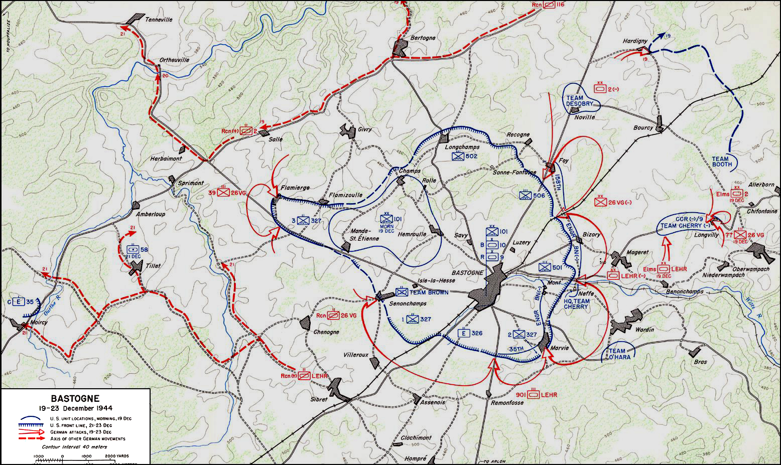
| 日付 | ||||||||||
| 原典 | アメリカ合衆国陸軍戦史センター | |||||||||
| 作者 | ||||||||||
| Geotemporal data | ||||||||||
| 記載日付 | 1944年12月19日から1944年12月23日まで | |||||||||
| Map location | バストーニュ | |||||||||
| Heading |
 |
|||||||||
| Bounding box |
|
|||||||||
| Georeferencing | ||||||||||

|
このmilitary map画像は、ベクターイメージである SVG ファイルとして再作成されるべきです。これにはいくつかの利点があります。詳しくはCommons:Media for cleanupを参照してください。この画像の SVG 形式がすでに利用可能である場合は、アップロードしてください。アップロード後、この画像にあるこのテンプレートを{{Vector version available|新しい画像ファイル名.svg}}テンプレートで置き換えてください。
|


ライセンス
| This image is in the public domain because it contains materials that originally came from the United States Army Center of Military History, subject to the following qualification.
Note: The images of all badges, insignia, decorations and medals on the "CMH Online" web site are produced by the United States Army Institute of Heraldry and protected by Title 18, United States Code, Section 704 and the Code of Federal Regulations (32 CFR, Part 507). Permission to use these images for commercial purposes must be obtained from The Institute of Heraldry prior to their use. |

|
ファイルの履歴
過去の版のファイルを表示するには、その版の日時をクリックしてください。
| 日付と時刻 | サムネイル | 寸法 | 利用者 | コメント | |
|---|---|---|---|---|---|
| 現在の版 | 2006年11月4日 (土) 04:59 | | 1,556 × 927 (1.19メガバイト) | CORNELIUSSEON | {{Information |Description=Bastogne, Belgium Map; december 19-23, 1944. |Source=US Army Center for Military History |Date=December 19-23, 1944 |Author= |Permission={{PD-USGov-Military-Army-USACMH}} – US Army Center for Military History |other_versions= |
ファイルの使用状況
以下のページがこのファイルを使用しています:
グローバルなファイル使用状況
以下に挙げる他のウィキがこの画像を使っています:
- ar.wikipedia.org での使用状況
- ca.wikipedia.org での使用状況
- de.wikipedia.org での使用状況
- el.wikipedia.org での使用状況
- en.wikipedia.org での使用状況
- en.wikisource.org での使用状況
- es.wikipedia.org での使用状況
- he.wikipedia.org での使用状況
- it.wikipedia.org での使用状況
- nl.wikipedia.org での使用状況
- ru.wikipedia.org での使用状況
- sl.wikipedia.org での使用状況
- ta.wikipedia.org での使用状況
- tr.wikipedia.org での使用状況
- www.wikidata.org での使用状況
- zh.wikipedia.org での使用状況