
ファイル:AchaemenidMapBehistunInscription.png

このプレビューのサイズ: 800 × 511 ピクセル。 その他の解像度: 320 × 205 ピクセル | 640 × 409 ピクセル | 1,020 × 652 ピクセル。
元のファイル (1,020 × 652 ピクセル、ファイルサイズ: 17キロバイト、MIME タイプ: image/png)
ウィキメディア・コモンズのファイルページにある説明を、以下に表示します。
|
概要
| 解説 |
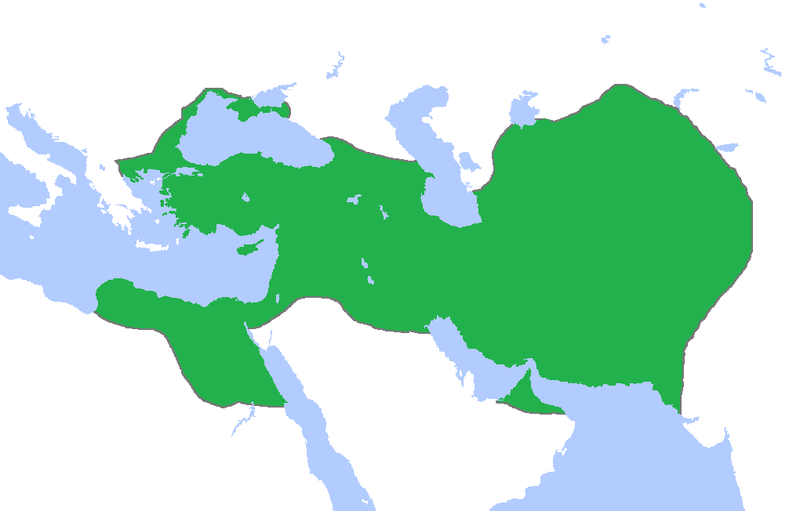
English: This a map of the Achaemenid Empire showing its greatest extent. I have given it more regions as listed on the Behistun Inscription the Persian King Darius wrote telling his conquests. |
| 日付 | |
| 原典 | http://en.wikipedia.org/wiki/File:Achemenids500BC.png |
| 作者 | Gabagool |
| 許可 (ファイルの再利用) |
http://en.wikipedia.org/wiki/File:Achemenids500BC.png |
- Other information
English: This is a map I have edited from that map and it says that I am free to share, to remix, but under the following conditions that i must the work in the manner specified by the author or licensor.
このファイルはクリエイティブ・コモンズ 表示 1.0 一般ライセンスのもとに利用を許諾されています。
- あなたは以下の条件に従う場合に限り、自由に
- 共有 – 本作品を複製、頒布、展示、実演できます。
- 再構成 – 二次的著作物を作成できます。
- あなたの従うべき条件は以下の通りです。
- 表示 – あなたは適切なクレジットを表示し、ライセンスへのリンクを提供し、変更があったらその旨を示さなければなりません。これらは合理的であればどのような方法で行っても構いませんが、許諾者があなたやあなたの利用行為を支持していると示唆するような方法は除きます。
ライセンス
このファイルはクリエイティブ・コモンズ 表示 3.0 非移植ライセンスのもとに利用を許諾されています。
- あなたは以下の条件に従う場合に限り、自由に
- 共有 – 本作品を複製、頒布、展示、実演できます。
- 再構成 – 二次的著作物を作成できます。
- あなたの従うべき条件は以下の通りです。
- 表示 – あなたは適切なクレジットを表示し、ライセンスへのリンクを提供し、変更があったらその旨を示さなければなりません。これらは合理的であればどのような方法で行っても構いませんが、許諾者があなたやあなたの利用行為を支持していると示唆するような方法は除きます。
ファイルの履歴
過去の版のファイルを表示するには、その版の日時をクリックしてください。
| 日付と時刻 | サムネイル | 寸法 | 利用者 | コメント | |
|---|---|---|---|---|---|
| 現在の版 | 2015年10月23日 (金) 00:53 | | 1,020 × 652 (17キロバイト) | LouisAragon | blocked sock. |
| 2015年10月13日 (火) 02:01 |  | 1,020 × 652 (22キロバイト) | History of Persia | My apologies sir but they did conquer parts of arabia. See the Achaemenid Arabia article. | |
| 2015年10月13日 (火) 01:50 |  | 1,020 × 652 (17キロバイト) | LouisAragon | Reverted to version as of 22:39, 6 February 2015 (UTC) | |
| 2015年10月13日 (火) 01:24 |  | 1,020 × 652 (22キロバイト) | LouisAragon | correct. | |
| 2015年10月13日 (火) 01:21 |  | 1,020 × 652 (22キロバイト) | LouisAragon | They simply did not conquer those territories you just added on all sides. | |
| 2015年9月8日 (火) 23:28 |  | 1,012 × 648 (19キロバイト) | History of Persia | More accurate map. info on greek territories: File:Map Greco-Persian Wars-en.svg, size of Mascat (modern Oman/UAE): File:East-Hem 600bc.jpg. clay tablets in old persian have been found in bahrain, so its likely they were part of the achaemenid empire,... | |
| 2015年7月29日 (水) 00:48 |  | 1,020 × 652 (20キロバイト) | History of Persia | made achaemenid arabia better | |
| 2015年7月9日 (木) 00:25 |  | 1,020 × 652 (22キロバイト) | History of Persia | They had also conquered arabia-petrea (though it did not exist with that name) A wikipedia article of the province exists: Achaemenid Arabia | |
| 2015年2月6日 (金) 22:39 |  | 1,020 × 652 (17キロバイト) | HistoryofIran | I aprreciete your effort, but could you please upload the picture instead of replacing it with mine? thanks. | |
| 2015年1月29日 (木) 04:55 |  | 1,020 × 652 (59キロバイト) | Javierfv1212 | Updated the map by delineating the conquests of the three major Persian conqueror Kings, and also adding the names of the main satrapies of the empire. As a source I used this map of Ian Mladjov's Resources from the University of Michigan's History dep... |
ファイルの使用状況
以下のページがこのファイルを使用しています:
グローバルなファイル使用状況
以下に挙げる他のウィキがこの画像を使っています:
- ar.wikipedia.org での使用状況
- be.wikipedia.org での使用状況
- da.wikipedia.org での使用状況
- en.wikipedia.org での使用状況
- en.wikivoyage.org での使用状況
- eo.wikipedia.org での使用状況
- es.wikipedia.org での使用状況
- fa.wikipedia.org での使用状況
- fr.wikipedia.org での使用状況
- gl.wikipedia.org での使用状況
- hu.wikipedia.org での使用状況
- hy.wikipedia.org での使用状況
- id.wikibooks.org での使用状況
- incubator.wikimedia.org での使用状況
- it.wikipedia.org での使用状況
- it.wikiversity.org での使用状況
- la.wikipedia.org での使用状況
- li.wikipedia.org での使用状況
- mg.wikipedia.org での使用状況
- ms.wikipedia.org での使用状況
- no.wikipedia.org での使用状況
- pl.wikipedia.org での使用状況
- pnb.wikipedia.org での使用状況
- ps.wikipedia.org での使用状況
- ru.wikipedia.org での使用状況
- simple.wikipedia.org での使用状況
- sr.wikipedia.org での使用状況
- te.wikipedia.org での使用状況
- th.wikipedia.org での使用状況
- tr.wikipedia.org での使用状況
- tt.wikipedia.org での使用状況
このファイルのグローバル使用状況を表示する。