
ファイル:Çorum districts.png

このプレビューのサイズ: 776 × 600 ピクセル。 その他の解像度: 311 × 240 ピクセル | 621 × 480 ピクセル | 994 × 768 ピクセル | 1,056 × 816 ピクセル。
元のファイル (1,056 × 816 ピクセル、ファイルサイズ: 36キロバイト、MIME タイプ: image/png)
ウィキメディア・コモンズのファイルページにある説明を、以下に表示します。
|
概要
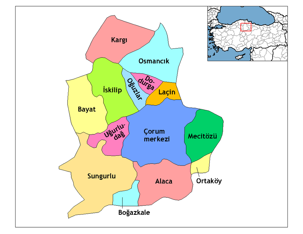
Description=Map of the districts of Çorum province in Turkey. Source= Image:Çorum__districts.png Author= User:Rarelibra,1 December 2006 (UTC) for public domain use, using MapInfo Professional v8.5 and various mapping resources. Edited by One Homo Sapiens Corrected text where İ,Ş,ı,ğ,or ş occurs in name. Source: [statoids-com]. Increased font size and enhanced color differences among adjacent districts. , reload by User:Mustafa_Akalp to match the Province name in en:wiki.
| この著作物の著作権者である私は、この著作物における権利を放棄しパブリックドメインとします。これは全世界で適用されます。 一部の国では、これが法的に可能ではない場合があります。その場合は、次のように宣言します。 私は、あらゆる人に対して、法により必要とされている条件を除き、如何なる条件も課すことなく、あらゆる目的のためにこの著作物を使用する権利を与えます。 |
ライセンス
この作品の著作権者である私は、この作品を以下のライセンスで提供します。

|
この文書は、フリーソフトウェア財団発行のGNUフリー文書利用許諾書 (GNU Free Documentation License) 1.2またはそれ以降のバージョンの規約に基づき、複製や再配布、改変が許可されます。不可変更部分、表紙、背表紙はありません。このライセンスの複製は、GNUフリー文書利用許諾書という章に含まれています。 |
| このファイルはクリエイティブ・コモンズ 表示-継承 3.0 非移植ライセンスのもとに利用を許諾されています。 | ||
| ||
| このライセンスのテンプレートは、GFDLのライセンス・アップデートによりこのファイルに追加されたものです。 |
あなたは上記のライセンスから、どれか一つ以上を選択できます。
ファイルの履歴
過去の版のファイルを表示するには、その版の日時をクリックしてください。
| 日付と時刻 | サムネイル | 寸法 | 利用者 | コメント | |
|---|---|---|---|---|---|
| 現在の版 | 2008年12月29日 (月) 04:24 | | 1,056 × 816 (36キロバイト) | One Homo Sapiens | Corrected text where İ,Ş,ı,ğ,or ş occurs in name. Source: [statoids-com]. Increased font size and enhanced color differences among adjacent districts. |
| 2007年2月2日 (金) 05:38 |  | 1,056 × 816 (45キロバイト) | Makalp | Description=Map of the districts of Çorum province in Turkey. Source= Image:Çorum__districts.png Author= User:Rarelibra,1 December 2006 (UTC) for public domain use, using MapInfo Professional v8.5 and various mapping resources. , reloa |
ファイルの使用状況
以下のページがこのファイルを使用しています:
グローバルなファイル使用状況
以下に挙げる他のウィキがこの画像を使っています:
- arz.wikipedia.org での使用状況
- ast.wikipedia.org での使用状況
- ca.wikipedia.org での使用状況
- ce.wikipedia.org での使用状況
- cs.wikipedia.org での使用状況
- de.wikipedia.org での使用状況
- de.wikivoyage.org での使用状況
- diq.wikipedia.org での使用状況
- en.wikipedia.org での使用状況
- Çorum Province
- User talk:Rarelibra/Maps4
- Districts of Turkey
- Governor of Çorum
- List of populated places in Çorum Province
- Ortaköy District, Çorum
- Uğurludağ District
- Alaca District
- Çorum District
- Bayat District, Çorum
- Boğazkale District
- Dodurga District
- İskilip District
- Kargı District
- Laçin District
- Mecitözü District
- Oğuzlar District
- Osmancık District
- Sungurlu District
- en.wiktionary.org での使用状況
- eo.wikipedia.org での使用状況
- es.wikipedia.org での使用状況
このファイルのグローバル使用状況を表示する。