
ファイル:Soo Line.png
このプレビューのサイズ: 800 × 577 ピクセル。 その他の解像度: 320 × 231 ピクセル | 640 × 462 ピクセル | 1,024 × 739 ピクセル | 1,074 × 775 ピクセル。
元のファイル (1,074 × 775 ピクセル、ファイルサイズ: 93キロバイト、MIME タイプ: image/png)
ウィキメディア・コモンズのファイルページにある説明を、以下に表示します。
|
概要
| 解説 |
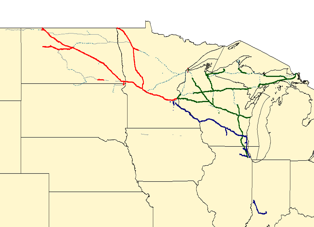
English: Map of the en:Soo Line Railroad. Red lines are former SOO trackage operated by en:CP Rail; dark blue lines are former Milwaukee Road trackage now operated by en:CP Rail; green lines are former SOO trackage spun off to the en:Wisconsin Central Railway and now part of en:Canadian National. Grey lines in North Dakota are operated by Short Lines (Dakota Missouri Valley & Western or Northern Plains Railroads). Dotted light blue lines are abandoned.
Created with Quantum GIS using data from the National Transportation Atlas. |
| 日付 | 2006年9月3日 (当初のアップロード日) |
| 原典 |
en.wikipedia からコモンズに移動されました。 |
| 作者 | Original uploader was Elkman (talk) at en.wikipedia |
ライセンス
この作品の著作権者であるElkman at the English language Wikipediaは、この作品を以下のライセンスで提供しています。

|
この文書は、フリーソフトウェア財団発行のGNUフリー文書利用許諾書 (GNU Free Documentation License) 1.2またはそれ以降のバージョンの規約に基づき、複製や再配布、改変が許可されます。不可変更部分、表紙、背表紙はありません。このライセンスの複製は、GNUフリー文書利用許諾書という章に含まれています。 著作権に示した解釈の下ライセンスされるものとします。 |
帰属: Elkman at the English language Wikipedia
- あなたは以下の条件に従う場合に限り、自由に
- 共有 – 本作品を複製、頒布、展示、実演できます。
- 再構成 – 二次的著作物を作成できます。
- あなたの従うべき条件は以下の通りです。
- 表示 – あなたは適切なクレジットを表示し、ライセンスへのリンクを提供し、変更があったらその旨を示さなければなりません。これらは合理的であればどのような方法で行っても構いませんが、許諾者があなたやあなたの利用行為を支持していると示唆するような方法は除きます。
- 継承 – もしあなたがこの作品をリミックスしたり、改変したり、加工した場合には、あなたはあなたの貢献部分を元の作品とこれと同一または互換性があるライセンスの下に頒布しなければなりません。
あなたは上記のライセンスから、どれか一つ以上を選択できます。
元のアップロードログ
元のファイルページはこちら。以下の利用者は全てen.wikipediaに属します。
- 2006-09-03 17:55 Elkman 1074×775× (95338 bytes) Map of the [[Soo Line Railroad]]. Red lines are former SOO trackage operated by [[CP Rail]]; dark blue lines are former Milwaukee Road trackage now operated by [[CP Rail]]; green lines are former SOO trackage spun off to the [[Wisconsin Central Railway]]
ファイルの履歴
過去の版のファイルを表示するには、その版の日時をクリックしてください。
| 日付と時刻 | サムネイル | 寸法 | 利用者 | コメント | |
|---|---|---|---|---|---|
| 現在の版 | 2009年3月14日 (土) 11:47 | | 1,074 × 775 (93キロバイト) | 手練~commonswiki | {{Information |Description={{en|Map of the en:Soo Line Railroad. Red lines are former SOO trackage operated by en:CP Rail; dark blue lines are former Milwaukee Road trackage now operated by en:CP Rail; green lines are former SOO trackage s |
ファイルの使用状況
以下のページがこのファイルを使用しています:
グローバルなファイル使用状況
以下に挙げる他のウィキがこの画像を使っています:
- en.wikipedia.org での使用状況
- fr.wikipedia.org での使用状況
- it.wikipedia.org での使用状況
- nl.wikipedia.org での使用状況