
Pont-Audemer
Pont-Audemer | |
|---|---|
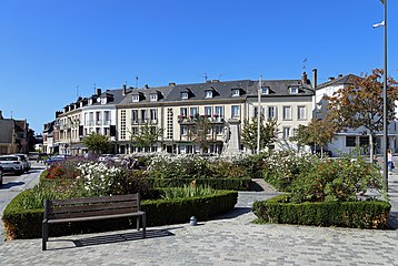
 Pont-Audemer: Rue de la République | |
.svg) Coat of arms | |
Location of Pont-Audemer  | |
 Pont-Audemer  Pont-Audemer | |
| Coordinates: 49°21′23″N 00°30′56″E / 49.35639°N 0.51556°E | |
| Country | France |
| Region | Normandy |
| Department | Eure |
| Arrondissement | Bernay |
| Canton | Pont-Audemer |
| Intercommunality | Pont-Audemer / Val de Risle |
| Government | |
| • Mayor (2022–2026) | Alexis Darmois[1] |
| Area 1 | 14.66 km2 (5.66 sq mi) |
| Population (2021)[2] | 9,848 |
| • Density | 670/km2 (1,700/sq mi) |
| Time zone | UTC+01:00 (CET) |
| • Summer (DST) | UTC+02:00 (CEST) |
| INSEE/Postal code | 27467 /27500 |
| Elevation | 2–115 m (6.6–377.3 ft) (avg. 9 m or 30 ft) |
| 1 French Land Register data, which excludes lakes, ponds, glaciers > 1 km2 (0.386 sq mi or 247 acres) and river estuaries. | |
Pont-Audemer (French pronunciation: [pɔ̃.t‿odmɛʁ]) is a commune in the Eure department in the Normandy region in northern France.[3] On 1 January 2018, the former commune of Saint-Germain-Village was merged into Pont-Audemer.[4]
Geography[edit]
The commune is situated on the river Risle, 13 km upstream from its outflow into the Seine. It lies on the border between the regions Roumois and Lieuvin.
Population[edit]
The population data in the table below refer to the commune of Pont-Audemer proper, in its geography at the given years. The commune of Pont-Audemer absorbed part of the former commune of Saint-Agnan in 1835, Saint-Paul-sur-Risle in 1963 and Saint-Germain-Village in 2018.[5][3]
|
| ||||||||||||||||||||||||||||||||||||||||||||||||||||||||||||||||||||||||||||||||||||||||||||||||||||||||||||||||||
| Source: EHESS[5] and INSEE (2007-2021)[6][7] | |||||||||||||||||||||||||||||||||||||||||||||||||||||||||||||||||||||||||||||||||||||||||||||||||||||||||||||||||||
Sights[edit]
The commune was spared substantial damage to its historic buildings during the Battle of Normandy. Nowadays the half-timbered buildings and the canals running between them are a tourist attraction. The church of Saint-Ouen is noted for its Renaissance stained glass.
Personalities[edit]
- Laetitia Casta, supermodel, was born there in 1978.
- Hervé Morin, politician, former French Minister of Defence was born there in 1961.
- Alexis Vastine, boxer, was born there in 1986.
Transport[edit]
Pont-Audemer has a railway station, Gare de Pont-Audemer, but passenger services were ceased in 1969. The station is served by TER Haute-Normandie buses. PontAuRail, a heritage railway association, ran two Diesel multiple units (a X4500 and a X2400) from Pont-Audemer to Honfleur between 1995 and 2006.
Administration[edit]
Until 1926, Pont-Audemer was a sub-prefecture of the Eure department.
Media[edit]
The city is evoked in a poem of Paul Verlaine called "The Apollo of Pont-Audemer." The area is included in Ted Fahrenwald's book "Bailout Over Normandy: A Flyboy's Adventures" as the site where he met Riri, his sweetheart.
Twin towns - sister cities[edit]
Pont-Audemer is twinned with:
 Ringwood in England
 Veghel in the Netherlands
Gallery[edit]
-
 Place Louis Gillain
 -
 War memorial
 -
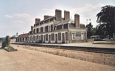 Train station
 -
 The X2426 at Pont-Audemer Station


See also[edit]
References[edit]
- ^ "Répertoire national des élus: les maires" (in French). data.gouv.fr, Plateforme ouverte des données publiques françaises. 4 May 2022.
- ^ "Populations légales 2021". The National Institute of Statistics and Economic Studies. 28 December 2023.
- ^ a b Commune de Pont-Audemer (27467), INSEE
- ^ Arrêté préfectoral 6 December 2017 (in French)
- ^ a b Des villages de Cassini aux communes d'aujourd'hui: Commune data sheet Pont-Audemer, EHESS (in French).
- ^ Populations légales 2012, INSEE
- ^ Populations légales 2021: 27 Eure, INSEE
This Eure geographical article is a stub. You can help Wikipedia by expanding it. |