
ファイル:Wpdms aq block 1614.jpg

このプレビューのサイズ: 429 × 599 ピクセル。 その他の解像度: 172 × 240 ピクセル | 344 × 480 ピクセル | 550 × 768 ピクセル | 733 × 1,024 ピクセル | 1,466 × 2,048 ピクセル | 5,744 × 8,021 ピクセル。
元のファイル (5,744 × 8,021 ピクセル、ファイルサイズ: 7.61メガバイト、MIME タイプ: image/jpeg)
ウィキメディア・コモンズのファイルページにある説明を、以下に表示します。
|
概要
| 記述 |
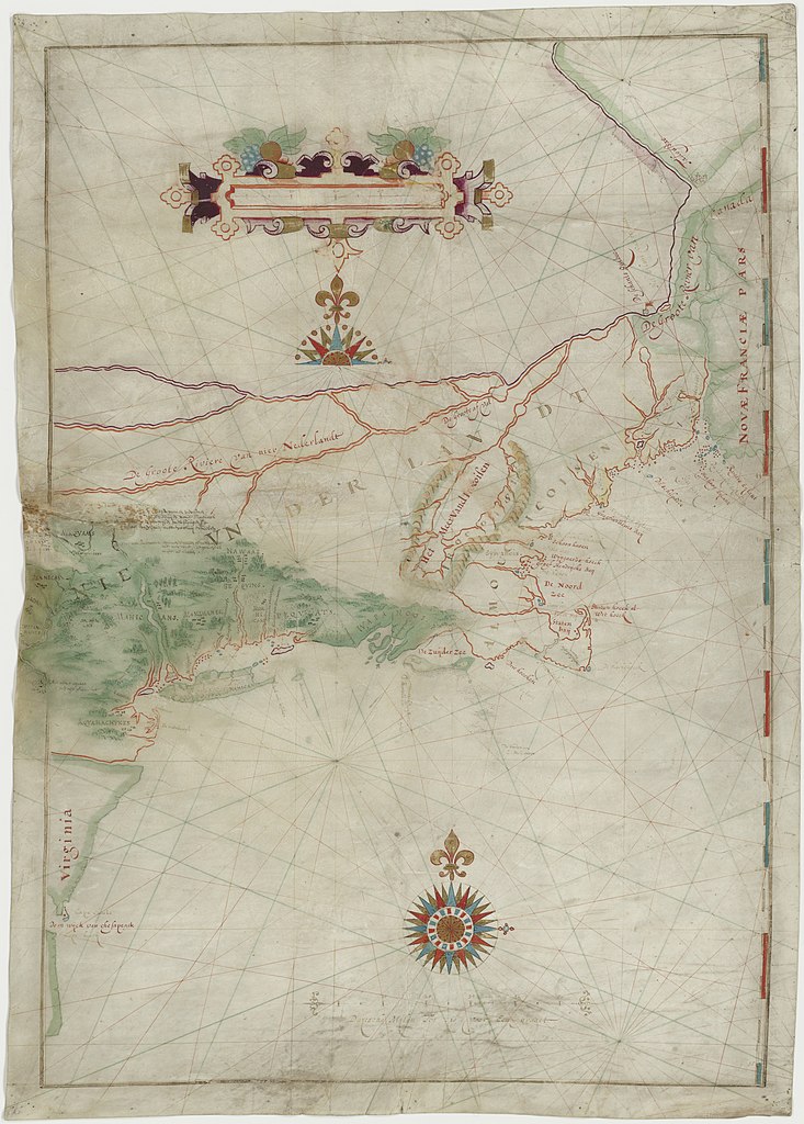
English: Map made by w:Adriaen Block of his 1614 expedition to North America. It is the first map to show Long Island as an island. It is also the first appearance of the term New Netherland to describe the colony (17th century drawing). |
|||||||||
| 日付 | ||||||||||
| 原典 | digitalized by the Dutch National Archive (perm link) | |||||||||
| 作者 | ||||||||||
| Geotemporal data | ||||||||||
| Bounding box |
|
|||||||||
| Georeferencing | ||||||||||
| その他のバージョン | File:The figurative map of Adriaen Block (NYPL Hades-118535-54659).tif | |||||||||
ライセンス
|
このファイルは、パブリックドメインの状態にある平面的な美術の著作物を写真術によって忠実に複製したものです。このような複製はアメリカ合衆国においてパブリックドメインの状態にあります。その他の地域では再利用に制限がかかる場合があります。詳しくはReuse of PD-Art photographsをご覧ください。美術の著作物としての原図は、次の理由によりパブリックドメインの状態にあります。
| ||||
ファイルの履歴
過去の版のファイルを表示するには、その版の日時をクリックしてください。
| 日付と時刻 | サムネイル | 寸法 | 利用者 | コメント | |
|---|---|---|---|---|---|
| 現在の版 | 2021年5月18日 (火) 18:41 | | 5,744 × 8,021 (7.61メガバイト) | Ciell | Larger digitalisation from the Dutch National Archive |
| 2012年2月17日 (金) 17:15 |  | 456 × 640 (104キロバイト) | Gladiool | Better quality version of the same image. Found at [http://www.stonybrook.edu/libmap/coordinates/seriesa/no5/block.jpg]. | |
| 2005年9月28日 (水) 21:00 |  | 350 × 499 (31キロバイト) | Longbow4u | *Description:Map made by w:Adriaen Block of his 1614 expedition to North America. It is the first map to show Long Island as an island. It is also the first appearance of the term New Netherland to describe the colony (17th century drawing). *Sour |
ファイルの使用状況
以下の 2 ページがこのファイルを使用しています:
グローバルなファイル使用状況
以下に挙げる他のウィキがこの画像を使っています:
- af.wikipedia.org での使用状況
- azb.wikipedia.org での使用状況
- be.wikipedia.org での使用状況
- ca.wikipedia.org での使用状況
- de.wikipedia.org での使用状況
- en.wikipedia.org での使用状況
- es.wikipedia.org での使用状況
- et.wikipedia.org での使用状況
- fa.wikipedia.org での使用状況
- fr.wikipedia.org での使用状況
- fy.wikipedia.org での使用状況
- hr.wikipedia.org での使用状況
- is.wikipedia.org での使用状況
- it.wikipedia.org での使用状況
- ml.wikipedia.org での使用状況
- nl.wikipedia.org での使用状況
- ru.wikipedia.org での使用状況
- sh.wikipedia.org での使用状況
- uk.wikipedia.org での使用状況
- zh.wikipedia.org での使用状況