
ファイル:Western Han Mawangdui Silk Map.JPG

このプレビューのサイズ: 621 × 600 ピクセル。 その他の解像度: 249 × 240 ピクセル | 497 × 480 ピクセル | 795 × 768 ピクセル | 1,060 × 1,024 ピクセル | 2,121 × 2,048 ピクセル | 3,675 × 3,549 ピクセル。
元のファイル (3,675 × 3,549 ピクセル、ファイルサイズ: 3.07メガバイト、MIME タイプ: image/jpeg)
ウィキメディア・コモンズのファイルページにある説明を、以下に表示します。
|
概要
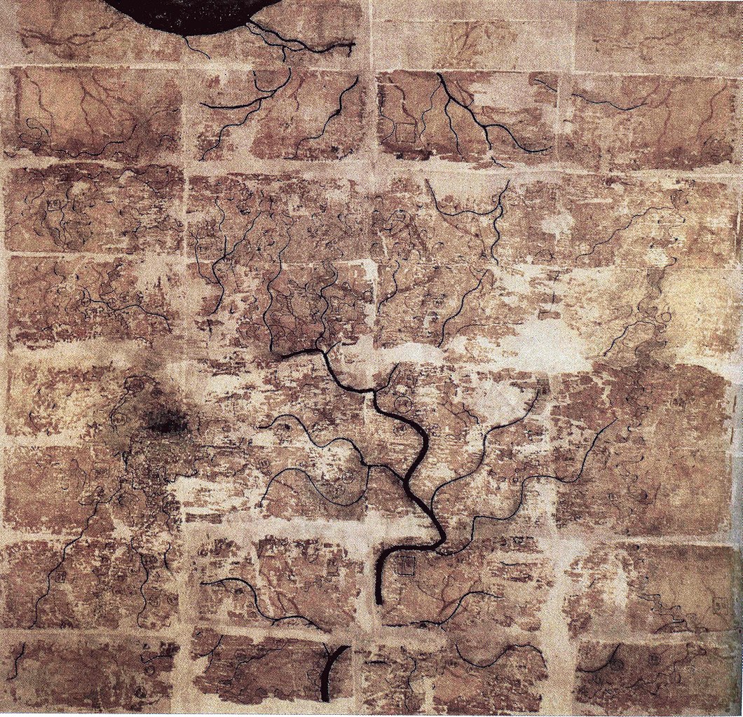
| 解説 | A Chinese topographic map (with the south positioned at the top) from Mawangdui tomb 3; dated to the early Western Han period (183–168 BC); length is 96 cm; width is 96 cm; the map is made of ink on silk. It is now housed in the Hunan Provincial Museum, Changsha. The map depicts a large territory in southern China spanning from the imperial fiefdom of Changsha (a semi-autonomous kingdom within the Han Empire, now modern-day Hunan) to the independent and sometimes hostile Kingdom of Nanyue in what is now modern-day Guangdong and northern Vietnam. |
| 日付 | 2nd century BC (anywhere from 183 to 168 BC) |
| 原典 | Scanned from Barbieri-Low, Anthony J. (2007). Artisans in Early Imperial China. Seattle and London: University of Washington Press. ISBN 0295987138. Page 174. |
| 作者 | Anonymous ancient Chinese cartographer |
| その他のバージョン | このファイルの派生的著作物: Cypraea mappa map comparison.jpg |
ライセンス
|
このファイルは、パブリックドメインの状態にある平面的な美術の著作物を写真術によって忠実に複製したものです。このような複製はアメリカ合衆国においてパブリックドメインの状態にあります。その他の地域では再利用に制限がかかる場合があります。詳しくはReuse of PD-Art photographsをご覧ください。美術の著作物としての原図は、次の理由によりパブリックドメインの状態にあります。
| ||||
ファイルの履歴
過去の版のファイルを表示するには、その版の日時をクリックしてください。
| 日付と時刻 | サムネイル | 寸法 | 利用者 | コメント | |
|---|---|---|---|---|---|
| 現在の版 | 2018年5月10日 (木) 22:58 | | 3,675 × 3,549 (3.07メガバイト) | Soerfm | Brightness, color, crop. |
| 2009年4月27日 (月) 22:10 |  | 3,675 × 3,549 (2.89メガバイト) | PericlesofAthens | {{Information |Description=A Chinese topographic map (with the south positioned at the top) from Mawangdui tomb 3; dated to the early Western Han period (183–168 BC); length is 96 cm; width is 96 cm; the map is made of ink on silk. It is now housed |
ファイルの使用状況
グローバルなファイル使用状況
以下に挙げる他のウィキがこの画像を使っています:
- als.wikipedia.org での使用状況
- ca.wikipedia.org での使用状況
- de.wikipedia.org での使用状況
- en.wikipedia.org での使用状況
- es.wikipedia.org での使用状況
- fi.wikipedia.org での使用状況
- fr.wikipedia.org での使用状況
- hr.wikipedia.org での使用状況
- id.wikipedia.org での使用状況
- it.wikipedia.org での使用状況
- km.wikipedia.org での使用状況
- ko.wikipedia.org での使用状況
- mwl.wikipedia.org での使用状況
- nl.wikipedia.org での使用状況
- pl.wikipedia.org での使用状況
- pnb.wikipedia.org での使用状況
- pt.wikipedia.org での使用状況
- ro.wikipedia.org での使用状況
- ru.wikipedia.org での使用状況
- sh.wikipedia.org での使用状況
- sl.wikipedia.org での使用状況
このファイルのグローバル使用状況を表示する。