
ファイル:The Carte of all the Coast of Virginia by Theodor de Bry 1585 1586.jpg

このプレビューのサイズ: 800 × 591 ピクセル。 その他の解像度: 320 × 236 ピクセル | 640 × 473 ピクセル | 1,000 × 739 ピクセル。
元のファイル (1,000 × 739 ピクセル、ファイルサイズ: 247キロバイト、MIME タイプ: image/jpeg)
ウィキメディア・コモンズのファイルページにある説明を、以下に表示します。
|
概要
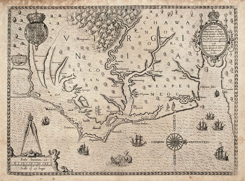
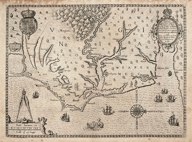
| セオドア・ド・ブライ: The Carte of All the Coast of Virginia
( |
||||||||||||||||||||||||
|---|---|---|---|---|---|---|---|---|---|---|---|---|---|---|---|---|---|---|---|---|---|---|---|---|
| 作者 |
|
|||||||||||||||||||||||
| タイトル |
The Carte of All the Coast of Virginia |
|||||||||||||||||||||||
| 解説 |
English: "The Carte of All the Coast of Virginia," engraving by Theodor de Bry based on John White's map of the coast of Virginia and North Carolina circa 1585-1586. de Bry's engraving was published in Thomas Hariot's "A Briefe and True Report of the New Found Land of Virginia," published in 1588 and in Vol. 1 of Theodore de Bry’s Great Voyages, printed in French, English and German. This was the first printed map with a high degree of detail and accuracy for any part of the United States. It was the first separate map of Virginia. It was based on a manuscript map by John White from 1585, a copy of which is in the British Museum, revised for additional names and coastal detail gained from Roanoke Colony travels in 1587 and 1588. Quinn notes that White’s original drawing is accepted as the major contemporary authority on the configuration of the coastline in the late sixteenth century. The map was the same in all four editions of Harriot’s work.
John White, one of the company sent by Sir Walter Raleigh to establish an English colony on Roanoke Island in 1585, went at least twice to the Carolina coast in the 1580s. There he produced a series of drawings of the everyday life of the Native American populations. White also compiled this map of the North Carolina coast from Cape Lookout to the mouth of the Chesapeake Bay, based on the British explorations of 1585-86, which de Bry then engraved and published in 1590. |
|||||||||||||||||||||||
| 日付 | 1591年 | |||||||||||||||||||||||
| 銘文等の文字 |
Latina: Americae pars, nunc Virginia dicta: primum ab Anglis inuenta, sumtibus Dn. Walteri Raleigh, Equestris ordinis Viri, Anno Dni. MDLXXXV regni Vero Sereniss. nostrae Reginae Elisabethae XXVII, hujus vero Historia peculiari Libro descripta est, additis etiam Indigenarum Iconibus / autore Ioanne With; sculptore Theodoro de Bry, qui et. excud.
English: Part of America, now called Virginia: first discovered by the English, by the expenses of Sir Walter Raleigh, a man of the rank of knight, in the year of the Lord 1585, indeed in the 27th (year) of the rule of our fairest Queen Elizabeth, indeed in that one's (Raleigh's) own book the history was described, also with the images of the natives added / with Ioanne With (John White) the author; with Theodoro de Bry the engraver, who also printed it |
|||||||||||||||||||||||
| 参考文献 |
|
|||||||||||||||||||||||
| 情報源/撮影者 | http://www.learnnc.org/lp/multimedia/6218 | |||||||||||||||||||||||
| その他のバージョン |
|
|||||||||||||||||||||||


ライセンス
|
この著作物は、著作権の保護期間が著作者の死後100年以下である国・地域においてパブリックドメインの状態にあります。 この著作物は1929年1月1日以前に公表され、又はアメリカ合衆国著作権局に登録されたため、アメリカ合衆国においてパブリックドメインの状態にあります。 | |
| このファイルは著作権法の既知の制約(隣接権や関連する権利を含む)から自由であると特定されています。 | |
| 注釈 | この画像には注釈がついています: コモンズで注釈を見る |
ファイルの履歴
過去の版のファイルを表示するには、その版の日時をクリックしてください。
| 日付と時刻 | サムネイル | 寸法 | 利用者 | コメント | |
|---|---|---|---|---|---|
| 現在の版 | 2014年6月30日 (月) 16:48 | | 1,000 × 739 (247キロバイト) | Jarekt | better version from https://www.theantiquarium.com/item/003305/de-bry-virginia |
| 2010年6月15日 (火) 07:23 |  | 682 × 500 (127キロバイト) | MarmadukePercy | {{Information |Description={{en|1="The Carte of All the Coast of Virginia," engraving by Theodor de Bry based on John White's map of the coast of Virginia and North Carolina circa 1585-1586. de Bry's engraving was published in Thomas Hariot's "A Briefe an |
ファイルの使用状況
以下のページがこのファイルを使用しています:
グローバルなファイル使用状況
以下に挙げる他のウィキがこの画像を使っています:
- ca.wikipedia.org での使用状況
- el.wikipedia.org での使用状況
- en.wikipedia.org での使用状況
- es.wikipedia.org での使用状況
- ru.wikipedia.org での使用状況
- sr.wikipedia.org での使用状況