
ファイル:Tewkesbury UK locator map.svg

この SVG ファイルのこの PNG プレビューのサイズ: 516 × 600 ピクセル. その他の解像度: 206 × 240 ピクセル | 413 × 480 ピクセル | 661 × 768 ピクセル | 881 × 1,024 ピクセル | 1,762 × 2,048 ピクセル | 1,089 × 1,266 ピクセル。
元のファイル (SVG ファイル、1,089 × 1,266 ピクセル、ファイルサイズ: 1.09メガバイト)
ウィキメディア・コモンズのファイルページにある説明を、以下に表示します。
|
| 解説 |
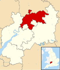
Map of Gloucestershire, UK with Tewkesbury highlighted. Equirectangular map projection on WGS 84 datum, with N/S stretched 160% |
| 日付 | |
| 原典 |
|
| 作者 | Nilfanion, created using Ordnance Survey data |
| 許可 (ファイルの再利用) |
このファイルはクリエイティブ・コモンズ 表示-継承 3.0 非移植ライセンスのもとに利用を許諾されています。 帰属: Contains Ordnance Survey data © Crown copyright and database right
|
ファイルの履歴
過去の版のファイルを表示するには、その版の日時をクリックしてください。
| 日付と時刻 | サムネイル | 寸法 | 利用者 | コメント | |
|---|---|---|---|---|---|
| 現在の版 | 2011年2月27日 (日) 12:30 | | 1,089 × 1,266 (1.09メガバイト) | Nilfanion | {{Information |Description=Map of Gloucestershire, UK with Tewkesbury highlighted. Equirectangular map projection on WGS 84 datum, with N/S stretched 160% |Source=Ordnance Survey [htt |
ファイルの使用状況
このファイルを使用しているページはありません。
グローバルなファイル使用状況
以下に挙げる他のウィキがこの画像を使っています:
- bg.wikipedia.org での使用状況
- cy.wikipedia.org での使用状況
- de.wikipedia.org での使用状況
- en.wikipedia.org での使用状況
- es.wikipedia.org での使用状況
- fr.wikipedia.org での使用状況
- Brockworth
- Tewkesbury (district)
- Tewkesbury
- Winchcombe
- Snowshill
- Deerhurst
- Liste des paroisses civiles du Gloucestershire
- Toddington (Gloucestershire)
- Modèle:Palette Tewkesbury
- Alderton (Gloucestershire)
- Ashchurch
- Ashleworth
- Badgeworth
- Bishop's Cleeve
- Boddington (Gloucestershire)
- Buckland (Gloucestershire)
- Chaceley
- Churchdown
- Down Hatherley
- Dumbleton
- Elmstone Hardwicke
- Forthampton
- Gotherington
- Great Witcombe
- Gretton (Gloucestershire)
- Hasfield
- Hawling
- Highnam
- Woodmancote (Tewkesbury)
- Wheatpieces
- Uckington (Gloucestershire)
- Twyning
- Twigworth
- Tirley
- Teddington (Gloucestershire)
- Sudeley
- Stoke Orchard
- Staverton (Gloucestershire)
- Stanway (Gloucestershire)
- Stanton (Gloucestershire)
- Southam (Gloucestershire)
- Shurdington
- Sandhurst (Gloucestershire)
- Prescott (Gloucestershire)
このファイルのグローバル使用状況を表示する。