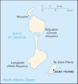
ファイル:Saint Pierre and Miquelon map.gif
Saint_Pierre_and_Miquelon_map.gif (330 × 354 ピクセル、ファイルサイズ: 7キロバイト、MIME タイプ: image/gif)
ファイルの履歴
過去の版のファイルを表示するには、その版の日時をクリックしてください。
| 日付と時刻 | サムネイル | 寸法 | 利用者 | コメント | |
|---|---|---|---|---|---|
| 現在の版 | 2005年6月26日 (日) 08:08 |  | 330 × 354 (7キロバイト) | Taichi | This is a map of Saint-Pierre and Miquelon from the CIA World Factbook (retrieved from http://www.cia.gov/cia/publications/factbook/geos/sb.html). According to the copyright notice on the website, all information of the World Factbook is in the public do |
ファイルの使用状況
以下のページがこのファイルを使用しています:
グローバルなファイル使用状況
以下に挙げる他のウィキがこの画像を使っています:
- be-tarask.wikipedia.org での使用状況
- be.wikipedia.org での使用状況
- bn.wikipedia.org での使用状況
- ca.wikipedia.org での使用状況
- cs.wikipedia.org での使用状況
- dsb.wikipedia.org での使用状況
- el.wikipedia.org での使用状況
- en.wikipedia.org での使用状況
- eo.wikipedia.org での使用状況
- es.wikipedia.org での使用状況
- eu.wikipedia.org での使用状況
- fa.wikipedia.org での使用状況
- fi.wikipedia.org での使用状況
- fo.wikipedia.org での使用状況
- fr.wikipedia.org での使用状況
- hu.wikipedia.org での使用状況
- id.wikipedia.org での使用状況
- incubator.wikimedia.org での使用状況
- io.wikipedia.org での使用状況
- it.wikipedia.org での使用状況
- kk.wikipedia.org での使用状況
- ko.wikipedia.org での使用状況
- ko.wiktionary.org での使用状況
- lt.wikipedia.org での使用状況
- mk.wikipedia.org での使用状況
- nl.wikipedia.org での使用状況
- nn.wikipedia.org での使用状況
- no.wikipedia.org での使用状況
- os.wikipedia.org での使用状況
- pl.wikipedia.org での使用状況
- pl.wiktionary.org での使用状況
このファイルのグローバル使用状況を表示する。


