
ファイル:Persian invasion.png
このプレビューのサイズ: 430 × 599 ピクセル。 その他の解像度: 172 × 240 ピクセル | 538 × 750 ピクセル。
元のファイル (538 × 750 ピクセル、ファイルサイズ: 41キロバイト、MIME タイプ: image/png)
ウィキメディア・コモンズのファイルページにある説明を、以下に表示します。
|
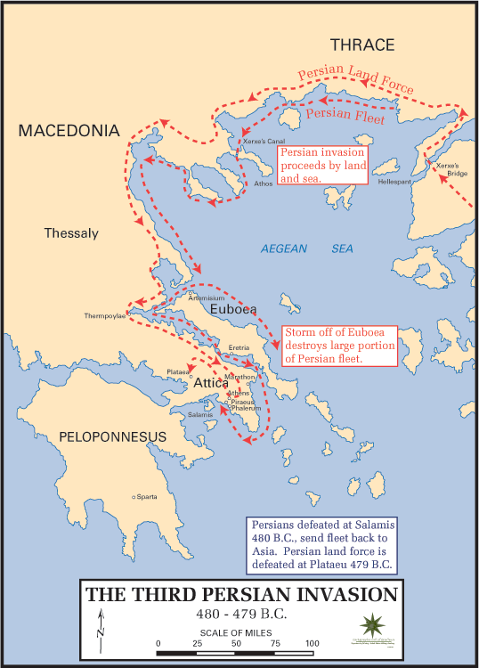
English: Map of the Persian invasion of Greece (480 BC-479 BC). Taken from
Català: Mapa de la invasió pèrsica de Grècia (480 aC - 479 aC). Obtingut de:
http://www.dean.usma.edu/history/atlases/ancient_warfare/persian_invasion_3.html

|
この文書は、フリーソフトウェア財団発行のGNUフリー文書利用許諾書 (GNU Free Documentation License) 1.2またはそれ以降のバージョンの規約に基づき、複製や再配布、改変が許可されます。不可変更部分、表紙、背表紙はありません。このライセンスの複製は、GNUフリー文書利用許諾書という章に含まれています。 |
This is the first of two images, the second being Image:Battle thermopylae.png.
ファイルの履歴
過去の版のファイルを表示するには、その版の日時をクリックしてください。
| 日付と時刻 | サムネイル | 寸法 | 利用者 | コメント | |
|---|---|---|---|---|---|
| 現在の版 | 2007年12月9日 (日) 05:16 | | 538 × 750 (41キロバイト) | AnonMoos | Reverted to version as of 16:13, 24 February 2006 - rv overwriting of completely different image |
| 2007年12月9日 (日) 02:25 |  | 653 × 520 (369キロバイト) | Megistias | == Summary == {{Information |Description=Map of "Map of the Persian invasion of Greece (480 BC-479 BC)" |Source=Own work.Data from dtv-Atlas Weltgeschichte. Von den Anfängen bis zur Gegenwart, p. 56. & from previous map whose link seems to be dead. |Date | |
| 2006年2月24日 (金) 16:13 |  | 538 × 750 (41キロバイト) | Brian Boru | Map of the Persian invasion of Greece (480 BC-479 BC). Taken from http://www.dean.usma.edu/history/atlases/ancient_warfare/persian_invasion_3.html {{CopyrightedFreeUseProvidedThat|the source is quoted: «''Maps Courtesy of the Department of History, Unit |
ファイルの使用状況
以下のページがこのファイルを使用しています:
グローバルなファイル使用状況
以下に挙げる他のウィキがこの画像を使っています:
- be.wikipedia.org での使用状況
- bg.wikipedia.org での使用状況
- ca.wikipedia.org での使用状況
- cy.wikipedia.org での使用状況
- en.wikipedia.org での使用状況
- es.wikipedia.org での使用状況
- fi.wikipedia.org での使用状況
- fr.wikipedia.org での使用状況
- gl.wikipedia.org での使用状況
- it.wikipedia.org での使用状況
- no.wikipedia.org での使用状況
- pl.wikibooks.org での使用状況
- pt.wikipedia.org での使用状況
- ro.wikipedia.org での使用状況
- sh.wikipedia.org での使用状況
- simple.wikipedia.org での使用状況
- sv.wikipedia.org での使用状況
- zh.wikipedia.org での使用状況