
ファイル:Nansen Fram Map.png
高解像度版はありません。
Nansen_Fram_Map.png (800 × 479 ピクセル、ファイルサイズ: 195キロバイト、MIME タイプ: image/png)
ウィキメディア・コモンズのファイルページにある説明を、以下に表示します。
|
概要
| 解説 |
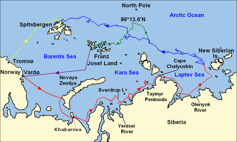
Map of the Arctic Ocean showing the routes taken during the 1893–96 Nansen's Fram expedition: Fram's route eastward from Vardø to the Siberian coast, turning north at the New Siberian Islands to enter the pack ice. July – September 1893 Fram's drift in the ice from the New Siberian Islands, north and west to Spitsbergen, September 1893 – August 1896 Nansen and Johansen's march to Farthest North, 86°20'N, and their subsequent retreat to Cape Flora in Franz Josef Land. February 1895 – June 1896 Nansen and Johansen's return to Vardø from Cape Flora, August 1896 Fram's voyage from Spitsbergen to Tromsø, August 1896 |
| 日付 | |
| 原典 | Base map of European and Asian mainland is from File:Map of Russian Subjects old.png by User:fremantleboy, map of Spitsbergen (Svalbard) is based on File:Bjornoya map.png by User:NormanEinstein. Voyage traces based on this map from The Northern Lights Route. First published in Nansen, Fridtjof: Farthest North, Constable & Co, London 1897 |
| 作者 | User:fremantleboy, User:NormanEinstein, Ruhrfisch |
| 許可 (ファイルの再利用) |
GFDL, CC-BY-SA |
| その他のバージョン |
|


|
このファイルのベクター画像 (SVG) が利用できます。 使う目的に対し、元画像よりもSVGがより優れている場合、SVG画像を使用して下さい。
File:Nansen Fram Map.png → File:Nansen Fram Map.svg
|
 |
ライセンス
この作品の著作権者である私は、この作品を以下のライセンスで提供します。

|
この文書は、フリーソフトウェア財団発行のGNUフリー文書利用許諾書 (GNU Free Documentation License) 1.2またはそれ以降のバージョンの規約に基づき、複製や再配布、改変が許可されます。不可変更部分、表紙、背表紙はありません。このライセンスの複製は、GNUフリー文書利用許諾書という章に含まれています。 |
This file is licensed under the Creative Commons Attribution-Share Alike 4.0 International, 3.0 Unported, 2.5 Generic, 2.0 Generic and 1.0 Generic license.
- あなたは以下の条件に従う場合に限り、自由に
- 共有 – 本作品を複製、頒布、展示、実演できます。
- 再構成 – 二次的著作物を作成できます。
- あなたの従うべき条件は以下の通りです。
- 表示 – あなたは適切なクレジットを表示し、ライセンスへのリンクを提供し、変更があったらその旨を示さなければなりません。これらは合理的であればどのような方法で行っても構いませんが、許諾者があなたやあなたの利用行為を支持していると示唆するような方法は除きます。
- 継承 – もしあなたがこの作品をリミックスしたり、改変したり、加工した場合には、あなたはあなたの貢献部分を元の作品とこれと同一または互換性があるライセンスの下に頒布しなければなりません。
あなたは上記のライセンスから、どれか一つ以上を選択できます。
ファイルの履歴
過去の版のファイルを表示するには、その版の日時をクリックしてください。
| 日付と時刻 | サムネイル | 寸法 | 利用者 | コメント | |
|---|---|---|---|---|---|
| 現在の版 | 2011年5月8日 (日) 12:16 | | 800 × 479 (195キロバイト) | Chris55 | Added [http://website.lineone.net/~polar.publishing/khabarova.htm Khabarova] where they picked up the dogs. |
| 2009年10月21日 (水) 15:50 |  | 1,003 × 601 (78キロバイト) | Ruhrfisch | Make arrowheads less triangular (indentations at rear) | |
| 2009年10月21日 (水) 15:23 |  | 1,003 × 601 (78キロバイト) | Ruhrfisch | Add arrowheads per FAC | |
| 2009年10月20日 (火) 18:50 |  | 1,003 × 601 (78キロバイト) | Ruhrfisch | Make magenta line purple | |
| 2009年10月11日 (日) 13:36 |  | 1,003 × 601 (78キロバイト) | Ruhrfisch | Yellow line for orange, some labels smaller, Farthest North replaced with actual figure, all other info the same | |
| 2009年10月11日 (日) 03:08 |  | 1,003 × 601 (80キロバイト) | Ruhrfisch | Darker green for that line, all other information is the same | |
| 2009年10月11日 (日) 02:46 |  | 1,003 × 601 (80キロバイト) | Ruhrfisch | Added last two lines for ice voyages, added last labels, all other information the same. | |
| 2009年10月9日 (金) 19:30 |  | 1,003 × 601 (73キロバイト) | Ruhrfisch | Add labels, two more voyage lines, all other information is the same | |
| 2009年10月9日 (金) 16:12 |  | 1,003 × 601 (57キロバイト) | Ruhrfisch | == Summary == {{Information |Description = Map of the Arctic Ocean showing the path of Nansen's Fram expedition 1893 to 1896 |Source = Base map of European mainland is from [[:File:Map of Russian Subjects old.png] |
ファイルの使用状況
以下のページがこのファイルを使用しています:
グローバルなファイル使用状況
以下に挙げる他のウィキがこの画像を使っています:
- bg.wikipedia.org での使用状況
- en.wikipedia.org での使用状況
- es.wikipedia.org での使用状況
- fr.wikipedia.org での使用状況
- hr.wikipedia.org での使用状況
- id.wikipedia.org での使用状況
- pt.wikipedia.org での使用状況
- sl.wikipedia.org での使用状況