
ファイル:Map of Florida by John de Solís (1764).jpg

このプレビューのサイズ: 460 × 599 ピクセル。 その他の解像度: 184 × 240 ピクセル | 368 × 480 ピクセル | 589 × 768 ピクセル | 786 × 1,024 ピクセル | 2,075 × 2,704 ピクセル。
元のファイル (2,075 × 2,704 ピクセル、ファイルサイズ: 634キロバイト、MIME タイプ: image/jpeg)
ウィキメディア・コモンズのファイルページにある説明を、以下に表示します。
|
.jpg?uselang=ja)
.jpg?uselang=ja)
.jpg?uselang=ja&action=history)
.jpg)
概要
| 解説 |
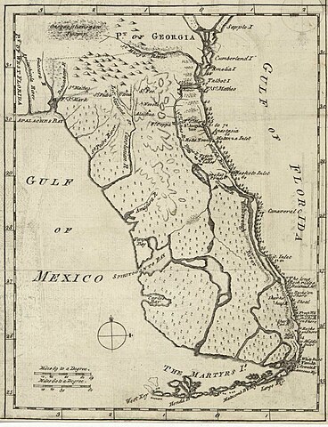
English: Map of Florida of ca. 1764]].
|
| 日付 | 1764年頃 |
| 原典 | US Library of Congress |
| 作者 | "Don John de Solís, surveyor, who resided there near twenty years" |
ライセンス
|
この著作物は、著作権の保護期間が著作者の死後100年以下である国・地域においてパブリックドメインの状態にあります。 | |
| このファイルは著作権法の既知の制約(隣接権や関連する権利を含む)から自由であると特定されています。 | |
ファイルの履歴
過去の版のファイルを表示するには、その版の日時をクリックしてください。
| 日付と時刻 | サムネイル | 寸法 | 利用者 | コメント | |
|---|---|---|---|---|---|
| 現在の版 | 2018年5月27日 (日) 23:06 | | 2,075 × 2,704 (634キロバイト) | Hispalois | Higher-resolution image. Please note that this map has no relationship whatsoever with 16th-century explorer Juan Díaz de Solís. |
| 2006年6月15日 (木) 17:16 |  | 399 × 500 (49キロバイト) | Eamezaga | Map published in the US depicting a very accurate shape of Florida (1764), based on an ancient draft drawn by the Spanish-Portuguese explorer and discoverer Juan Díaz de Solís (US Library of Congress, released to public domain) |
ファイルの使用状況
このファイルを使用しているページはありません。
グローバルなファイル使用状況
以下に挙げる他のウィキがこの画像を使っています:
- en.wikipedia.org での使用状況
- it.wikipedia.org での使用状況
.jpg)