
ファイル:MapaMacau1912.jpg
このプレビューのサイズ: 416 × 599 ピクセル。 その他の解像度: 167 × 240 ピクセル | 631 × 908 ピクセル。
元のファイル (631 × 908 ピクセル、ファイルサイズ: 81キロバイト、MIME タイプ: image/jpeg)
ウィキメディア・コモンズのファイルページにある説明を、以下に表示します。
|
概要
| 解説 |
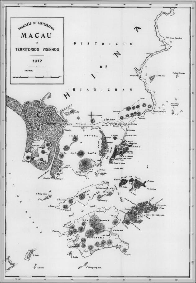
English: This is a map of Macau and is surrounded territories in 1912. In that time, the Portuguese Colony of Macau is formed by the Peninsula de Macau, Taipa and Coloane islands. Macau also have a great influence on the islands of Lapa, D. João and Montanha, located on the west of the Portuguese Colony of Macau. See here for original color version. |
| 日付 | |
| 原典 | |
| 作者 |
ライセンス
この著作物はマカオ政府の著作物であり、マカオにおいてパブリックドメインの状態にあり、その他の管轄区域においても同様の状態にある可能性があります。中国語、ポルトガル語(マカオの公用語)、及び英語(マカオの非公用語)でパブリックドメインとなっている資料の種類については、こちらをご覧ください。
|
 | |
| 注釈 | この画像には注釈がついています: コモンズで注釈を見る |
ファイルの履歴
過去の版のファイルを表示するには、その版の日時をクリックしてください。
| 日付と時刻 | サムネイル | 寸法 | 利用者 | コメント | |
|---|---|---|---|---|---|
| 現在の版 | 2007年2月14日 (水) 09:34 | | 631 × 908 (81キロバイト) | AdriAg | This is a map of Macau and is surrounded territories in 1912. In that time, the Portuguese Colony of Macau is formed by the [http://pt.wikipedia.org/wiki/Pen%C3%ADnsula_de_Macau Peninsula de Macau], [http://pt.wikipedia.org/wiki/Taipa Taipa] and [http://p |
ファイルの使用状況
以下のページがこのファイルを使用しています:
グローバルなファイル使用状況
以下に挙げる他のウィキがこの画像を使っています:
- en.wikipedia.org での使用状況
- es.wikipedia.org での使用状況
- fa.wikipedia.org での使用状況
- fr.wikipedia.org での使用状況
- it.wikipedia.org での使用状況
- mwl.wikipedia.org での使用状況
- nl.wikipedia.org での使用状況
- no.wikipedia.org での使用状況
- pt.wikipedia.org での使用状況
- ru.wikipedia.org での使用状況
- ur.wikipedia.org での使用状況
- zh.wikipedia.org での使用状況