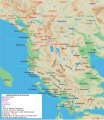
ファイル:Map of ancient Epirus and environs (English).svg

ページのコンテンツが他言語でサポートされていません。

元のファイル(SVG ファイル、1,303 × 1,500 ピクセル、ファイルサイズ: 495キロバイト)

このファイルを翻訳

このSVGファイルには翻訳可能な埋め込みテキストが含まれています。SVG翻訳ツールや他のSVGエディタを使用して自分の言語に翻訳可能です。詳しくはSVGファイルの翻訳についてを参照してください。

概要

解説
English: Map of ancient Epirus & Environs, Thracian, Illyrian, Paeonian, & Greek contact zones with illustration and extent of Hellenization up to the creation of Epirus Nova or Illyria Graeca
日付
原典 投稿者自身による著作物
作者 MaryroseB54
その他のバージョン

[編集]

  • The classical age of Greece (1999),
  • ed. Atlas of the Greek and Roman world in antiquity (1981).
  • Hammond, N. G. L. A History of Greece to 322 B.C., 1986, ISBN-10: 0198730950
  • Wilkes, J. J. The Illyrians, 1992,ISBN 0631198075, (i.e. pages 174, 208, 210, 273)
  • In the Shadow of Olympus: The Emergence of Macedon,ISBN 0691008809,1992
  • Thracian Tribal areas (from Fol, Thrace and the Thracians, p 133),The Thracians 700 BC–AD 46 (Men-at-Arms 360) by Christopher Webber After Hoddinot, Col & Cah
  • Hendry, p. 299. The geography is entirely correct for Servius' time, since Diocletian's rearrangement of provincial boundaries included the creation of the province of Epirus Nova out of southern Illyricum with Dyrrachium (=Epidamnus) as its capital.
  • The Loeb Editor's Notes, 28 Nova Epirus or Illyris Graeca (Epirus, Nova Illyria Graeca) "Nova Epirus or Illyris Graeca extended from the Drilo (Mod. Drina) River on the north to the Ceraunian Mts. on the south, thus comprising a large part of modern Albania. Immediately to the south of it to the Ambracian Gulf (Mod. Gulf of Arta) lay what is here called Old Epirus, approximately identical with the Epirus of modern Greece."
  • Soustal, Peter; Koder, Johannes (1981). Tabula Imperii Byzantini, Band 3: Nikopolis und Kephallenia (in German). Vienna: Verlag der Osterreichischen Akademie der Wissenschaften. ISBN 3-7001-0399-9., page 47
  • A new classical dictionary of Greek and Roman biography, mythology, and geography: partly based upon the Dictionary of Greek and Roman biography and mythology by Sir William Smith,1851,page 392 "B. Illyris Graeca, which was called in later times Epirus Nova, extended from the river Drilo to the SE., up to the Ceraunian mountains, which separated it from Epirus Proper"
  • American journal of philology, Τόμοι 98-99,by JSTOR (Organization), Project Muse,1977,page 263, the partly Hellenic and partly Hellenized Epirus Nova
  • Epirus Vetus: The Archaeology of a Late Antique Province (Duckworth Archaeology) by William Bowden,2003,ISBN-10: 0715631160,2003,page 233,of Lissos in Epirus Nova
  • Migrations and invasions in Greece and adjacent areas by Nicholas Geoffrey Lempriere Hammond,1976,ISBN -0815550472,page 54,The line of division between Illyricum and the Greek area Epirus nova
  • Athanassakis, A.N. (1977), "N.G.L. Hammond, Migrations and Invasions in Greece and Adjacent Areas (review)", American Journal of Philology 99: 263–6, JSTOR 293653
  • Hammond, N. G. L. A History of Greece to 322 B.C., 1986, ISBN-10: 0198730950
  • Triadafilopoulos, Triadafilos (November 2000). "Power politics and nationalist discourse in the struggle for 'Northern Epirus': 1919-1921". Journal of Southern Europe and the Balkans,
  • Encyclopedia Britannica,2002,ISBN -0852297874,The Roman province of Illyricum stretched from the Drilon River (the Drin, in modern Albania) in the south to Istria (modem Slovenia and Croatia)
  • History of the Byzantine Empire: Vol. 1, 324-1453 (Paperback) by Alexander A. Vasiliev
  • Epire, Illyrie, Macedoine: melanges offerts au professeur Pierre Cabanes by Daniele Berranger,Pierre Cabanes,Daniele Berranger-Auserve,page 130
  • In An Inventory of Archaic and Classical Poleis by Mogens Herman, ISBN 0-19-814099-1, 2004, i.e. "As a long-distance trading community, Aigina was not an active coloniser, but colonised Kydonia (no. 968) in 519, Adria (no. 75) c.C61, and Damastion in Illyria after 431 (Strabo 8.6.16)." & page 348
  • The Cambridge Ancient History: The Hellenistic monarchies and the rise of Rome, 1964. page 836 "of mixed barbarian and Greek population, such as Dimale (or Dimallum), of unknown"
  • The Illyrian Atintani, the Epirotic Atintanes and the Roman Protectorate N. G. L. Hammond, The Journal of Roman Studies Vol. 79 (1989), pp. 11-25 "There were Illyrian Amantini in Pannonia and Greek Amantes in North Epirus"
  • Blank map from Image:Map greek sanctuaries-fr.svg (The empty map used is not topographic, nor does it offer the capacity of gps precision, but its easy on the eyes and aesthetically pleasing in general)

ライセンス

この作品の著作権者である私は、この作品を以下のライセンスで提供します。
w:ja:クリエイティブ・コモンズ
表示 継承
このファイルはクリエイティブ・コモンズ 表示-継承 4.0 国際ライセンスのもとに利用を許諾されています。
あなたは以下の条件に従う場合に限り、自由に
  • 共有 – 本作品を複製、頒布、展示、実演できます。
  • 再構成 – 二次的著作物を作成できます。
あなたの従うべき条件は以下の通りです。
  • 表示 – あなたは適切なクレジットを表示し、ライセンスへのリンクを提供し、変更があったらその旨を示さなければなりません。これらは合理的であればどのような方法で行っても構いませんが、許諾者があなたやあなたの利用行為を支持していると示唆するような方法は除きます。
  • 継承 – もしあなたがこの作品をリミックスしたり、改変したり、加工した場合には、あなたはあなたの貢献部分を元の作品とこれと同一または互換性があるライセンスの下に頒布しなければなりません。
注釈
InfoField
この画像には注釈がついています: コモンズで注釈を見る

キャプション

このファイルの内容を1行で記述してください

このファイルに描写されている項目

題材

19 6 2016

ファイルの履歴

過去の版のファイルを表示するには、その版の日時をクリックしてください。

日付と時刻サムネイル寸法利用者コメント
現在の版2021年11月22日 (月) 04:382021年11月22日 (月) 04:38時点における版のサムネイル1,303 × 1,500 (495キロバイト)KhirurgMeant to upload this version
2021年11月22日 (月) 04:222021年11月22日 (月) 04:22時点における版のサムネイル1,303 × 1,500 (495キロバイト)KhirurgMade some corrections
2020年12月28日 (月) 01:362020年12月28日 (月) 01:36時点における版のサムネイル1,303 × 1,500 (493キロバイト)CastellFile uploaded using svgtranslate tool (https://svgtranslate.toolforge.org/). Added translation for ca.
2020年12月28日 (月) 01:262020年12月28日 (月) 01:26時点における版のサムネイル1,303 × 1,500 (492キロバイト)CastellFile uploaded using svgtranslate tool (https://svgtranslate.toolforge.org/). Added translation for ca.
2016年6月24日 (金) 11:152016年6月24日 (金) 11:15時点における版のサムネイル1,303 × 1,500 (383キロバイト)MaryroseB54Parthos
2016年6月22日 (水) 23:582016年6月22日 (水) 23:58時点における版のサムネイル1,303 × 1,500 (382キロバイト)MaryroseB54as per source
2016年6月22日 (水) 22:522016年6月22日 (水) 22:52時点における版のサムネイル1,303 × 1,500 (382キロバイト)MaryroseB54Position
2016年6月22日 (水) 21:072016年6月22日 (水) 21:07時点における版のサムネイル1,303 × 1,500 (382キロバイト)MaryroseB54Position fix
2016年6月20日 (月) 10:062016年6月20日 (月) 10:06時点における版のサムネイル1,303 × 1,500 (382キロバイト)MaryroseB54User created page with UploadWizard

以下の​ 5 ページがこのファイルを使用しています:

グローバルなファイル使用状況

以下に挙げる他のウィキがこの画像を使っています:

このファイルのグローバル使用状況を表示する。

メタデータ